Provencal Topo Map Louisiana
To zoom in, hover over the map of Provencal
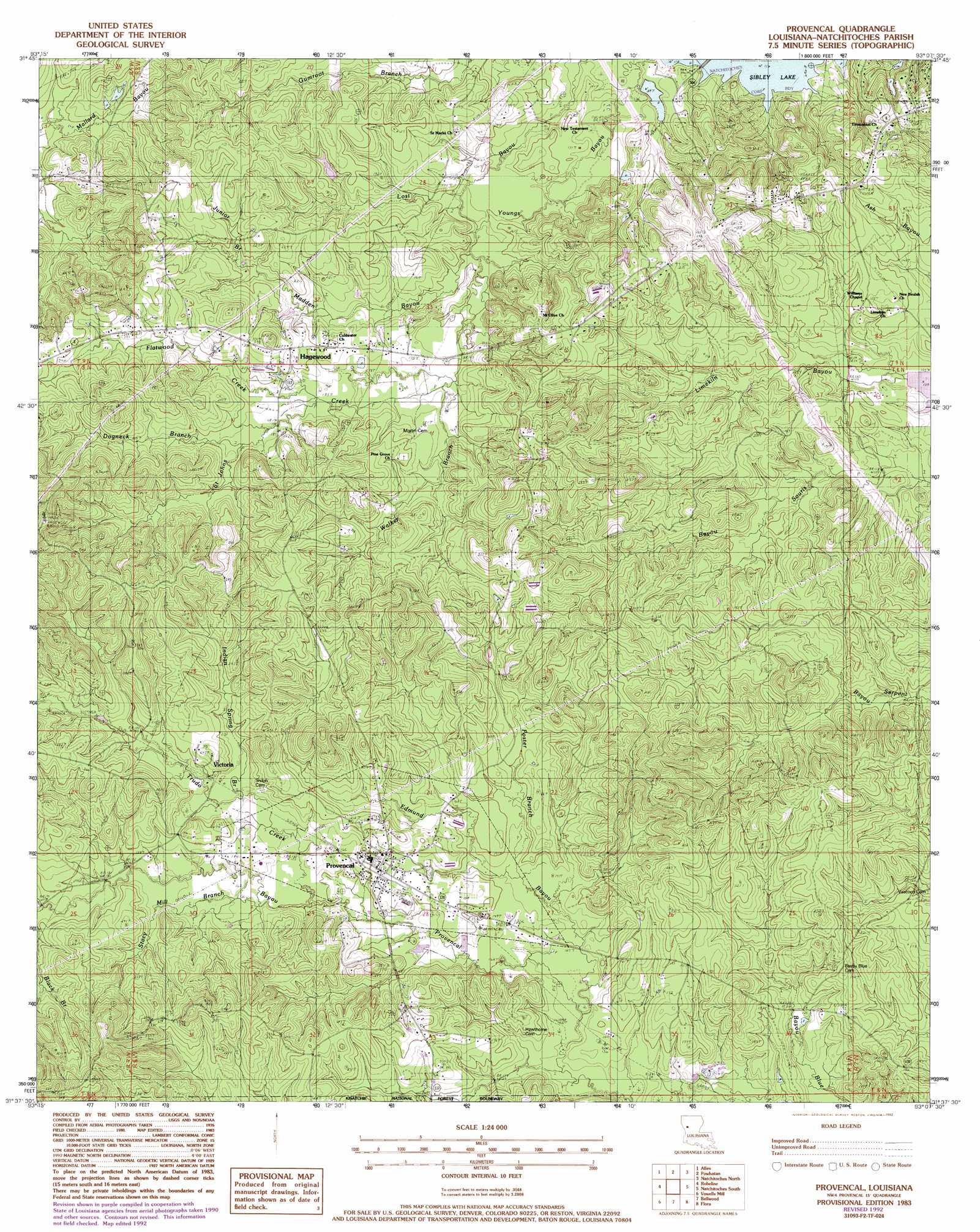
USGS Topo Quad 31093f2 - 1:24,000 scale
| Topo Map Name: | Provencal |
| USGS Topo Quad ID: | 31093f2 |
| Print Size: | ca. 21 1/4" wide x 27" high |
| Southeast Coordinates: | 31.625° N latitude / 93.125° W longitude |
| Map Center Coordinates: | 31.6875° N latitude / 93.1875° W longitude |
| U.S. State: | LA |
| Filename: | o31093f2.jpg |
| Download Map JPG Image: | Provencal topo map 1:24,000 scale |
| Map Type: | Topographic |
| Topo Series: | 7.5´ |
| Map Scale: | 1:24,000 |
| Source of Map Images: | United States Geological Survey (USGS) |
| Alternate Map Versions: |
Provencal LA 1983, updated 1984 Download PDF Buy paper map Provencal LA 1983, updated 1992 Download PDF Buy paper map Provencal LA 2012 Download PDF Buy paper map Provencal LA 2015 Download PDF Buy paper map |
| FStopo: | US Forest Service topo Provencal is available: Download FStopo PDF Download FStopo TIF |
1:24,000 Topo Quads surrounding Provencal
Evelyn |
Hanna |
Messick |
Campti |
Coup Point |
Hollis Creek |
Allen |
Powhatan |
Natchitoches North |
Saint Maurice |
Marthaville |
Robeline |
Provencal |
Flora |
Montgomery |
Many |
Vowells Mill |
Bellwood |
Natchitoches South |
Cloutierville |
Florien |
Peason |
Kisatchie |
Bayou Livrogne |
Gorum |
> Back to 31093e1 at 1:100,000 scale
> Back to 31092a1 at 1:250,000 scale
> Back to U.S. Topo Maps home
Provencal topo map: Gazetteer
Provencal: Populated Places
Beechwood Estates elevation 52m 170′Breedlove Hills elevation 51m 167′
Hagewood elevation 67m 219′
Knightville (historical) elevation 65m 213′
Provencal elevation 52m 170′
Shamard Heights elevation 45m 147′
Victoria elevation 57m 187′
Provencal: Streams
Black Branch elevation 56m 183′Coal Kiln Creek elevation 56m 183′
Dogneck Branch elevation 56m 183′
Edmund Bayou elevation 39m 127′
Flatwood Creek elevation 54m 177′
Foster Branch elevation 41m 134′
Indian Spring Branch elevation 52m 170′
Junior Branch elevation 57m 187′
Madden Bayou elevation 46m 150′
Saint Johns Creek elevation 49m 160′
Stacy Mill Branch elevation 48m 157′
Trudo Creek elevation 47m 154′
Walker Branch elevation 49m 160′
Provencal digital topo map on disk
Buy this Provencal topo map showing relief, roads, GPS coordinates and other geographical features, as a high-resolution digital map file on DVD: