Powhatan Topo Map Louisiana
To zoom in, hover over the map of Powhatan
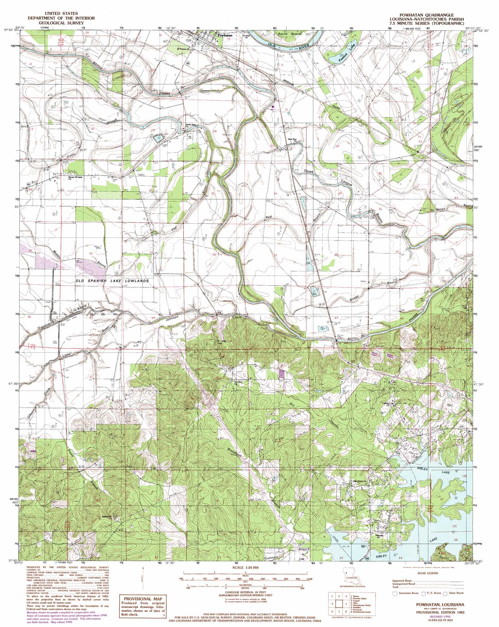
USGS Topo Quad 31093g2 - 1:24,000 scale
| Topo Map Name: | Powhatan |
| USGS Topo Quad ID: | 31093g2 |
| Print Size: | ca. 21 1/4" wide x 27" high |
| Southeast Coordinates: | 31.75° N latitude / 93.125° W longitude |
| Map Center Coordinates: | 31.8125° N latitude / 93.1875° W longitude |
| U.S. State: | LA |
| Filename: | o31093g2.jpg |
| Download Map JPG Image: | Powhatan topo map 1:24,000 scale |
| Map Type: | Topographic |
| Topo Series: | 7.5´ |
| Map Scale: | 1:24,000 |
| Source of Map Images: | United States Geological Survey (USGS) |
| Alternate Map Versions: |
Powhatan LA 1983, updated 1984 Download PDF Buy paper map Powhatan LA 1983, updated 1992 Download PDF Buy paper map Powhatan LA 1983, updated 1992 Download PDF Buy paper map Powhatan LA 2012 Download PDF Buy paper map Powhatan LA 2015 Download PDF Buy paper map |
1:24,000 Topo Quads surrounding Powhatan
Harmon |
Coushatta |
Martin |
Chestnut |
Goldonna |
Evelyn |
Hanna |
Messick |
Campti |
Coup Point |
Hollis Creek |
Allen |
Powhatan |
Natchitoches North |
Saint Maurice |
Marthaville |
Robeline |
Provencal |
Flora |
Montgomery |
Many |
Vowells Mill |
Bellwood |
Natchitoches South |
Cloutierville |
> Back to 31093e1 at 1:100,000 scale
> Back to 31092a1 at 1:250,000 scale
> Back to U.S. Topo Maps home
Powhatan topo map: Gazetteer
Powhatan: Bridges
Berry Bridge (historical) elevation 29m 95′Chute Bridge elevation 35m 114′
Powhatan: Flats
Old Spanish Lake Lowlands elevation 33m 108′Powhatan: Guts
Boggy Bayou elevation 36m 118′Coon Slough elevation 38m 124′
Flat River elevation 31m 101′
Middle Bayou elevation 35m 114′
Oldriver Red River elevation 32m 104′
Three League Bayou elevation 36m 118′
Powhatan: Lakes
Passoit Lake elevation 36m 118′Powhatan: Populated Places
Calvert Acres elevation 45m 147′Fairview Acres elevation 63m 206′
Forest elevation 41m 134′
Greenwood Park elevation 41m 134′
Highland Acres elevation 40m 131′
Oak Grove elevation 37m 121′
Oakhill elevation 45m 147′
Oakleaf Estates elevation 40m 131′
Powhatan elevation 37m 121′
Stephens elevation 45m 147′
Westlake elevation 42m 137′
Powhatan: Streams
Bayou Pierre elevation 32m 104′Breedlove Branch elevation 35m 114′
Gibson Ditch elevation 32m 104′
Gumroot Branch elevation 35m 114′
Johnson Chute elevation 33m 108′
Little River elevation 29m 95′
Lost Bayou elevation 36m 118′
Posey Branch elevation 32m 104′
Red Bayou elevation 29m 95′
Rio Hondo elevation 35m 114′
Powhatan digital topo map on disk
Buy this Powhatan topo map showing relief, roads, GPS coordinates and other geographical features, as a high-resolution digital map file on DVD: