Huxley Topo Map Texas
To zoom in, hover over the map of Huxley
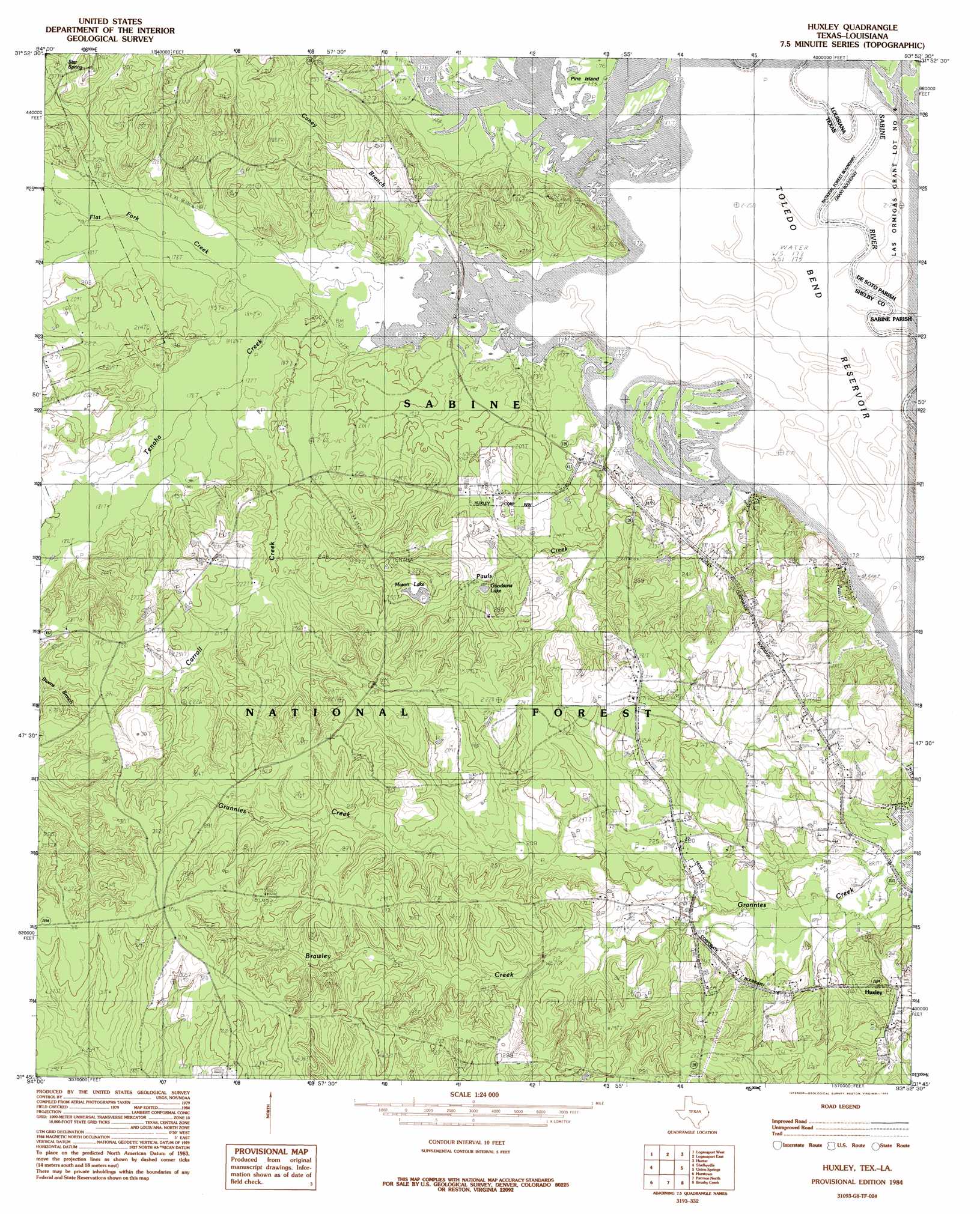
USGS Topo Quad 31093g8 - 1:24,000 scale
| Topo Map Name: | Huxley |
| USGS Topo Quad ID: | 31093g8 |
| Print Size: | ca. 21 1/4" wide x 27" high |
| Southeast Coordinates: | 31.75° N latitude / 93.875° W longitude |
| Map Center Coordinates: | 31.8125° N latitude / 93.9375° W longitude |
| U.S. States: | TX, LA |
| Filename: | o31093g8.jpg |
| Download Map JPG Image: | Huxley topo map 1:24,000 scale |
| Map Type: | Topographic |
| Topo Series: | 7.5´ |
| Map Scale: | 1:24,000 |
| Source of Map Images: | United States Geological Survey (USGS) |
| Alternate Map Versions: |
Huxley TX 1984, updated 1984 Download PDF Buy paper map Huxley TX 2003, updated 2004 Download PDF Buy paper map Huxley TX 2010 Download PDF Buy paper map Huxley TX 2012 Download PDF Buy paper map Huxley TX 2016 Download PDF Buy paper map |
| FStopo: | US Forest Service topo Huxley is available: Download FStopo PDF Download FStopo TIF |
1:24,000 Topo Quads surrounding Huxley
Old Center |
Galloway |
Longstreet |
Grand Cane |
Mansfield |
Tenaha East |
Logansport West |
Logansport East |
Hunter |
Trenton |
Center |
Shelbyville |
Huxley |
Union Springs |
Converse |
Neuville |
Hurstown |
Patroon North |
Brushy Creek |
Zwolle |
San Augustine West |
San Augustine East |
Patroon South |
East Hamilton |
Beech Bayou |
> Back to 31093e1 at 1:100,000 scale
> Back to 31092a1 at 1:250,000 scale
> Back to U.S. Topo Maps home
Huxley topo map: Gazetteer
Huxley: Bends
Wildcat Bend elevation 52m 170′Wildcat Bend elevation 52m 170′
Huxley: Lakes
Goodsons Lake elevation 65m 213′Mason Lake elevation 75m 246′
Old River Lake elevation 52m 170′
Tuckers Lake elevation 52m 170′
Huxley: Populated Places
Huxley elevation 85m 278′Huxley: Springs
National Forest Spring elevation 93m 305′Huxley: Streams
Brawley Creek elevation 58m 190′Caney Branch elevation 52m 170′
Carroll Creek elevation 54m 177′
Flat Fork Creek elevation 53m 173′
Pauls Creek elevation 52m 170′
Tenaha Bayou elevation 52m 170′
Tenaha Creek elevation 57m 187′
Turkey Creek elevation 52m 170′
Huxley: Swamps
Horseshoe Lake elevation 52m 170′Huxley digital topo map on disk
Buy this Huxley topo map showing relief, roads, GPS coordinates and other geographical features, as a high-resolution digital map file on DVD: