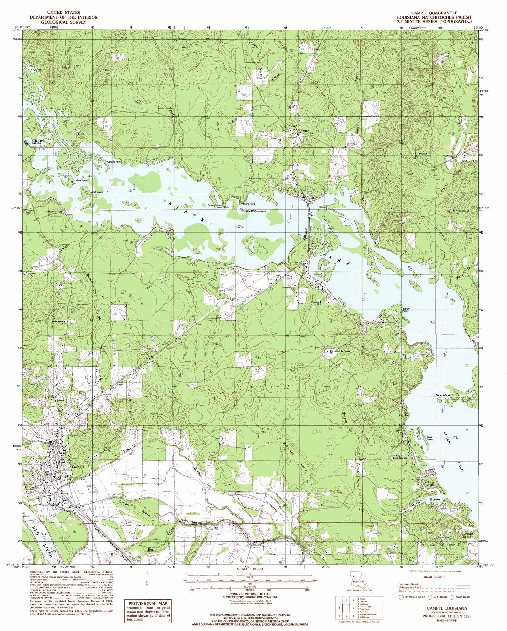
Campti Topo Map Louisiana
To zoom in, hover over the map of Campti
USGS Topo Quad 31093h1 - 1:24,000 scale
| Topo Map Name: | Campti |
| USGS Topo Quad ID: | 31093h1 |
| Print Size: | ca. 21 1/4" wide x 27" high |
| Southeast Coordinates: | 31.875° N latitude / 93° W longitude |
| Map Center Coordinates: | 31.9375° N latitude / 93.0625° W longitude |
| U.S. State: | LA |
| Filename: | o31093h1.jpg |
| Download Map JPG Image: | Campti topo map 1:24,000 scale |
| Map Type: | Topographic |
| Topo Series: | 7.5´ |
| Map Scale: | 1:24,000 |
| Source of Map Images: | United States Geological Survey (USGS) |
| Alternate Map Versions: |
Campti LA 1983, updated 1984 Download PDF Buy paper map Campti LA 1983, updated 1991 Download PDF Buy paper map Campti LA 1996, updated 1999 Download PDF Buy paper map Campti LA 2012 Download PDF Buy paper map Campti LA 2015 Download PDF Buy paper map |
1:24,000 Topo Quads surrounding Campti
Hall Summit |
Troy |
Ashland |
Saline |
Danville |
Coushatta |
Martin |
Chestnut |
Goldonna |
Iron Branch |
Hanna |
Messick |
Campti |
Coup Point |
Calvin |
Allen |
Powhatan |
Natchitoches North |
Saint Maurice |
Coochie Brake |
Robeline |
Provencal |
Flora |
Montgomery |
Verda |
> Back to 31093e1 at 1:100,000 scale
> Back to 31092a1 at 1:250,000 scale
> Back to U.S. Topo Maps home
Campti topo map: Gazetteer
Campti: Bays
Lemoine Slough elevation 30m 98′Morgan Bayou elevation 30m 98′
Wilmas Slough elevation 30m 98′
Campti: Capes
Agness Point elevation 30m 98′Campground Point elevation 30m 98′
Sandy Point elevation 30m 98′
Stove Point elevation 30m 98′
Campti: Crossings
Campti Ferry (historical) elevation 29m 95′Cloud Crossing (historical) elevation 31m 101′
Campti: Guts
Bayou Pratte elevation 35m 114′Campti: Islands
Bird Island elevation 31m 101′Button Willow Island elevation 30m 98′
Pecan Island elevation 31m 101′
Pine Island elevation 31m 101′
Sand Island elevation 30m 98′
Campti: Parks
Northwest Louisiana Fish and Game Preserve elevation 30m 98′Campti: Populated Places
Campti elevation 39m 127′Caspari (historical) elevation 37m 121′
Creston elevation 49m 160′
Campti: Post Offices
Creston Post Office elevation 44m 144′Campti: Reservoirs
Black Lake elevation 30m 98′Campti: Streams
Bayou Terry elevation 30m 98′Bryant Creek elevation 30m 98′
Caesar Creek elevation 42m 137′
Campti Bayou elevation 36m 118′
Cloud Creek elevation 31m 101′
Lewis Creek elevation 36m 118′
Lime Creek elevation 37m 121′
Morgan Creek elevation 30m 98′
Remy Creek elevation 31m 101′
Salt Creek elevation 30m 98′
The Coulee elevation 31m 101′
Weaver Slough elevation 31m 101′
Campti: Swamps
Campti Brake elevation 33m 108′Robeaux Brake elevation 34m 111′
Campti digital topo map on disk
Buy this Campti topo map showing relief, roads, GPS coordinates and other geographical features, as a high-resolution digital map file on DVD: