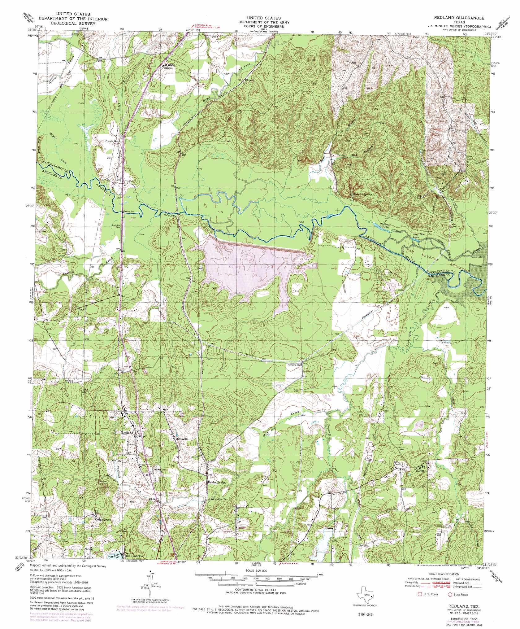
Redland Topo Map Texas
To zoom in, hover over the map of Redland
USGS Topo Quad 31094d6 - 1:24,000 scale
| Topo Map Name: | Redland |
| USGS Topo Quad ID: | 31094d6 |
| Print Size: | ca. 21 1/4" wide x 27" high |
| Southeast Coordinates: | 31.375° N latitude / 94.625° W longitude |
| Map Center Coordinates: | 31.4375° N latitude / 94.6875° W longitude |
| U.S. State: | TX |
| Filename: | o31094d6.jpg |
| Download Map JPG Image: | Redland topo map 1:24,000 scale |
| Map Type: | Topographic |
| Topo Series: | 7.5´ |
| Map Scale: | 1:24,000 |
| Source of Map Images: | United States Geological Survey (USGS) |
| Alternate Map Versions: |
Redland TX 1950 Download PDF Buy paper map Redland TX 1950 Download PDF Buy paper map Redland TX 1950, updated 1981 Download PDF Buy paper map Redland TX 1950, updated 1981 Download PDF Buy paper map Redland TX 2003, updated 2004 Download PDF Buy paper map Redland TX 2010 Download PDF Buy paper map Redland TX 2013 Download PDF Buy paper map Redland TX 2016 Download PDF Buy paper map |
| FStopo: | US Forest Service topo Redland is available: Download FStopo PDF Download FStopo TIF |
1:24,000 Topo Quads surrounding Redland
Douglas |
Lake Nacogdoches North |
Nacogdoches North |
Appleby |
Martinsville |
Durst Lakes |
Lake Nacogdoches South |
Nacogdoches South |
Woden |
Melrose |
Wells |
Clawson |
Redland |
Platt |
Etoile North |
Wells Sw |
Keltys |
Lufkin |
Huntington |
Etoile South |
Apple Springs |
Diboll |
Bald Hill |
Manning |
Zavalla |
> Back to 31094a1 at 1:100,000 scale
> Back to 31094a1 at 1:250,000 scale
> Back to U.S. Topo Maps home
Redland topo map: Gazetteer
Redland: Airports
Gravco Stolport elevation 82m 269′Just Plane Fun Airpark elevation 70m 229′
Redland: Bridges
Angelina River Bridge elevation 53m 173′Redland: Dams
Ellen Trout Memorial Lake Dam elevation 82m 269′Kurth Dam elevation 51m 167′
Redland: Islands
Lower Island elevation 60m 196′Redland: Lakes
Hog Pen Lake elevation 50m 164′Lake Kurth elevation 60m 196′
Shawnee Lake elevation 50m 164′
Redland: Populated Places
Cedar Grove elevation 103m 337′Climax elevation 58m 190′
Davisville elevation 98m 321′
Moffitt elevation 82m 269′
Redland elevation 104m 341′
River Crest Estates elevation 67m 219′
Redland: Reservoirs
City Lake elevation 81m 265′Ellen Trout Memorial Lake elevation 82m 269′
Kurth Lake elevation 61m 200′
Redland: Springs
Palisada Spring elevation 62m 203′Shawnee Mineral Springs elevation 95m 311′
Shawnee Spring elevation 57m 187′
Redland: Streams
Bayou La Nana elevation 53m 173′Bayou oa Nana elevation 53m 173′
Black Bayou elevation 54m 177′
Little Creek elevation 71m 232′
Little Red Branch elevation 50m 164′
Mill Creek elevation 58m 190′
Morral Bayou elevation 58m 190′
Paper Mill Creek elevation 50m 164′
Procella Creek elevation 53m 173′
Red Branch elevation 53m 173′
Tom Creek elevation 54m 177′
Venable Branch elevation 50m 164′
Willis Creek elevation 63m 206′
Redland digital topo map on disk
Buy this Redland topo map showing relief, roads, GPS coordinates and other geographical features, as a high-resolution digital map file on DVD: