Shelbyville Topo Map Texas
To zoom in, hover over the map of Shelbyville
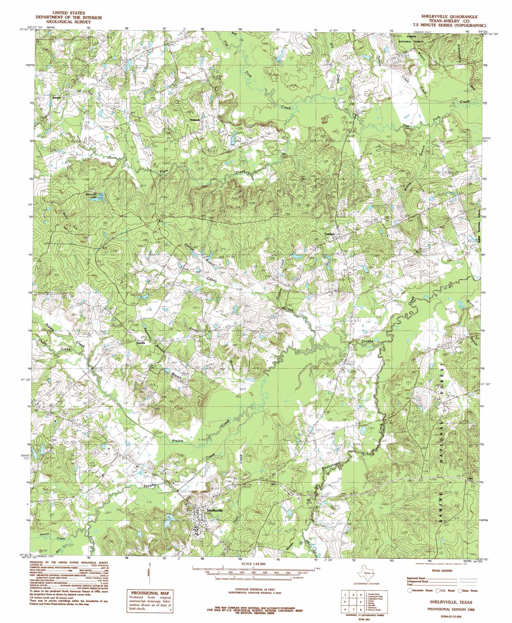
USGS Topo Quad 31094g1 - 1:24,000 scale
| Topo Map Name: | Shelbyville |
| USGS Topo Quad ID: | 31094g1 |
| Print Size: | ca. 21 1/4" wide x 27" high |
| Southeast Coordinates: | 31.75° N latitude / 94° W longitude |
| Map Center Coordinates: | 31.8125° N latitude / 94.0625° W longitude |
| U.S. State: | TX |
| Filename: | o31094g1.jpg |
| Download Map JPG Image: | Shelbyville topo map 1:24,000 scale |
| Map Type: | Topographic |
| Topo Series: | 7.5´ |
| Map Scale: | 1:24,000 |
| Source of Map Images: | United States Geological Survey (USGS) |
| Alternate Map Versions: |
Shelbyville TX 1984, updated 1985 Download PDF Buy paper map Shelbyville TX 2003, updated 2004 Download PDF Buy paper map Shelbyville TX 2010 Download PDF Buy paper map Shelbyville TX 2013 Download PDF Buy paper map Shelbyville TX 2016 Download PDF Buy paper map |
| FStopo: | US Forest Service topo Shelbyville is available: Download FStopo PDF Download FStopo TIF |
1:24,000 Topo Quads surrounding Shelbyville
Gary |
Old Center |
Galloway |
Longstreet |
Grand Cane |
Tenaha West |
Tenaha East |
Logansport West |
Logansport East |
Hunter |
Arcadia |
Center |
Shelbyville |
Huxley |
Union Springs |
Mount Herman |
Neuville |
Hurstown |
Patroon North |
Brushy Creek |
Chireno North |
San Augustine West |
San Augustine East |
Patroon South |
East Hamilton |
> Back to 31094e1 at 1:100,000 scale
> Back to 31094a1 at 1:250,000 scale
> Back to U.S. Topo Maps home
Shelbyville topo map: Gazetteer
Shelbyville: Dams
Bone Hill Lake Dam elevation 83m 272′Windham Lake Dam elevation 72m 236′
Shelbyville: Populated Places
Antioch elevation 78m 255′Campti elevation 88m 288′
James elevation 90m 295′
Sardis elevation 86m 282′
Shelbyville elevation 89m 291′
Shelbyville: Reservoirs
Bone Hill Lake elevation 82m 269′Windham Lake elevation 72m 236′
Shelbyville: Streams
Beauchamp Creek elevation 58m 190′Bell Creek elevation 72m 236′
Bivens Branch elevation 56m 183′
Blankenship Creek elevation 55m 180′
Caney Creek elevation 61m 200′
Carlyle Branch elevation 67m 219′
Clark Creek elevation 64m 209′
Cooney Creek elevation 65m 213′
Dry Creek elevation 57m 187′
Huana Creek elevation 69m 226′
Mill Creek elevation 68m 223′
Morrison Creek elevation 72m 236′
Plum Creek elevation 58m 190′
Porter Creek elevation 69m 226′
Prairie Creek elevation 65m 213′
Sardis Branch elevation 62m 203′
Seymour Watson Branch elevation 63m 206′
Talbert Creek elevation 55m 180′
Town Creek elevation 62m 203′
Watery Creek elevation 55m 180′
Willsie Branch elevation 55m 180′
Wolf Creek elevation 60m 196′
Shelbyville: Summits
Bone Hill elevation 105m 344′Shelbyville digital topo map on disk
Buy this Shelbyville topo map showing relief, roads, GPS coordinates and other geographical features, as a high-resolution digital map file on DVD: