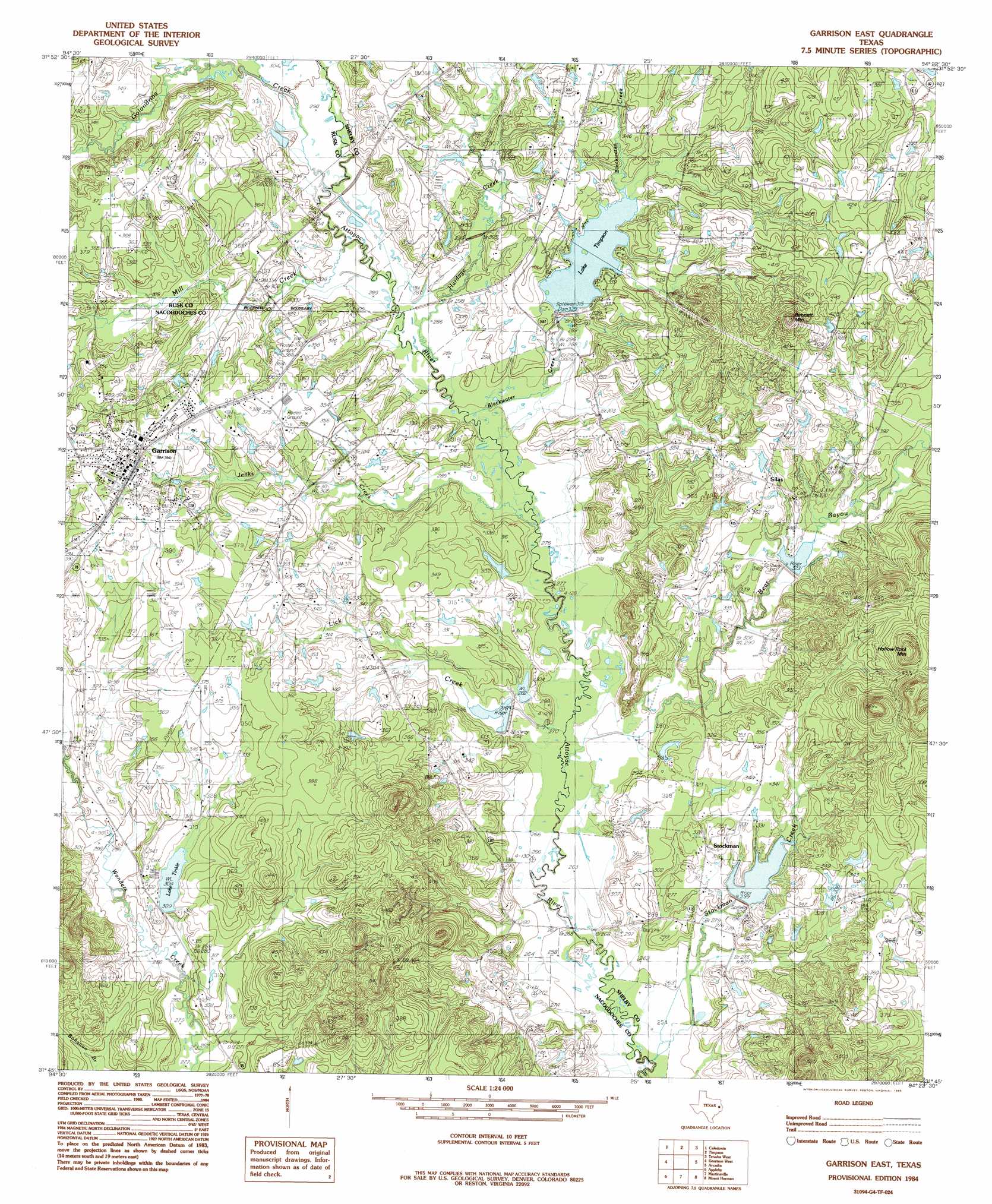
Garrison East Topo Map Texas
To zoom in, hover over the map of Garrison East
USGS Topo Quad 31094g4 - 1:24,000 scale
| Topo Map Name: | Garrison East |
| USGS Topo Quad ID: | 31094g4 |
| Print Size: | ca. 21 1/4" wide x 27" high |
| Southeast Coordinates: | 31.75° N latitude / 94.375° W longitude |
| Map Center Coordinates: | 31.8125° N latitude / 94.4375° W longitude |
| U.S. State: | TX |
| Filename: | o31094g4.jpg |
| Download Map JPG Image: | Garrison East topo map 1:24,000 scale |
| Map Type: | Topographic |
| Topo Series: | 7.5´ |
| Map Scale: | 1:24,000 |
| Source of Map Images: | United States Geological Survey (USGS) |
| Alternate Map Versions: |
Garrison East TX 1984, updated 1985 Download PDF Buy paper map Garrison East TX 2010 Download PDF Buy paper map Garrison East TX 2013 Download PDF Buy paper map Garrison East TX 2016 Download PDF Buy paper map |
1:24,000 Topo Quads surrounding Garrison East
Minden |
Long Branch |
Lake Murvaul |
Gary |
Old Center |
Mount Enterprise |
Caledonia |
Timpson |
Tenaha West |
Tenaha East |
Trawick |
Garrison West |
Garrison East |
Arcadia |
Center |
Nacogdoches North |
Appleby |
Martinsville |
Mount Herman |
Neuville |
Nacogdoches South |
Woden |
Melrose |
Chireno North |
San Augustine West |
> Back to 31094e1 at 1:100,000 scale
> Back to 31094a1 at 1:250,000 scale
> Back to U.S. Topo Maps home
Garrison East topo map: Gazetteer
Garrison East: Airports
Barton Memorial Airport elevation 103m 337′R D Williams Airport elevation 97m 318′
Garrison East: Dams
Lake Timpson Dam elevation 98m 321′Lake Tinkle Dam elevation 93m 305′
Soil Conservation Service Site 11 Dam elevation 104m 341′
Soil Conservation Service Site 12 Dam elevation 87m 285′
Soil Conservation Service Site 18a Dam elevation 89m 291′
Garrison East: Populated Places
Garrison elevation 119m 390′Silas elevation 110m 360′
Stockman elevation 102m 334′
Garrison East: Reservoirs
Lake Timpson elevation 97m 318′Lake Tinkle elevation 93m 305′
Soil Conservation Service Site 11 Reservoir elevation 104m 341′
Soil Conservation Service Site 12 Reservoir elevation 87m 285′
Soil Conservation Service Site 18a Reservoir elevation 89m 291′
Garrison East: Streams
Bear Bayou elevation 82m 269′Blackwater Creek elevation 85m 278′
Caney Creek elevation 93m 305′
Golondrina Creek elevation 89m 291′
Hardage Creek elevation 86m 282′
Jenks Creek elevation 84m 275′
Lick Creek elevation 81m 265′
Mill Creek elevation 88m 288′
Stockman Creek elevation 76m 249′
Garrison East: Summits
Bennett Mountain elevation 159m 521′Hollow Rock Mountain elevation 172m 564′
Garrison East digital topo map on disk
Buy this Garrison East topo map showing relief, roads, GPS coordinates and other geographical features, as a high-resolution digital map file on DVD: