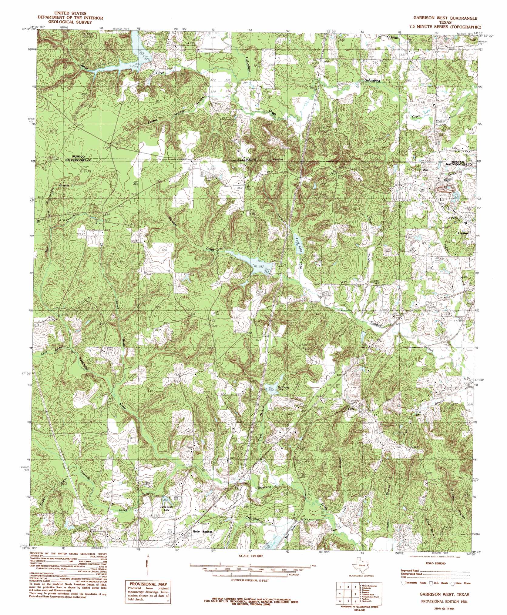
Garrison West Topo Map Texas
To zoom in, hover over the map of Garrison West
USGS Topo Quad 31094g5 - 1:24,000 scale
| Topo Map Name: | Garrison West |
| USGS Topo Quad ID: | 31094g5 |
| Print Size: | ca. 21 1/4" wide x 27" high |
| Southeast Coordinates: | 31.75° N latitude / 94.5° W longitude |
| Map Center Coordinates: | 31.8125° N latitude / 94.5625° W longitude |
| U.S. State: | TX |
| Filename: | o31094g5.jpg |
| Download Map JPG Image: | Garrison West topo map 1:24,000 scale |
| Map Type: | Topographic |
| Topo Series: | 7.5´ |
| Map Scale: | 1:24,000 |
| Source of Map Images: | United States Geological Survey (USGS) |
| Alternate Map Versions: |
Garrison West TX 1984, updated 1985 Download PDF Buy paper map Garrison West TX 2010 Download PDF Buy paper map Garrison West TX 2013 Download PDF Buy paper map Garrison West TX 2016 Download PDF Buy paper map |
1:24,000 Topo Quads surrounding Garrison West
Berryhill Creek |
Minden |
Long Branch |
Lake Murvaul |
Gary |
Laneville |
Mount Enterprise |
Caledonia |
Timpson |
Tenaha West |
Cushing |
Trawick |
Garrison West |
Garrison East |
Arcadia |
Lake Nacogdoches North |
Nacogdoches North |
Appleby |
Martinsville |
Mount Herman |
Lake Nacogdoches South |
Nacogdoches South |
Woden |
Melrose |
Chireno North |
> Back to 31094e1 at 1:100,000 scale
> Back to 31094a1 at 1:250,000 scale
> Back to U.S. Topo Maps home
Garrison West topo map: Gazetteer
Garrison West: Dams
Ford Lake Dam elevation 119m 390′McKinney Lake Dam elevation 113m 370′
Soil Conservation Service Site 20 Dam elevation 117m 383′
Soil Conservation Service Site 3 Dam elevation 129m 423′
Garrison West: Populated Places
Fitze elevation 140m 459′Holly Springs elevation 122m 400′
Whispering Pines elevation 150m 492′
Garrison West: Reservoirs
Curtis Smith Lake elevation 108m 354′Ford Lake elevation 118m 387′
McKinney Lake elevation 111m 364′
Soil Conservation Service Site 20 Reservoir elevation 117m 383′
Soil Conservation Service Site 3 Reservoir elevation 129m 423′
Garrison West: Springs
Bellevue Spring elevation 158m 518′Tonkawa Spring elevation 142m 465′
White and Red Springs elevation 111m 364′
Garrison West: Streams
Burnt Schoolhouse Branch elevation 121m 396′Case Branch elevation 106m 347′
Cedar Branch elevation 106m 347′
Clear Branch elevation 110m 360′
Crawford Creek elevation 91m 298′
Fenton Springs Branch elevation 113m 370′
Fitze Branch elevation 91m 298′
Indian Creek elevation 92m 301′
Mill Branch elevation 111m 364′
Mud Creek elevation 91m 298′
Sandy Creek elevation 113m 370′
Telesco Creek elevation 98m 321′
Tiger Branch elevation 95m 311′
Tucker Branch elevation 103m 337′
Village Creek elevation 101m 331′
Wolf Branch elevation 92m 301′
Garrison West digital topo map on disk
Buy this Garrison West topo map showing relief, roads, GPS coordinates and other geographical features, as a high-resolution digital map file on DVD: