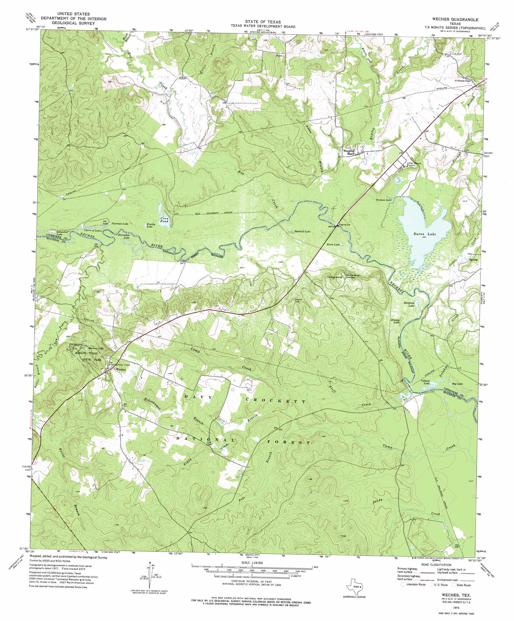
Weches Topo Map Texas
To zoom in, hover over the map of Weches
USGS Topo Quad 31095e2 - 1:24,000 scale
| Topo Map Name: | Weches |
| USGS Topo Quad ID: | 31095e2 |
| Print Size: | ca. 21 1/4" wide x 27" high |
| Southeast Coordinates: | 31.5° N latitude / 95.125° W longitude |
| Map Center Coordinates: | 31.5625° N latitude / 95.1875° W longitude |
| U.S. State: | TX |
| Filename: | o31095e2.jpg |
| Download Map JPG Image: | Weches topo map 1:24,000 scale |
| Map Type: | Topographic |
| Topo Series: | 7.5´ |
| Map Scale: | 1:24,000 |
| Source of Map Images: | United States Geological Survey (USGS) |
| Alternate Map Versions: |
Weches TX 1973, updated 1977 Download PDF Buy paper map Weches TX 1973, updated 1977 Download PDF Buy paper map Weches TX 2004, updated 2006 Download PDF Buy paper map Weches TX 2010 Download PDF Buy paper map Weches TX 2013 Download PDF Buy paper map Weches TX 2016 Download PDF Buy paper map |
| FStopo: | US Forest Service topo Weches is available: Download FStopo PDF Download FStopo TIF |
1:24,000 Topo Quads surrounding Weches
Neches |
Maydelle |
Rusk |
Atoy |
Reklaw |
Slocum |
Denson Springs |
Pryor Mountain |
Alto |
Douglas |
Percilla |
Augusta |
Weches |
Forest |
Durst Lakes |
Grapeland |
Crockett Ne |
Ratcliff |
Kennard Ne |
Wells |
Crockett |
Berea |
Kennard |
Centralia |
Wells Sw |
> Back to 31095e1 at 1:100,000 scale
> Back to 31094a1 at 1:250,000 scale
> Back to U.S. Topo Maps home
Weches topo map: Gazetteer
Weches: Bridges
SH 21 Bridge elevation 65m 213′Weches: Crossings
Kennedy Crossing elevation 65m 213′Weches: Dams
Duren Lake Dam elevation 64m 209′Weches: Lakes
Bog Lake elevation 64m 209′Bog Lake elevation 64m 209′
Brushy Lake elevation 67m 219′
Brushy Lake elevation 64m 209′
Chain of Lakes elevation 67m 219′
Chain of Lakes elevation 65m 213′
Collard Lake elevation 62m 203′
Collard Lake elevation 62m 203′
Coon Pond elevation 65m 213′
Duren Lake elevation 62m 203′
Duren Lake elevation 62m 203′
Forman Lake elevation 64m 209′
Forman Lake elevation 64m 209′
Hargrove Lake elevation 62m 203′
Hargrove Lake elevation 62m 203′
Horseshoe Lake elevation 67m 219′
Horseshoe Lake elevation 65m 213′
Krem Lake elevation 64m 209′
Krem Lake elevation 64m 209′
Mission Lake elevation 84m 275′
Mission Lake elevation 84m 275′
Pearman Lake elevation 67m 219′
Pearman Lake elevation 67m 219′
Sawmill Lake elevation 65m 213′
Sawmill Lake elevation 64m 209′
Schoechler Lake elevation 66m 216′
Schoechler Lake elevation 66m 216′
Weches: Parks
Caddoan Mounds State Historical Park elevation 85m 278′Mission Tejas State Park elevation 97m 318′
Mission Tejas State Park elevation 104m 341′
Weches: Populated Places
Bluff City (historical) elevation 61m 200′Easley Chapel elevation 114m 374′
Weches elevation 139m 456′
Weeping Mary elevation 69m 226′
Weches: Reservoirs
Duren Lake elevation 64m 209′Weches: Streams
Allen Branch elevation 64m 209′Bluff Creek elevation 66m 216′
Bluff Creek elevation 61m 200′
Bodenhamer Branch elevation 84m 275′
Bodenhamer Branch elevation 85m 278′
Boggy Glade Branch elevation 75m 246′
Boggy Glade Branch elevation 75m 246′
Bowles Creek elevation 63m 206′
Bowles Creek elevation 63m 206′
Box Creek elevation 64m 209′
Butler Branch elevation 70m 229′
Cedar Creek elevation 63m 206′
Forman Branch elevation 62m 203′
Musek Branch elevation 73m 239′
Pole Branch elevation 73m 239′
Pole Branch elevation 73m 239′
San Pedro Creek elevation 67m 219′
San Pedro Creek elevation 67m 219′
Sulphur Creek elevation 60m 196′
White Oak Creek elevation 70m 229′
White Oak Creek elevation 70m 229′
Weches: Trails
Mission Tejas State Park Trail elevation 104m 341′Neches Bluff Trail elevation 112m 367′
Weches digital topo map on disk
Buy this Weches topo map showing relief, roads, GPS coordinates and other geographical features, as a high-resolution digital map file on DVD: