Southwest Palestine Topo Map Texas
To zoom in, hover over the map of Southwest Palestine
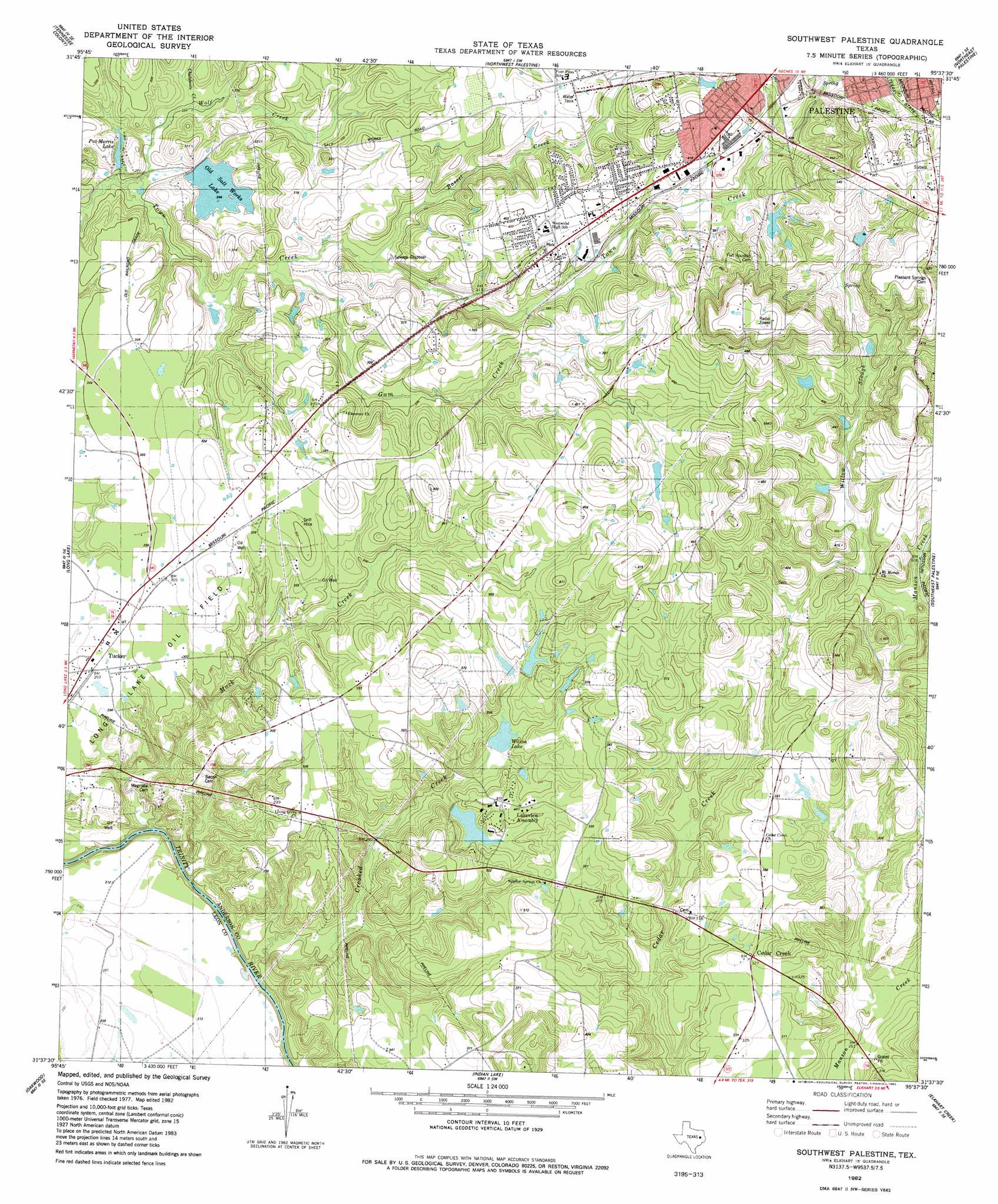
USGS Topo Quad 31095f6 - 1:24,000 scale
| Topo Map Name: | Southwest Palestine |
| USGS Topo Quad ID: | 31095f6 |
| Print Size: | ca. 21 1/4" wide x 27" high |
| Southeast Coordinates: | 31.625° N latitude / 95.625° W longitude |
| Map Center Coordinates: | 31.6875° N latitude / 95.6875° W longitude |
| U.S. State: | TX |
| Filename: | o31095f6.jpg |
| Download Map JPG Image: | Southwest Palestine topo map 1:24,000 scale |
| Map Type: | Topographic |
| Topo Series: | 7.5´ |
| Map Scale: | 1:24,000 |
| Source of Map Images: | United States Geological Survey (USGS) |
| Alternate Map Versions: |
Southwest Palestine TX 1982, updated 1982 Download PDF Buy paper map Southwest Palestine TX 2010 Download PDF Buy paper map Southwest Palestine TX 2013 Download PDF Buy paper map Southwest Palestine TX 2016 Download PDF Buy paper map |
1:24,000 Topo Quads surrounding Southwest Palestine
Cayuga |
Blackfoot |
Wilkerson Mountain |
Pert |
Todd City |
Yard |
Tennessee Colony |
Northwest Palestine |
Northeast Palestine |
Neches |
Butler |
Long Lake |
Southwest Palestine |
Southeast Palestine |
Slocum |
Keechi |
Oakwood |
Indian Lake |
Elkhart Creek |
Percilla |
Flo |
Lake Leon |
Stanmire Lake |
Hays Spring |
Grapeland |
> Back to 31095e1 at 1:100,000 scale
> Back to 31094a1 at 1:250,000 scale
> Back to U.S. Topo Maps home
Southwest Palestine topo map: Gazetteer
Southwest Palestine: Dams
Duggeys Lake Dam elevation 75m 246′Gooch Lake Dam elevation 114m 374′
Lakeview Methodist Lake Dam elevation 86m 282′
Pat Morris Dam elevation 78m 255′
Wilson Lake Dam elevation 87m 285′
Southwest Palestine: Lakes
Old Salt Works Lake elevation 74m 242′Pat Morris Lake elevation 77m 252′
Wilson Lake elevation 89m 291′
Southwest Palestine: Oilfields
Long Lake Oil Field elevation 92m 301′Southwest Palestine: Populated Places
Lakeview Assembly elevation 96m 314′Tucker elevation 89m 291′
Southwest Palestine: Reservoirs
Gooch Lake elevation 114m 374′Lakeview Methodist Lake elevation 86m 282′
Pat Morris Lake elevation 78m 255′
Wilson Lake elevation 87m 285′
Southwest Palestine: Streams
Basset Creek elevation 84m 275′Chalybeate Creek elevation 77m 252′
Crooked Creek elevation 56m 183′
Gum Creek elevation 80m 262′
Mack Creek elevation 53m 173′
Willow Slough elevation 95m 311′
Wolf Creek elevation 72m 236′
Southwest Palestine digital topo map on disk
Buy this Southwest Palestine topo map showing relief, roads, GPS coordinates and other geographical features, as a high-resolution digital map file on DVD: