Todd City Topo Map Texas
To zoom in, hover over the map of Todd City
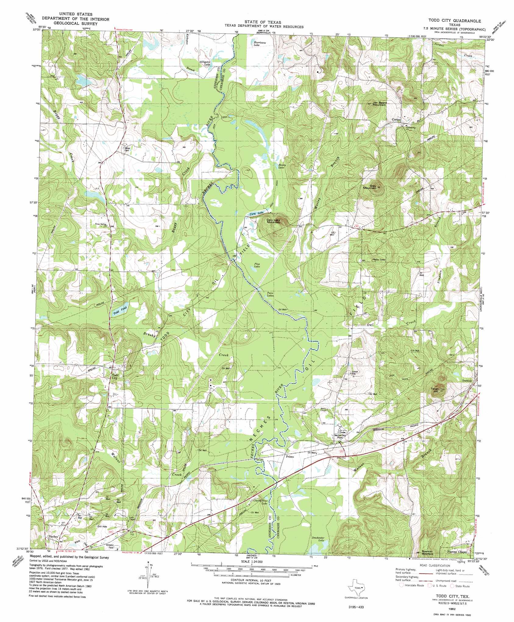
USGS Topo Quad 31095h4 - 1:24,000 scale
| Topo Map Name: | Todd City |
| USGS Topo Quad ID: | 31095h4 |
| Print Size: | ca. 21 1/4" wide x 27" high |
| Southeast Coordinates: | 31.875° N latitude / 95.375° W longitude |
| Map Center Coordinates: | 31.9375° N latitude / 95.4375° W longitude |
| U.S. State: | TX |
| Filename: | o31095h4.jpg |
| Download Map JPG Image: | Todd City topo map 1:24,000 scale |
| Map Type: | Topographic |
| Topo Series: | 7.5´ |
| Map Scale: | 1:24,000 |
| Source of Map Images: | United States Geological Survey (USGS) |
| Alternate Map Versions: |
Todd City TX 1982, updated 1982 Download PDF Buy paper map Todd City TX 2010 Download PDF Buy paper map Todd City TX 2013 Download PDF Buy paper map Todd City TX 2016 Download PDF Buy paper map |
1:24,000 Topo Quads surrounding Todd City
Leagueville |
Moore Station |
Saline Bay |
Bullard |
Troup West |
La Rue |
Poynor |
Berryville |
Mount Selman |
Tecula |
Wilkerson Mountain |
Pert |
Todd City |
Jacksonville West |
Jacksonville East |
Northwest Palestine |
Northeast Palestine |
Neches |
Maydelle |
Rusk |
Southwest Palestine |
Southeast Palestine |
Slocum |
Denson Springs |
Pryor Mountain |
> Back to 31095e1 at 1:100,000 scale
> Back to 31094a1 at 1:250,000 scale
> Back to U.S. Topo Maps home
Todd City topo map: Gazetteer
Todd City: Lakes
Alligator Lake elevation 89m 291′Cary Lake elevation 95m 311′
Henry Lake elevation 88m 288′
Hurricane Lake elevation 89m 291′
Pine Lake elevation 86m 282′
Twin Lakes elevation 85m 278′
Todd City: Oilfields
Neches Oil Field elevation 85m 278′Todd City Oil Field elevation 102m 334′
Todd City: Populated Places
Corine elevation 135m 442′Pierces Chapel elevation 139m 456′
Prices elevation 85m 278′
Todd City elevation 141m 462′
Todd City: Streams
Boggy Creek elevation 88m 288′Brushy Creek elevation 85m 278′
Kickapoo Branch elevation 89m 291′
Owl Creek elevation 85m 278′
Simpson Branch elevation 96m 314′
Walnut Creek elevation 85m 278′
Worley Branch elevation 85m 278′
Todd City: Summits
Bowman Mountain elevation 197m 646′Cary Lake Mountain elevation 137m 449′
Gray Mountain elevation 209m 685′
Jim Beard Mountain elevation 141m 462′
Tater Hill elevation 168m 551′
Todd City digital topo map on disk
Buy this Todd City topo map showing relief, roads, GPS coordinates and other geographical features, as a high-resolution digital map file on DVD: