Turlington Topo Map Texas
To zoom in, hover over the map of Turlington
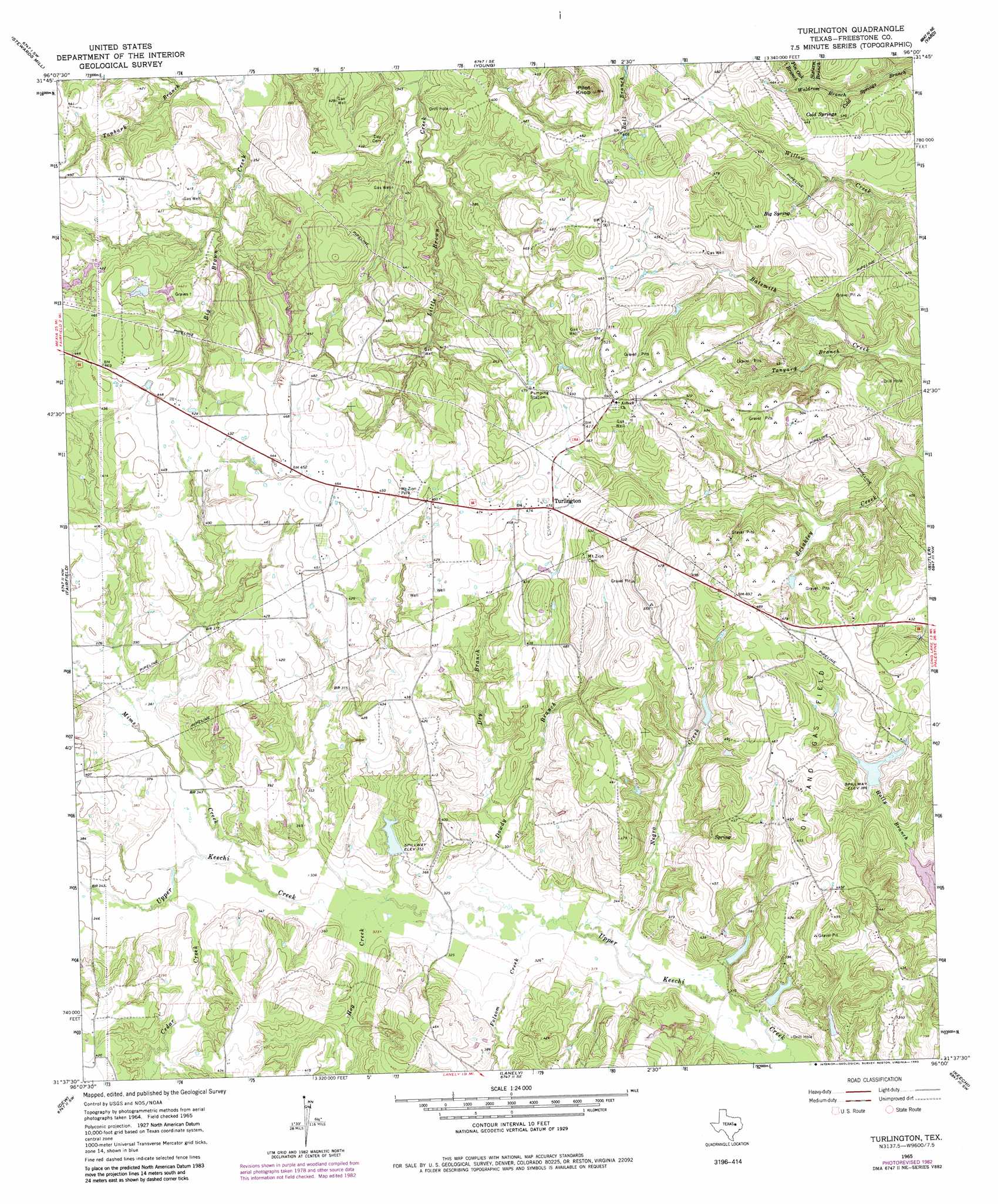
USGS Topo Quad 31096f1 - 1:24,000 scale
| Topo Map Name: | Turlington |
| USGS Topo Quad ID: | 31096f1 |
| Print Size: | ca. 21 1/4" wide x 27" high |
| Southeast Coordinates: | 31.625° N latitude / 96° W longitude |
| Map Center Coordinates: | 31.6875° N latitude / 96.0625° W longitude |
| U.S. State: | TX |
| Filename: | o31096f1.jpg |
| Download Map JPG Image: | Turlington topo map 1:24,000 scale |
| Map Type: | Topographic |
| Topo Series: | 7.5´ |
| Map Scale: | 1:24,000 |
| Source of Map Images: | United States Geological Survey (USGS) |
| Alternate Map Versions: |
Turlington TX 1965, updated 1968 Download PDF Buy paper map Turlington TX 1965, updated 1983 Download PDF Buy paper map Turlington TX 2010 Download PDF Buy paper map Turlington TX 2013 Download PDF Buy paper map Turlington TX 2016 Download PDF Buy paper map |
1:24,000 Topo Quads surrounding Turlington
Streetman |
Winkler |
Roustabout Camp |
Cayuga |
Blackfoot |
Kirvin |
Stewards Mill |
Young |
Yard |
Tennessee Colony |
Teague North |
Fairfield |
Turlington |
Butler |
Long Lake |
Teague South |
Dew |
Lanely |
Keechi |
Oakwood |
Farrar |
Donie |
Buffalo |
Flo |
Lake Leon |
> Back to 31096e1 at 1:100,000 scale
> Back to 31096a1 at 1:250,000 scale
> Back to U.S. Topo Maps home
Turlington topo map: Gazetteer
Turlington: Dams
Blackbird Lake Dam elevation 105m 344′Hogshead Lake Dam elevation 109m 357′
Morse Lake Dam elevation 118m 387′
Richards Lake Dam elevation 105m 344′
Wilson Lake Dam elevation 103m 337′
Turlington: Parks
Mount Zion Park elevation 138m 452′Turlington: Populated Places
Turlington elevation 146m 479′Turlington: Reservoirs
Blackbird Lake elevation 105m 344′Hogshead Lake elevation 109m 357′
Morse Lake elevation 118m 387′
Richards Lake elevation 105m 344′
Wilson Lake elevation 103m 337′
Turlington: Springs
Big Spring elevation 129m 423′Cold Springs elevation 114m 374′
Turlington: Streams
Cedar Creek elevation 104m 341′Dowdy Branch elevation 97m 318′
Dry Branch elevation 102m 334′
Folsom Creek elevation 97m 318′
Hog Creek elevation 98m 321′
Mims Creek elevation 101m 331′
Negro Creek elevation 95m 311′
Pin Oak Branch elevation 113m 370′
Sistern Branch elevation 110m 360′
Tanbark Branch elevation 101m 331′
Tanyard Branch elevation 105m 344′
Waldrom Branch elevation 101m 331′
Turlington: Summits
Pilot Knob elevation 172m 564′Turlington digital topo map on disk
Buy this Turlington topo map showing relief, roads, GPS coordinates and other geographical features, as a high-resolution digital map file on DVD: