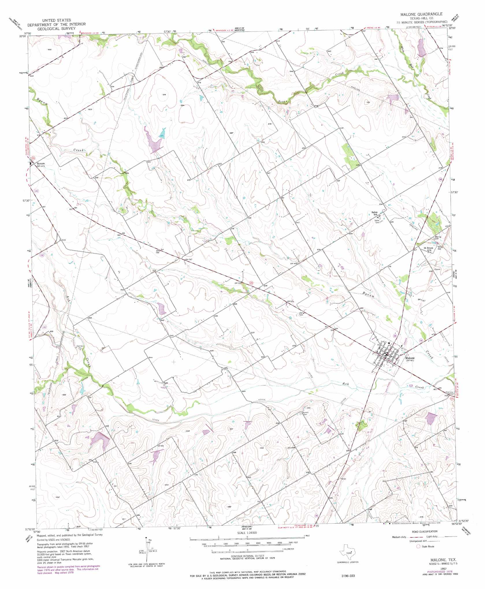
Malone Topo Map Texas
To zoom in, hover over the map of Malone
USGS Topo Quad 31096h8 - 1:24,000 scale
| Topo Map Name: | Malone |
| USGS Topo Quad ID: | 31096h8 |
| Print Size: | ca. 21 1/4" wide x 27" high |
| Southeast Coordinates: | 31.875° N latitude / 96.875° W longitude |
| Map Center Coordinates: | 31.9375° N latitude / 96.9375° W longitude |
| U.S. State: | TX |
| Filename: | o31096h8.jpg |
| Download Map JPG Image: | Malone topo map 1:24,000 scale |
| Map Type: | Topographic |
| Topo Series: | 7.5´ |
| Map Scale: | 1:24,000 |
| Source of Map Images: | United States Geological Survey (USGS) |
| Alternate Map Versions: |
Malone TX 1957, updated 1958 Download PDF Buy paper map Malone TX 1957, updated 1978 Download PDF Buy paper map Malone TX 2010 Download PDF Buy paper map Malone TX 2013 Download PDF Buy paper map Malone TX 2016 Download PDF Buy paper map |
1:24,000 Topo Quads surrounding Malone
Itasca |
Files Valley |
Italy |
Avalon |
Cryer Creek |
Hillsboro West |
Hillsboro East |
Mertens |
Frost |
Blooming Grove |
Peoria |
Abbott |
Malone |
Irene |
Dawson |
Aquilla |
West |
Penelope |
Hubbard |
Coolidge |
Gholson |
Elm Mott |
Axtell |
Prairie Hill |
Echols |
> Back to 31096e1 at 1:100,000 scale
> Back to 31096a1 at 1:250,000 scale
> Back to U.S. Topo Maps home
Malone topo map: Gazetteer
Malone: Dams
Kempshafer Lake Dam elevation 165m 541′Soil Conservation Service Site 58 Dam elevation 147m 482′
Soil Conservation Service Site 65 Dam elevation 162m 531′
Soil Conservation Service Site 66 Dam elevation 150m 492′
Soil Conservation Service Site 68 Dam elevation 168m 551′
Soil Conservation Service Site 71a Dam elevation 157m 515′
Soil Conservation Service Site 80 Dam elevation 163m 534′
Soil Conservation Service Site 81 Dam elevation 159m 521′
Soil Conservation Service Site 82 Dam elevation 154m 505′
Soil Conservation Service Site 83 Dam elevation 150m 492′
Soil Conservation Service Site 86 Dam elevation 147m 482′
Soil Conservation Service Site 88 Dam elevation 143m 469′
Malone: Populated Places
Malone elevation 146m 479′Malone: Reservoirs
Kempshafer Lake elevation 165m 541′Soil Conservation Service Site 58 Reservoir elevation 147m 482′
Soil Conservation Service Site 65 Reservoir elevation 162m 531′
Soil Conservation Service Site 66 Reservoir elevation 150m 492′
Soil Conservation Service Site 68 Reservoir elevation 168m 551′
Soil Conservation Service Site 71a Reservoir elevation 157m 515′
Soil Conservation Service Site 80 Reservoir elevation 163m 534′
Soil Conservation Service Site 81 Reservoir elevation 159m 521′
Soil Conservation Service Site 82 Reservoir elevation 154m 505′
Soil Conservation Service Site 83 Reservoir elevation 150m 492′
Soil Conservation Service Site 86 Reservoir elevation 147m 482′
Soil Conservation Service Site 88 Reservoir elevation 143m 469′
Malone: Streams
Pecan Creek elevation 143m 469′Malone digital topo map on disk
Buy this Malone topo map showing relief, roads, GPS coordinates and other geographical features, as a high-resolution digital map file on DVD: