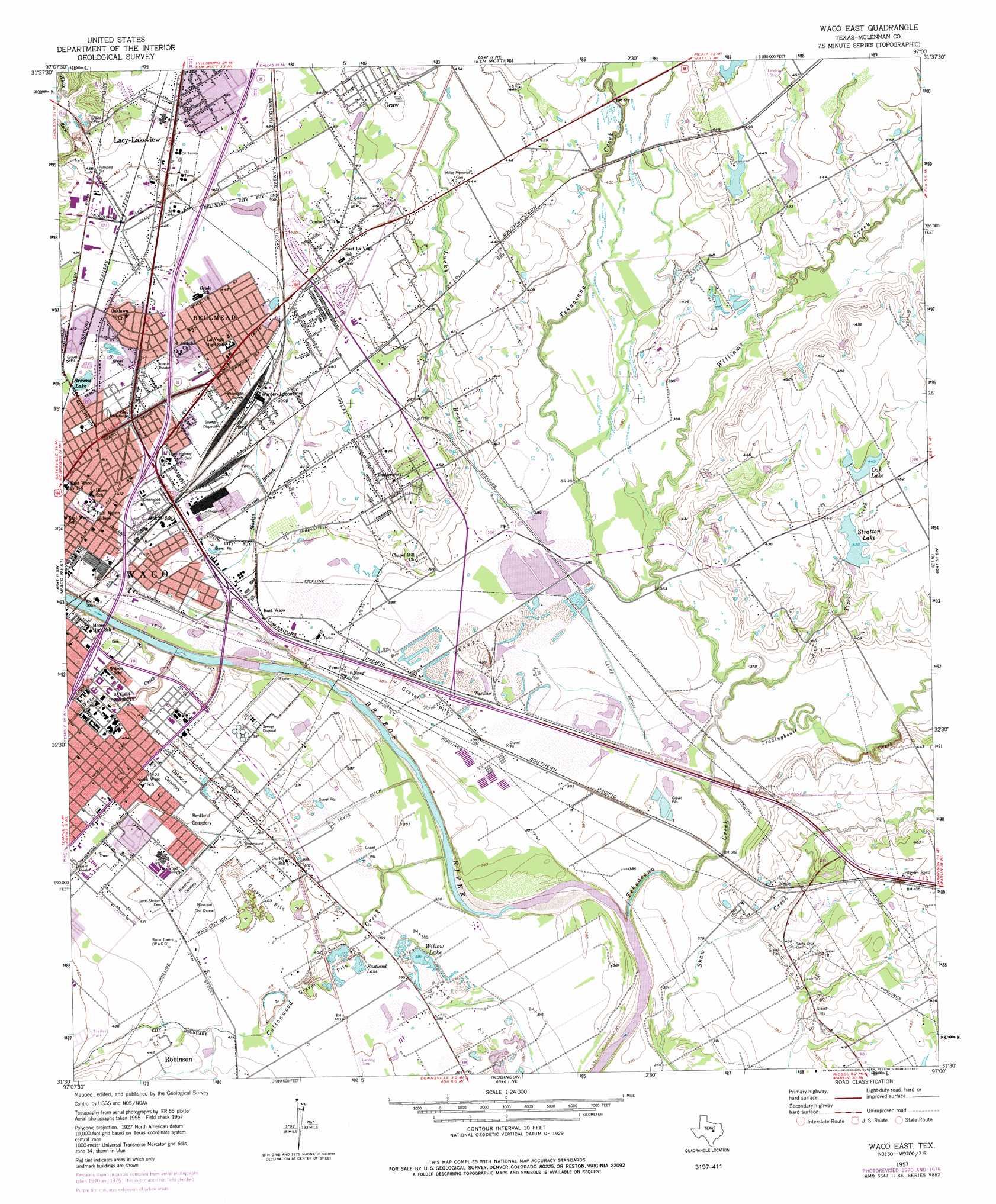
Waco East Topo Map Texas
To zoom in, hover over the map of Waco East
USGS Topo Quad 31097e1 - 1:24,000 scale
| Topo Map Name: | Waco East |
| USGS Topo Quad ID: | 31097e1 |
| Print Size: | ca. 21 1/4" wide x 27" high |
| Southeast Coordinates: | 31.5° N latitude / 97° W longitude |
| Map Center Coordinates: | 31.5625° N latitude / 97.0625° W longitude |
| U.S. State: | TX |
| Filename: | o31097e1.jpg |
| Download Map JPG Image: | Waco East topo map 1:24,000 scale |
| Map Type: | Topographic |
| Topo Series: | 7.5´ |
| Map Scale: | 1:24,000 |
| Source of Map Images: | United States Geological Survey (USGS) |
| Alternate Map Versions: |
Waco East TX 1957, updated 1958 Download PDF Buy paper map Waco East TX 1957, updated 1971 Download PDF Buy paper map Waco East TX 1957, updated 1977 Download PDF Buy paper map Waco East TX 2010 Download PDF Buy paper map Waco East TX 2012 Download PDF Buy paper map Waco East TX 2016 Download PDF Buy paper map |
1:24,000 Topo Quads surrounding Waco East
Smiths Bend |
Aquilla |
West |
Penelope |
Hubbard |
China Springs |
Gholson |
Elm Mott |
Axtell |
Prairie Hill |
Speegleville |
Waco West |
Waco East |
Elk |
Mart |
South Bosque |
Lorena |
Robinson |
Riesel |
Otto |
Moody |
Bruceville |
Chilton |
Marlin |
Mcclanahan |
> Back to 31097e1 at 1:100,000 scale
> Back to 31096a1 at 1:250,000 scale
> Back to U.S. Topo Maps home
Waco East topo map: Gazetteer
Waco East: Airports
Flying Heart Ranch Airport elevation 122m 400′Sheriff Department Heliport elevation 117m 383′
Wings for Christ International Flight Academy Airport elevation 138m 452′
Young Brothers Heliport elevation 119m 390′
Waco East: Crossings
Potts Interchange elevation 125m 410′Waco East: Dams
Lake Brazos Dam elevation 116m 380′Oak Lake Dam elevation 135m 442′
Patterson Dam elevation 124m 406′
W O Gross Jr Dam elevation 133m 436′
Yowell Lake Dam elevation 135m 442′
Waco East: Lakes
Browns Lake elevation 124m 406′Waco East: Parks
Baylor Ballpark elevation 119m 390′Betty Lou Mays Soccer Field elevation 119m 390′
Buena Vista Park elevation 134m 439′
Lions Park elevation 134m 439′
The Ferrell Center elevation 119m 390′
Waco East: Populated Places
Bellmead elevation 133m 436′East Waco elevation 119m 390′
Neale elevation 125m 410′
Oaklake elevation 141m 462′
Ocaw elevation 140m 459′
Vemo elevation 118m 387′
Wardlaw elevation 117m 383′
Waco East: Reservoirs
Eastland Lake elevation 119m 390′Gross Lake elevation 133m 436′
Lake Brazos elevation 116m 380′
Oak Lake elevation 135m 442′
Stratton Lake elevation 128m 419′
Willow Lake elevation 119m 390′
Yowell Lake elevation 135m 442′
Waco East: Streams
Cottonwood Creek elevation 109m 357′Kirkland Branch elevation 122m 400′
Lucky Branch elevation 115m 377′
Marlin Branch elevation 117m 383′
Tehuacana Creek elevation 111m 364′
Tiger Creek elevation 109m 357′
Tradinghouse Creek elevation 109m 357′
Waco Creek elevation 109m 357′
Williams Creek elevation 111m 364′
Waco East digital topo map on disk
Buy this Waco East topo map showing relief, roads, GPS coordinates and other geographical features, as a high-resolution digital map file on DVD: