China Springs Topo Map Texas
To zoom in, hover over the map of China Springs
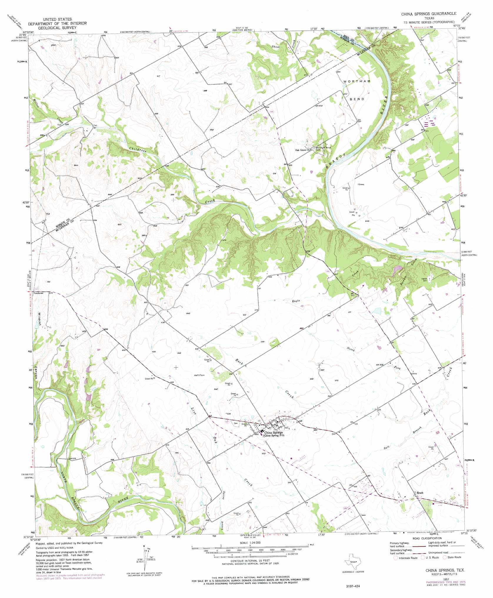
USGS Topo Quad 31097f3 - 1:24,000 scale
| Topo Map Name: | China Springs |
| USGS Topo Quad ID: | 31097f3 |
| Print Size: | ca. 21 1/4" wide x 27" high |
| Southeast Coordinates: | 31.625° N latitude / 97.25° W longitude |
| Map Center Coordinates: | 31.6875° N latitude / 97.3125° W longitude |
| U.S. State: | TX |
| Filename: | o31097f3.jpg |
| Download Map JPG Image: | China Springs topo map 1:24,000 scale |
| Map Type: | Topographic |
| Topo Series: | 7.5´ |
| Map Scale: | 1:24,000 |
| Source of Map Images: | United States Geological Survey (USGS) |
| Alternate Map Versions: |
China Springs TX 1957, updated 1958 Download PDF Buy paper map China Springs TX 1957, updated 1968 Download PDF Buy paper map China Springs TX 1957, updated 1971 Download PDF Buy paper map China Springs TX 1957, updated 1977 Download PDF Buy paper map China Springs TX 2010 Download PDF Buy paper map China Springs TX 2012 Download PDF Buy paper map China Springs TX 2016 Download PDF Buy paper map |
1:24,000 Topo Quads surrounding China Springs
Pilot Knob |
Allen Bend |
Whitney |
Peoria |
Abbott |
Clifton |
Laguna Park |
Smiths Bend |
Aquilla |
West |
Mosheim |
Valley Mills |
China Springs |
Gholson |
Elm Mott |
Coryell |
Crawford |
Speegleville |
Waco West |
Waco East |
Oglesby |
Mcgregor |
South Bosque |
Lorena |
Robinson |
> Back to 31097e1 at 1:100,000 scale
> Back to 31096a1 at 1:250,000 scale
> Back to U.S. Topo Maps home
China Springs topo map: Gazetteer
China Springs: Airports
Pocock Airport elevation 173m 567′Wildcat Canyon Strip elevation 200m 656′
China Springs: Bends
Wortham Bend elevation 138m 452′China Springs: Dams
Mahoney Lake Dam elevation 133m 436′Mahoney South Lake Dam elevation 159m 521′
Thompson Lake Dam elevation 169m 554′
China Springs: Populated Places
China Springs elevation 187m 613′Erath elevation 168m 551′
China Springs: Post Offices
China Spring Post Office elevation 187m 613′China Springs: Reservoirs
Mahoney Lake elevation 133m 436′Mahoney South Lake elevation 159m 521′
Thompson Lake elevation 169m 554′
China Springs: Springs
El Flechazo Spring elevation 162m 531′China Springs: Streams
Childress Creek elevation 122m 400′Eagle Creek elevation 119m 390′
North Fork Rock Creek elevation 142m 465′
Possum Creek elevation 119m 390′
Salt Branch elevation 143m 469′
Willow Creek elevation 158m 518′
China Springs digital topo map on disk
Buy this China Springs topo map showing relief, roads, GPS coordinates and other geographical features, as a high-resolution digital map file on DVD: