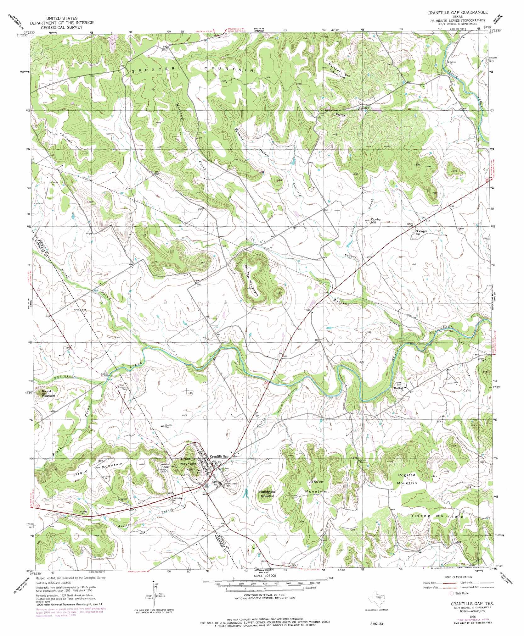
Cranfills Gap Topo Map Texas
To zoom in, hover over the map of Cranfills Gap
USGS Topo Quad 31097g7 - 1:24,000 scale
| Topo Map Name: | Cranfills Gap |
| USGS Topo Quad ID: | 31097g7 |
| Print Size: | ca. 21 1/4" wide x 27" high |
| Southeast Coordinates: | 31.75° N latitude / 97.75° W longitude |
| Map Center Coordinates: | 31.8125° N latitude / 97.8125° W longitude |
| U.S. State: | TX |
| Filename: | o31097g7.jpg |
| Download Map JPG Image: | Cranfills Gap topo map 1:24,000 scale |
| Map Type: | Topographic |
| Topo Series: | 7.5´ |
| Map Scale: | 1:24,000 |
| Source of Map Images: | United States Geological Survey (USGS) |
| Alternate Map Versions: |
Cranfills Gap TX 1956, updated 1957 Download PDF Buy paper map Cranfills Gap TX 1956, updated 1973 Download PDF Buy paper map Cranfills Gap TX 1956, updated 1984 Download PDF Buy paper map Cranfills Gap TX 2010 Download PDF Buy paper map Cranfills Gap TX 2012 Download PDF Buy paper map Cranfills Gap TX 2016 Download PDF Buy paper map |
1:24,000 Topo Quads surrounding Cranfills Gap
Clairette |
Camp Branch |
Walnut Springs West |
Walnut Springs East |
Morgan |
Hico |
Spring Creek Gap |
Iredell |
Meridian |
Pilot Knob |
Eidson Lake |
Fairy |
Cranfills Gap |
Sugarloaf Mountain |
Clifton |
Hamilton East |
Cutoff Mountain |
German Valley |
Hurst Spring |
Mosheim |
Ohio |
Jonesboro |
Ater |
Turnersville |
Coryell |
> Back to 31097e1 at 1:100,000 scale
> Back to 31096a1 at 1:250,000 scale
> Back to U.S. Topo Maps home
Cranfills Gap topo map: Gazetteer
Cranfills Gap: Airports
Cade Field elevation 351m 1151′Parrish Airstrip elevation 273m 895′
Cranfills Gap: Gaps
Cranfills Gap elevation 326m 1069′Cranfills Gap: Lakes
The Baptism Hole elevation 287m 941′Cranfills Gap: Populated Places
Cranfills Gap elevation 295m 967′Cranfills Gap: Springs
Pierson Spring elevation 279m 915′Cranfills Gap: Streams
Austin Branch elevation 262m 859′Camfield Branch elevation 261m 856′
Dunlap Branch elevation 274m 898′
Mustang Creek elevation 242m 793′
North Prong Meridian Creek elevation 280m 918′
South Prong Meridan Creek elevation 292m 958′
Cranfills Gap: Summits
Cranfills Mountain elevation 344m 1128′Dunlap Hill elevation 296m 971′
Flat Top Mountain elevation 354m 1161′
Godager Hill elevation 294m 964′
Ilseng Mountain elevation 342m 1122′
Jackson Hill elevation 372m 1220′
Jenson Mountain elevation 355m 1164′
Number Six Mountain elevation 348m 1141′
Rattlesnake Mountain elevation 337m 1105′
Rogstad Mountain elevation 343m 1125′
Round Mountain elevation 366m 1200′
Spencer Mountain elevation 366m 1200′
Cranfills Gap: Valleys
Spencer Hollow elevation 292m 958′Stiffy Hollow elevation 270m 885′
Cranfills Gap digital topo map on disk
Buy this Cranfills Gap topo map showing relief, roads, GPS coordinates and other geographical features, as a high-resolution digital map file on DVD: