Lampasas Topo Map Texas
To zoom in, hover over the map of Lampasas
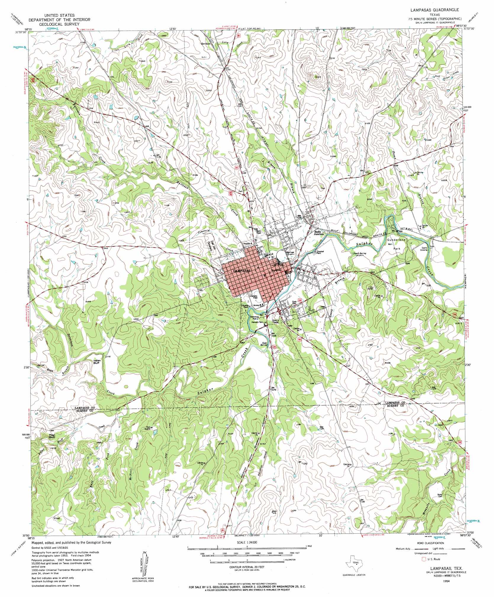
USGS Topo Quad 31098a2 - 1:24,000 scale
| Topo Map Name: | Lampasas |
| USGS Topo Quad ID: | 31098a2 |
| Print Size: | ca. 21 1/4" wide x 27" high |
| Southeast Coordinates: | 31° N latitude / 98.125° W longitude |
| Map Center Coordinates: | 31.0625° N latitude / 98.1875° W longitude |
| U.S. State: | TX |
| Filename: | o31098a2.jpg |
| Download Map JPG Image: | Lampasas topo map 1:24,000 scale |
| Map Type: | Topographic |
| Topo Series: | 7.5´ |
| Map Scale: | 1:24,000 |
| Source of Map Images: | United States Geological Survey (USGS) |
| Alternate Map Versions: |
Lampasas TX 1954, updated 1957 Download PDF Buy paper map Lampasas TX 2010 Download PDF Buy paper map Lampasas TX 2013 Download PDF Buy paper map Lampasas TX 2016 Download PDF Buy paper map |
1:24,000 Topo Quads surrounding Lampasas
Antelope Gap |
Castle Peak |
Adamsville |
Izoro |
Pidcoke |
Lometa |
Ogles |
Flat Top Peak |
Rumley |
Twin Mountains |
Gorman Falls |
Nix |
Lampasas |
Kempner |
Copperas Cove |
Tow |
Naruna |
Lake Victor |
Bachelor Peak |
Briggs |
Lake Buchanan |
Council Creek |
Burnet |
Joppa |
Mahomet |
> Back to 31098a1 at 1:100,000 scale
> Back to 31098a1 at 1:250,000 scale
> Back to U.S. Topo Maps home
Lampasas topo map: Gazetteer
Lampasas: Airports
Lampasas Airport elevation 355m 1164′Lampasas: Cliffs
Indian Bluff elevation 344m 1128′Pillar Bluff elevation 350m 1148′
Lampasas: Dams
Jones Lake Dam elevation 334m 1095′Soil Conservation Service Site 4 Dam elevation 363m 1190′
Soil Conservation Service Site 5 Dam elevation 346m 1135′
Soil Conservation Service Site 6 Dam elevation 339m 1112′
Soil Conservation Service Site 7 Dam elevation 317m 1040′
Soil Conservation Service Site 8 Dam elevation 332m 1089′
Soil Conservation Service Site 9 Dam elevation 322m 1056′
Lampasas: Parks
Brooks Park elevation 311m 1020′Gunderland Park elevation 301m 987′
Hancock Park elevation 312m 1023′
Lampasas: Populated Places
Lampasas elevation 313m 1026′Radio Junction elevation 311m 1020′
Sparks Crossing elevation 293m 961′
Lampasas: Reservoirs
Jones Lake elevation 334m 1095′Soil Conservation Service Site 4 Reservoir elevation 363m 1190′
Soil Conservation Service Site 5 Reservoir elevation 346m 1135′
Soil Conservation Service Site 6 Reservoir elevation 339m 1112′
Soil Conservation Service Site 7 Reservoir elevation 317m 1040′
Soil Conservation Service Site 8 Reservoir elevation 332m 1089′
Soil Conservation Service Site 9 Reservoir elevation 322m 1056′
Lampasas: Springs
Gold Spring elevation 312m 1023′Gooch Spring elevation 301m 987′
Hancock Springs elevation 310m 1017′
Swimming Pool Spring elevation 316m 1036′
Lampasas: Streams
Bean Creek elevation 329m 1079′Burleson Creek elevation 305m 1000′
Cemetery Creek elevation 305m 1000′
East Fork Sulphur Creek elevation 329m 1079′
Espy Branch elevation 341m 1118′
Gibson Branch elevation 305m 1000′
Gooch Branch elevation 300m 984′
McNett Creek elevation 327m 1072′
Pecan Branch elevation 293m 961′
Pillar Bluff Creek elevation 335m 1099′
Lampasas digital topo map on disk
Buy this Lampasas topo map showing relief, roads, GPS coordinates and other geographical features, as a high-resolution digital map file on DVD: