San Saba Topo Map Texas
To zoom in, hover over the map of San Saba
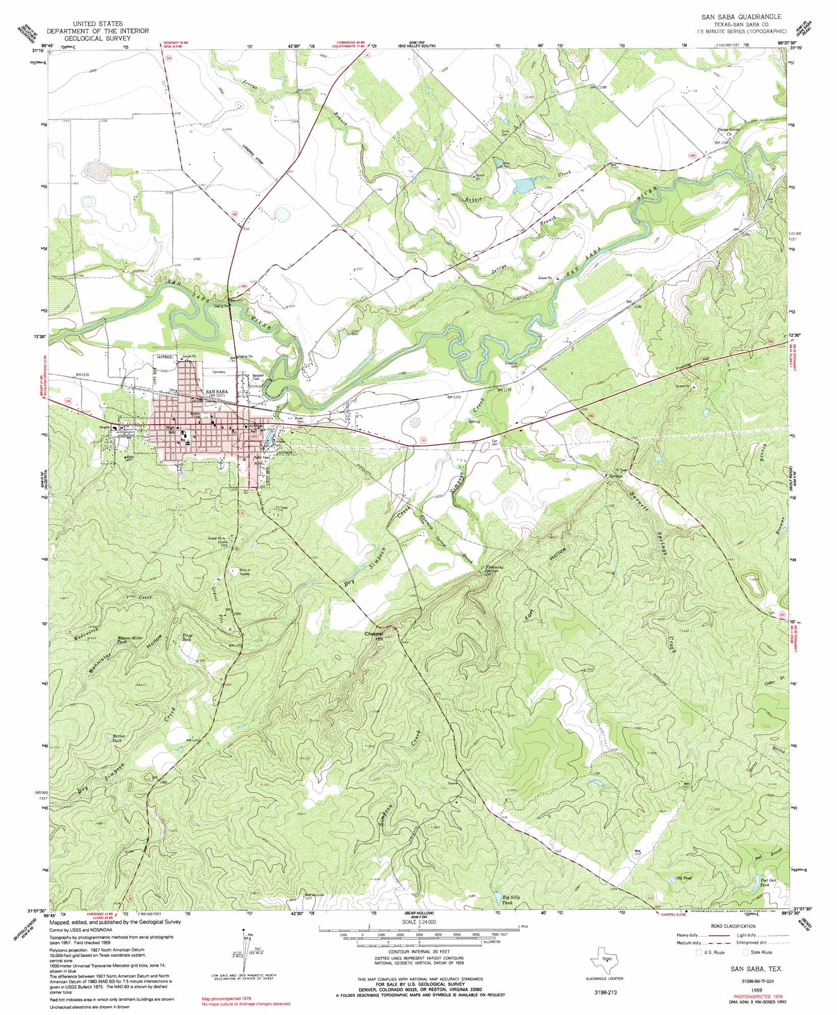
USGS Topo Quad 31098b6 - 1:24,000 scale
| Topo Map Name: | San Saba |
| USGS Topo Quad ID: | 31098b6 |
| Print Size: | ca. 21 1/4" wide x 27" high |
| Southeast Coordinates: | 31.125° N latitude / 98.625° W longitude |
| Map Center Coordinates: | 31.1875° N latitude / 98.6875° W longitude |
| U.S. State: | TX |
| Filename: | o31098b6.jpg |
| Download Map JPG Image: | San Saba topo map 1:24,000 scale |
| Map Type: | Topographic |
| Topo Series: | 7.5´ |
| Map Scale: | 1:24,000 |
| Source of Map Images: | United States Geological Survey (USGS) |
| Alternate Map Versions: |
San Saba TX 1959, updated 1960 Download PDF Buy paper map San Saba TX 1959, updated 1965 Download PDF Buy paper map San Saba TX 1959, updated 1991 Download PDF Buy paper map San Saba TX 2010 Download PDF Buy paper map San Saba TX 2013 Download PDF Buy paper map San Saba TX 2016 Download PDF Buy paper map |
1:24,000 Topo Quads surrounding San Saba
Bowser |
Regency |
Big Valley North |
Goldthwaite |
Center City |
Richland Springs |
Blucher Mountain |
Big Valley South |
San Saba Peak |
Antelope Gap |
Baker Spring |
Algerita |
San Saba |
Wolf Ridge |
Lometa |
Brady Mountain |
Buffalo Knob |
Bear Hollow |
Bend |
Gorman Falls |
Pontotoc |
Magill Mountain |
Cherokee |
Indian Hills |
Tow |
> Back to 31098a1 at 1:100,000 scale
> Back to 31098a1 at 1:250,000 scale
> Back to U.S. Topo Maps home
San Saba topo map: Gazetteer
San Saba: Airports
San Saba County Municipal Airport elevation 379m 1243′San Saba: Dams
Ratliff Lake Dam elevation 361m 1184′San Saba: Lakes
Old Pond elevation 468m 1535′San Saba: Parks
San Saba City Park elevation 373m 1223′San Saba: Populated Places
San Saba elevation 367m 1204′San Saba: Reservoirs
Barker Tank elevation 432m 1417′Big Sally Tank elevation 476m 1561′
Post Oak Tank elevation 448m 1469′
Ratliff Lake elevation 361m 1184′
Tripp Tank elevation 407m 1335′
Watson-Miller Tank elevation 425m 1394′
San Saba: Springs
Barnett Springs elevation 374m 1227′Flemming Springs elevation 388m 1272′
San Saba: Streams
Barnett Springs Creek elevation 359m 1177′Dry Simpson Creek elevation 360m 1181′
Flemming Springs Branch elevation 360m 1181′
Jerrys Branch elevation 347m 1138′
Mill Creek elevation 352m 1154′
Rabbit Creek elevation 349m 1145′
Simpson Creek elevation 353m 1158′
Wadsworth Creek elevation 372m 1220′
San Saba: Summits
Chapel Hill elevation 446m 1463′Fivemile Hill elevation 406m 1332′
San Saba: Valleys
Bannister Hollow elevation 394m 1292′Fort Hollow elevation 368m 1207′
San Saba digital topo map on disk
Buy this San Saba topo map showing relief, roads, GPS coordinates and other geographical features, as a high-resolution digital map file on DVD: