Indian Creek Topo Map Texas
To zoom in, hover over the map of Indian Creek
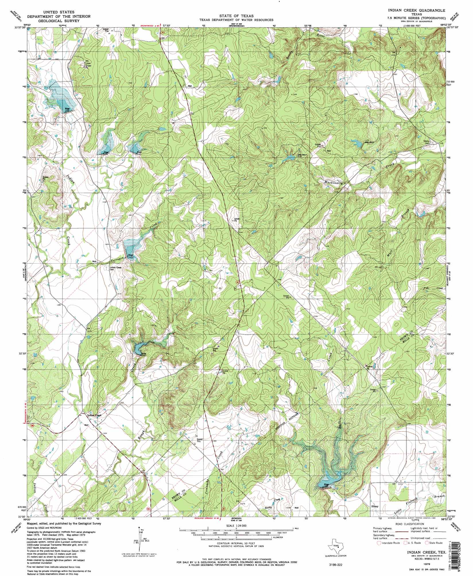
USGS Topo Quad 31098e8 - 1:24,000 scale
| Topo Map Name: | Indian Creek |
| USGS Topo Quad ID: | 31098e8 |
| Print Size: | ca. 21 1/4" wide x 27" high |
| Southeast Coordinates: | 31.5° N latitude / 98.875° W longitude |
| Map Center Coordinates: | 31.5625° N latitude / 98.9375° W longitude |
| U.S. State: | TX |
| Filename: | o31098e8.jpg |
| Download Map JPG Image: | Indian Creek topo map 1:24,000 scale |
| Map Type: | Topographic |
| Topo Series: | 7.5´ |
| Map Scale: | 1:24,000 |
| Source of Map Images: | United States Geological Survey (USGS) |
| Alternate Map Versions: |
Indian Creek TX 1979, updated 1980 Download PDF Buy paper map Indian Creek TX 1979, updated 1980 Download PDF Buy paper map Indian Creek TX 1997, updated 1998 Download PDF Buy paper map Indian Creek TX 2010 Download PDF Buy paper map Indian Creek TX 2012 Download PDF Buy paper map Indian Creek TX 2016 Download PDF Buy paper map |
1:24,000 Topo Quads surrounding Indian Creek
Thrifty |
Lake Brownwood |
Owens |
Blanket |
Mercers Gap |
Bangs West |
Bangs East |
Brownwood |
Zephyr |
Democrat |
Trickham |
Brookesmith |
Indian Creek |
Blanket Springs |
Mullin |
Mercury |
Elm Grove |
Bowser |
Regency |
Big Valley North |
Placid |
Hall |
Richland Springs |
Blucher Mountain |
Big Valley South |
> Back to 31098e1 at 1:100,000 scale
> Back to 31098a1 at 1:250,000 scale
> Back to U.S. Topo Maps home
Indian Creek topo map: Gazetteer
Indian Creek: Dams
Soil Conservation Service Site 1 Dam elevation 427m 1400′Soil Conservation Service Site 2 Dam elevation 458m 1502′
Soil Conservation Service Site 3 Dam elevation 464m 1522′
Soil Conservation Service Site 4 Dam elevation 434m 1423′
Soil Conservation Service Site 5 Dam elevation 432m 1417′
Soil Conservation Service Site 6 Dam elevation 430m 1410′
Indian Creek: Populated Places
Ebony elevation 410m 1345′Indian Creek elevation 404m 1325′
Indian Creek: Reservoirs
Brownwood Lateral Watershed Number 25 elevation 438m 1437′Northeast Lateral Watershed Number Five elevation 430m 1410′
Northeast Lateral Watershed Number Four elevation 435m 1427′
Northeast Lateral Watershed Number One elevation 443m 1453′
Northeast Lateral Watershed Number Six elevation 428m 1404′
Northeast Lateral Watersheds Number Two elevation 446m 1463′
Soil Conservation Service Site 1 Reservoir elevation 427m 1400′
Soil Conservation Service Site 2 Reservoir elevation 458m 1502′
Soil Conservation Service Site 3 Reservoir elevation 464m 1522′
Soil Conservation Service Site 4 Reservoir elevation 434m 1423′
Soil Conservation Service Site 5 Reservoir elevation 432m 1417′
Soil Conservation Service Site 6 Reservoir elevation 430m 1410′
Indian Creek: Streams
Terrapin Creek elevation 417m 1368′Indian Creek digital topo map on disk
Buy this Indian Creek topo map showing relief, roads, GPS coordinates and other geographical features, as a high-resolution digital map file on DVD: