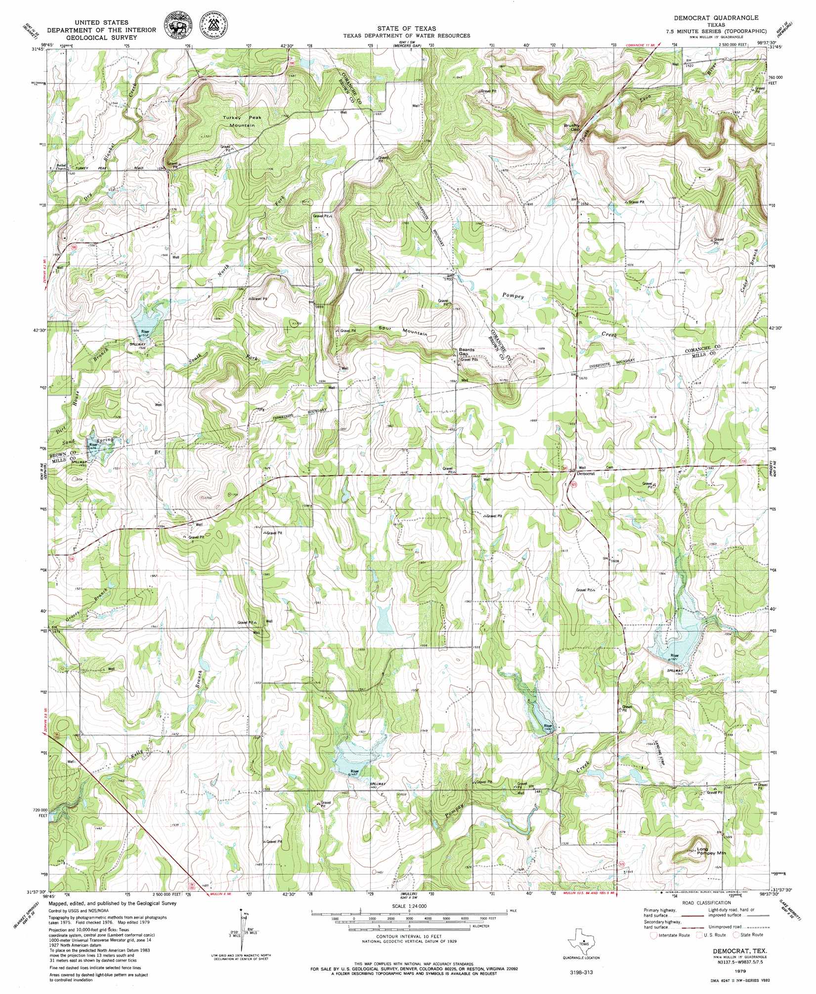
Democrat Topo Map Texas
To zoom in, hover over the map of Democrat
USGS Topo Quad 31098f6 - 1:24,000 scale
| Topo Map Name: | Democrat |
| USGS Topo Quad ID: | 31098f6 |
| Print Size: | ca. 21 1/4" wide x 27" high |
| Southeast Coordinates: | 31.625° N latitude / 98.625° W longitude |
| Map Center Coordinates: | 31.6875° N latitude / 98.6875° W longitude |
| U.S. State: | TX |
| Filename: | o31098f6.jpg |
| Download Map JPG Image: | Democrat topo map 1:24,000 scale |
| Map Type: | Topographic |
| Topo Series: | 7.5´ |
| Map Scale: | 1:24,000 |
| Source of Map Images: | United States Geological Survey (USGS) |
| Alternate Map Versions: |
Democrat TX 2010 Download PDF Buy paper map Democrat TX 2013 Download PDF Buy paper map Democrat TX 2016 Download PDF Buy paper map |
1:24,000 Topo Quads surrounding Democrat
May |
Star Mountain |
Sidney |
Comanche |
Proctor |
Owens |
Blanket |
Mercers Gap |
Newburg |
Gustine |
Brownwood |
Zephyr |
Democrat |
Priddy |
Indian Gap |
Indian Creek |
Blanket Springs |
Mullin |
Lake Merritt |
Caradan |
Bowser |
Regency |
Big Valley North |
Goldthwaite |
Center City |
> Back to 31098e1 at 1:100,000 scale
> Back to 31098a1 at 1:250,000 scale
> Back to U.S. Topo Maps home
Democrat topo map: Gazetteer
Democrat: Dams
Aldridge Lake Dam elevation 459m 1505′Lethco Lake Dam elevation 453m 1486′
Meyer Lake Dam elevation 470m 1541′
Soil Conservation Service Site 15 Dam elevation 457m 1499′
Soil Conservation Service Site 16 Dam elevation 447m 1466′
Soil Conservation Service Site 17a-1 Dam elevation 464m 1522′
Soil Conservation Service Site 18 Dam elevation 453m 1486′
Soil Conservation Service Site 19 Dam elevation 443m 1453′
Democrat: Gaps
Beards Gap elevation 527m 1729′Brushy Gap elevation 484m 1587′
Democrat: Populated Places
Democrat elevation 497m 1630′Democrat: Reservoirs
Aldridge Lake elevation 459m 1505′Blanket Creek Watershed Number 15 elevation 461m 1512′
Blanket Creek Watershed Number 16 elevation 450m 1476′
Blanket Creek Watershed Reservoir Number Eighteen elevation 457m 1499′
Blanket Creek Watershed Reservoir Number Nineteen elevation 444m 1456′
Blanket Creek Watershed Reservoir Number Seventeen elevation 464m 1522′
Lethco Lake elevation 453m 1486′
Meyer Lake elevation 470m 1541′
Soil Conservation Service Site 15 Reservoir elevation 457m 1499′
Soil Conservation Service Site 16 Reservoir elevation 447m 1466′
Soil Conservation Service Site 17a-1 Reservoir elevation 464m 1522′
Soil Conservation Service Site 18 Reservoir elevation 453m 1486′
Soil Conservation Service Site 19 Reservoir elevation 443m 1453′
Democrat: Summits
Long Pompey Mountain elevation 537m 1761′Spur Mountain elevation 549m 1801′
Turkey Peak Mountain elevation 522m 1712′
Democrat digital topo map on disk
Buy this Democrat topo map showing relief, roads, GPS coordinates and other geographical features, as a high-resolution digital map file on DVD: