Zephyr Topo Map Texas
To zoom in, hover over the map of Zephyr
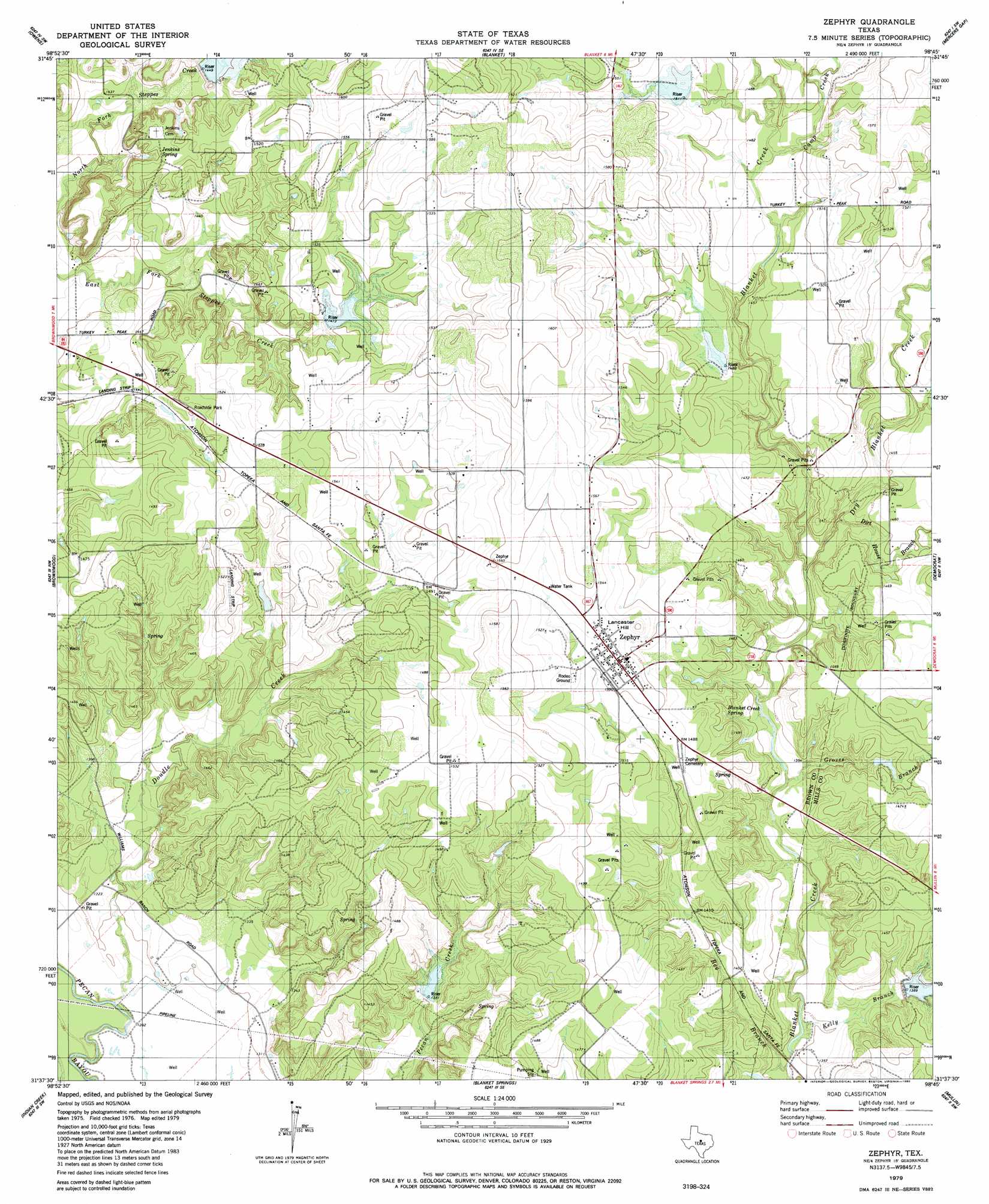
USGS Topo Quad 31098f7 - 1:24,000 scale
| Topo Map Name: | Zephyr |
| USGS Topo Quad ID: | 31098f7 |
| Print Size: | ca. 21 1/4" wide x 27" high |
| Southeast Coordinates: | 31.625° N latitude / 98.75° W longitude |
| Map Center Coordinates: | 31.6875° N latitude / 98.8125° W longitude |
| U.S. State: | TX |
| Filename: | o31098f7.jpg |
| Download Map JPG Image: | Zephyr topo map 1:24,000 scale |
| Map Type: | Topographic |
| Topo Series: | 7.5´ |
| Map Scale: | 1:24,000 |
| Source of Map Images: | United States Geological Survey (USGS) |
| Alternate Map Versions: |
Zephyr TX 1979, updated 1980 Download PDF Buy paper map Zephyr TX 2010 Download PDF Buy paper map Zephyr TX 2013 Download PDF Buy paper map Zephyr TX 2016 Download PDF Buy paper map |
1:24,000 Topo Quads surrounding Zephyr
Byrds |
May |
Star Mountain |
Sidney |
Comanche |
Lake Brownwood |
Owens |
Blanket |
Mercers Gap |
Newburg |
Bangs East |
Brownwood |
Zephyr |
Democrat |
Priddy |
Brookesmith |
Indian Creek |
Blanket Springs |
Mullin |
Lake Merritt |
Elm Grove |
Bowser |
Regency |
Big Valley North |
Goldthwaite |
> Back to 31098e1 at 1:100,000 scale
> Back to 31098a1 at 1:250,000 scale
> Back to U.S. Topo Maps home
Zephyr topo map: Gazetteer
Zephyr: Dams
Ashton Lake Dam elevation 411m 1348′Clark Lake Dam elevation 436m 1430′
Soil Conservation Service Site 20 Dam elevation 420m 1377′
Soil Conservation Service Site 21 Dam elevation 449m 1473′
Soil Conservation Service Site 22 Dam elevation 408m 1338′
Soil Conservation Service Site 26a-1 Dam elevation 410m 1345′
Soil Conservation Service Site 8 Dam elevation 463m 1519′
Soil Conservation Service Site 9 Dam elevation 450m 1476′
Taylor Dam elevation 437m 1433′
Zephyr: Populated Places
Zephyr elevation 463m 1519′Zephyr: Reservoirs
Ashton Lake elevation 411m 1348′Blanket Creek Watershed Number 8 elevation 461m 1512′
Blanket Creek Watershed Number 9 elevation 448m 1469′
Blanket Creek Watershed Reservoir Number Twenty elevation 425m 1394′
Brownwood Lateral Watershed Number 20 elevation 442m 1450′
Brownwood Lateral Watershed Number 21 elevation 449m 1473′
Brownwood Lateral Watershed Number 22 elevation 442m 1450′
Clark Lake elevation 436m 1430′
Soil Conservation Service Site 20 Reservoir elevation 420m 1377′
Soil Conservation Service Site 21 Reservoir elevation 449m 1473′
Soil Conservation Service Site 22 Reservoir elevation 408m 1338′
Soil Conservation Service Site 26a-1 Reservoir elevation 410m 1345′
Soil Conservation Service Site 8 Reservoir elevation 463m 1519′
Soil Conservation Service Site 9 Reservoir elevation 450m 1476′
Taylor Reservoir elevation 437m 1433′
Zephyr: Springs
Blanket Creek Spring elevation 435m 1427′Jenkings Spring elevation 447m 1466′
Zephyr: Streams
Bee Branch elevation 405m 1328′Camp Creek elevation 448m 1469′
Dirt House Branch elevation 440m 1443′
Double Creek elevation 387m 1269′
Dry Blanket Creek elevation 427m 1400′
Groves Branch elevation 416m 1364′
Kelly Branch elevation 408m 1338′
Sand Spring Branch elevation 427m 1400′
Zephyr: Summits
Lancaster Hill elevation 473m 1551′Zephyr digital topo map on disk
Buy this Zephyr topo map showing relief, roads, GPS coordinates and other geographical features, as a high-resolution digital map file on DVD: