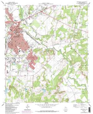
Brownwood Topo Map Texas
To zoom in, hover over the map of Brownwood
USGS Topo Quad 31098f8 - 1:24,000 scale
| Topo Map Name: | Brownwood |
| USGS Topo Quad ID: | 31098f8 |
| Print Size: | ca. 21 1/4" wide x 27" high |
| Southeast Coordinates: | 31.625° N latitude / 98.875° W longitude |
| Map Center Coordinates: | 31.6875° N latitude / 98.9375° W longitude |
| U.S. State: | TX |
| Filename: | o31098f8.jpg |
| Download Map JPG Image: | Brownwood topo map 1:24,000 scale |
| Map Type: | Topographic |
| Topo Series: | 7.5´ |
| Map Scale: | 1:24,000 |
| Source of Map Images: | United States Geological Survey (USGS) |
| Alternate Map Versions: |
Brownwood TX 1980, updated 1980 Download PDF Buy paper map Brownwood TX 1980, updated 1988 Download PDF Buy paper map Brownwood TX 1996, updated 1998 Download PDF Buy paper map Brownwood TX 1996, updated 1998 Download PDF Buy paper map Brownwood TX 2010 Download PDF Buy paper map Brownwood TX 2013 Download PDF Buy paper map Brownwood TX 2016 Download PDF Buy paper map |
1:24,000 Topo Quads surrounding Brownwood
> Back to 31098e1 at 1:100,000 scale
> Back to 31098a1 at 1:250,000 scale
> Back to U.S. Topo Maps home
Brownwood topo map: Gazetteer
Brownwood: Dams
Country Club Dam elevation 434m 1423′Municipal Reservoir Upper Dam elevation 406m 1332′
Soil Conservation Service Site 25 Dam elevation 437m 1433′
Soil Conservation Service Site 4a Dam elevation 442m 1450′
Soil Conservation Service Site 4b Dam elevation 440m 1443′
Brownwood: Parks
36th Division Memorial Park elevation 431m 1414′Adair Spring Park elevation 399m 1309′
Allcorn Park elevation 423m 1387′
Brownwood City Park elevation 427m 1400′
Bunnin Park elevation 416m 1364′
Camp Bowie Memorial Air Park elevation 420m 1377′
Camp Bowie Park elevation 422m 1384′
Clark Park elevation 411m 1348′
Clark Park elevation 411m 1348′
Coggin Park elevation 410m 1345′
Coggin Park elevation 410m 1345′
Cordell Park elevation 406m 1332′
Cordell Park elevation 406m 1332′
Early City Park elevation 426m 1397′
Gordon Wood Stadium elevation 420m 1377′
Kiwanis Park elevation 406m 1332′
Kiwanis Park elevation 406m 1332′
Longhron Stadium elevation 429m 1407′
Mayes Park elevation 409m 1341′
Mayes Park elevation 409m 1341′
McDonald Field elevation 429m 1407′
Red Stone Park elevation 433m 1420′
Riverside Park elevation 406m 1332′
Sharp Park elevation 403m 1322′
Sportsman Park elevation 422m 1384′
Stonegate Park elevation 413m 1354′
Thomason Park elevation 428m 1404′
Vincent Street Park elevation 409m 1341′
Wiggins Park elevation 411m 1348′
Wiggins Park elevation 411m 1348′
Brownwood: Populated Places
Brownwood elevation 416m 1364′Early elevation 431m 1414′
Ricker (historical) elevation 402m 1318′
Tenmile Crossing elevation 386m 1266′
Woodland Heights elevation 425m 1394′
Brownwood: Reservoirs
Brownwood Lateral Watershed Number 23 elevation 435m 1427′Brownwood Lateral Watershed Number 4A elevation 443m 1453′
Brownwood Lateral Watershed Number 4-B elevation 445m 1459′
Camp Bowie Reservoir elevation 421m 1381′
Country Club Lake elevation 434m 1423′
Municipal Reservoir elevation 406m 1332′
Soil Conservation Service Site 25 Reservoir elevation 437m 1433′
Soil Conservation Service Site 4a Reservoir elevation 442m 1450′
Soil Conservation Service Site 4b Reservoir elevation 440m 1443′
Brownwood: Streams
Adams Branch elevation 395m 1295′Adams Branch elevation 399m 1309′
Delaware Creek elevation 396m 1299′
East Fork Steppes Creek elevation 411m 1348′
Lewis Creek elevation 391m 1282′
North Fork Steppes Creek elevation 414m 1358′
South Willis Creek elevation 405m 1328′
Steppes Creek elevation 392m 1286′
Williams Creek elevation 405m 1328′
Willis Creek elevation 395m 1295′
Brownwood digital topo map on disk
Buy this Brownwood topo map showing relief, roads, GPS coordinates and other geographical features, as a high-resolution digital map file on DVD:


