Edna Hill Topo Map Texas
To zoom in, hover over the map of Edna Hill
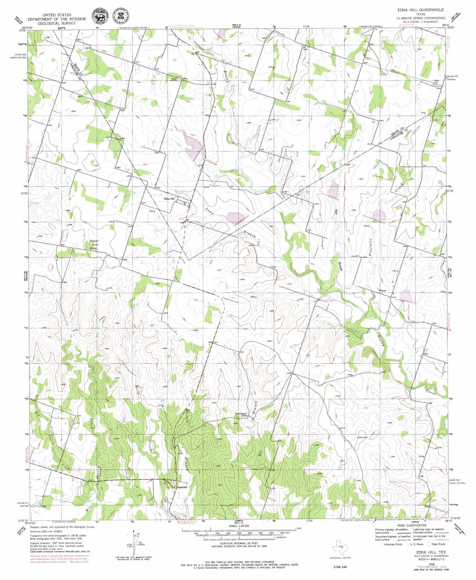
USGS Topo Quad 31098h3 - 1:24,000 scale
| Topo Map Name: | Edna Hill |
| USGS Topo Quad ID: | 31098h3 |
| Print Size: | ca. 21 1/4" wide x 27" high |
| Southeast Coordinates: | 31.875° N latitude / 98.25° W longitude |
| Map Center Coordinates: | 31.9375° N latitude / 98.3125° W longitude |
| U.S. State: | TX |
| Filename: | o31098h3.jpg |
| Download Map JPG Image: | Edna Hill topo map 1:24,000 scale |
| Map Type: | Topographic |
| Topo Series: | 7.5´ |
| Map Scale: | 1:24,000 |
| Source of Map Images: | United States Geological Survey (USGS) |
| Alternate Map Versions: |
Edna Hill TX 1956, updated 1957 Download PDF Buy paper map Edna Hill TX 1956, updated 1979 Download PDF Buy paper map Edna Hill TX 2010 Download PDF Buy paper map Edna Hill TX 2013 Download PDF Buy paper map Edna Hill TX 2016 Download PDF Buy paper map |
1:24,000 Topo Quads surrounding Edna Hill
Rucker |
Lingleville |
Bunyan |
Stephenville |
Johnsville |
De Leon |
Comyn |
Dublin |
Alexander |
Clairette |
Comanche |
Proctor |
Edna Hill |
Carlton |
Hico |
Newburg |
Gustine |
Lamkin |
Gentrys Mill |
Eidson Lake |
Priddy |
Indian Gap |
Pottsville |
Hamilton West |
Hamilton East |
> Back to 31098e1 at 1:100,000 scale
> Back to 31098a1 at 1:250,000 scale
> Back to U.S. Topo Maps home
Edna Hill topo map: Gazetteer
Edna Hill: Dams
Soil Conservation Service Site 18 Dam elevation 409m 1341′Soil Conservation Service Site 19 Dam elevation 389m 1276′
Soil Conservation Service Site 20 Dam elevation 381m 1250′
Soil Conservation Service Site 21 Dam elevation 390m 1279′
Soil Conservation Service Site 22 Dam elevation 382m 1253′
Soil Conservation Service Site 23 Dam elevation 366m 1200′
Edna Hill: Populated Places
Edna Hill elevation 405m 1328′Hazeldell elevation 346m 1135′
Wilson elevation 376m 1233′
Edna Hill: Reservoirs
Soil Conservation Service Site 18 Reservoir elevation 409m 1341′Soil Conservation Service Site 19 Reservoir elevation 389m 1276′
Soil Conservation Service Site 20 Reservoir elevation 381m 1250′
Soil Conservation Service Site 21 Reservoir elevation 390m 1279′
Soil Conservation Service Site 22 Reservoir elevation 382m 1253′
Soil Conservation Service Site 23 Reservoir elevation 366m 1200′
Edna Hill: Streams
Dry Joplin Creek elevation 333m 1092′Fourmile Creek elevation 351m 1151′
Long Branch elevation 367m 1204′
Salt Branch elevation 360m 1181′
Sawyer Branch elevation 397m 1302′
Edna Hill: Summits
Sand Mountain elevation 441m 1446′Edna Hill digital topo map on disk
Buy this Edna Hill topo map showing relief, roads, GPS coordinates and other geographical features, as a high-resolution digital map file on DVD: