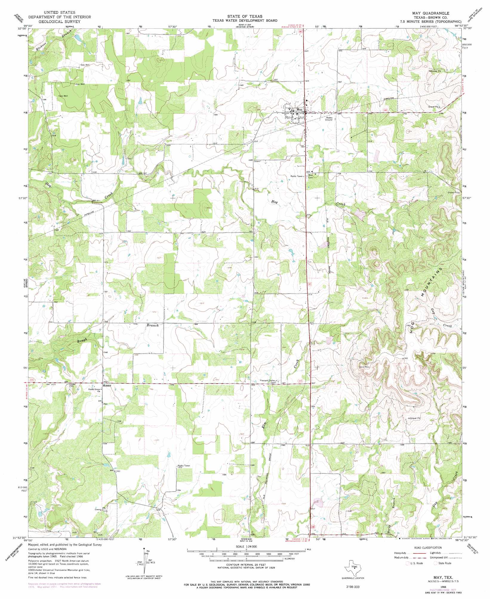
May Topo Map Texas
To zoom in, hover over the map of May
USGS Topo Quad 31098h8 - 1:24,000 scale
| Topo Map Name: | May |
| USGS Topo Quad ID: | 31098h8 |
| Print Size: | ca. 21 1/4" wide x 27" high |
| Southeast Coordinates: | 31.875° N latitude / 98.875° W longitude |
| Map Center Coordinates: | 31.9375° N latitude / 98.9375° W longitude |
| U.S. State: | TX |
| Filename: | o31098h8.jpg |
| Download Map JPG Image: | May topo map 1:24,000 scale |
| Map Type: | Topographic |
| Topo Series: | 7.5´ |
| Map Scale: | 1:24,000 |
| Source of Map Images: | United States Geological Survey (USGS) |
| Alternate Map Versions: |
May TX 1966, updated 1968 Download PDF Buy paper map May TX 1966, updated 1978 Download PDF Buy paper map May TX 2010 Download PDF Buy paper map May TX 2012 Download PDF Buy paper map May TX 2016 Download PDF Buy paper map |
1:24,000 Topo Quads surrounding May
Cross Plains North |
Sabanno |
Union Center |
Hunting Shirt Creek |
Gorman |
Cross Cut |
Pioneer |
Rising Star |
Sipe Springs |
Duster |
Burkett |
Byrds |
May |
Star Mountain |
Sidney |
Thrifty |
Lake Brownwood |
Owens |
Blanket |
Mercers Gap |
Bangs West |
Bangs East |
Brownwood |
Zephyr |
Democrat |
> Back to 31098e1 at 1:100,000 scale
> Back to 31098a1 at 1:250,000 scale
> Back to U.S. Topo Maps home
May topo map: Gazetteer
May: Dams
Soil Conservation Service Site 10a Dam elevation 473m 1551′Soil Conservation Service Site 31 Dam elevation 523m 1715′
Soil Conservation Service Site 32 Dam elevation 512m 1679′
Soil Conservation Service Site 33 Dam elevation 508m 1666′
Soil Conservation Service Site 6 Dam elevation 507m 1663′
May: Populated Places
Holder elevation 470m 1541′May elevation 508m 1666′
May: Reservoirs
Soil Conservation Service Site 10a Reservoir elevation 473m 1551′Soil Conservation Service Site 31 Reservoir elevation 523m 1715′
Soil Conservation Service Site 32 Reservoir elevation 512m 1679′
Soil Conservation Service Site 33 Reservoir elevation 508m 1666′
Soil Conservation Service Site 6 Reservoir elevation 507m 1663′
May digital topo map on disk
Buy this May topo map showing relief, roads, GPS coordinates and other geographical features, as a high-resolution digital map file on DVD: