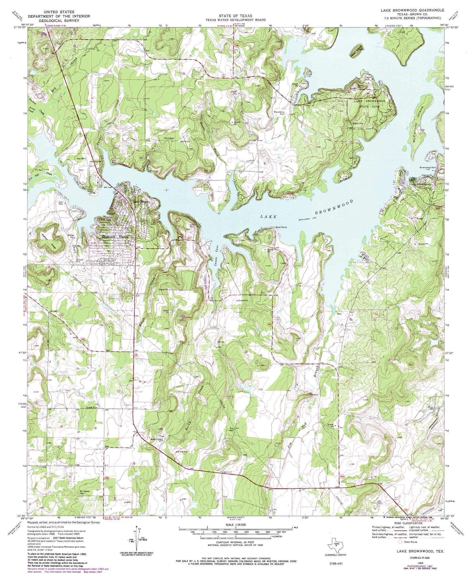
Lake Brownwood Topo Map Texas
To zoom in, hover over the map of Lake Brownwood
USGS Topo Quad 31099g1 - 1:24,000 scale
| Topo Map Name: | Lake Brownwood |
| USGS Topo Quad ID: | 31099g1 |
| Print Size: | ca. 21 1/4" wide x 27" high |
| Southeast Coordinates: | 31.75° N latitude / 99° W longitude |
| Map Center Coordinates: | 31.8125° N latitude / 99.0625° W longitude |
| U.S. State: | TX |
| Filename: | o31099g1.jpg |
| Download Map JPG Image: | Lake Brownwood topo map 1:24,000 scale |
| Map Type: | Topographic |
| Topo Series: | 7.5´ |
| Map Scale: | 1:24,000 |
| Source of Map Images: | United States Geological Survey (USGS) |
| Alternate Map Versions: |
Lake Brownwood TX 1969, updated 1972 Download PDF Buy paper map Lake Brownwood TX 1969, updated 1978 Download PDF Buy paper map Lake Brownwood TX 1969, updated 1988 Download PDF Buy paper map Lake Brownwood TX 2010 Download PDF Buy paper map Lake Brownwood TX 2013 Download PDF Buy paper map Lake Brownwood TX 2016 Download PDF Buy paper map |
1:24,000 Topo Quads surrounding Lake Brownwood
Webbville |
Cross Cut |
Pioneer |
Rising Star |
Sipe Springs |
Coleman Ne |
Burkett |
Byrds |
May |
Star Mountain |
Lake San Tana |
Thrifty |
Lake Brownwood |
Owens |
Blanket |
Santa Anna |
Bangs West |
Bangs East |
Brownwood |
Zephyr |
Speck Mountain |
Trickham |
Brookesmith |
Indian Creek |
Blanket Springs |
> Back to 31099e1 at 1:100,000 scale
> Back to 31098a1 at 1:250,000 scale
> Back to U.S. Topo Maps home
Lake Brownwood topo map: Gazetteer
Lake Brownwood: Bays
Cason Cove elevation 434m 1423′Lake Brownwood: Dams
Brownwood Dam elevation 437m 1433′Soil Conservation Service Site 8 Dam elevation 427m 1400′
Lake Brownwood: Islands
Goat Island elevation 440m 1443′McCartney Island elevation 441m 1446′
Lake Brownwood: Parks
Lake Brownwood State Park elevation 448m 1469′Lake Brownwood: Populated Places
Lake Brownwood elevation 440m 1443′Lake Shore elevation 457m 1499′
Shamrock Shores elevation 453m 1486′
Lake Brownwood: Reservoirs
Brownwood Lake elevation 435m 1427′Brownwood Reservoir elevation 412m 1351′
Lake Brownwood elevation 438m 1437′
Soil Conservation Service Site 8 Reservoir elevation 427m 1400′
Lake Brownwood: Streams
Briar Creek elevation 436m 1430′Dry Creek elevation 434m 1423′
Jim Ned Branch elevation 435m 1427′
Jim Ned Creek elevation 434m 1423′
Keesee Creek elevation 437m 1433′
Panther Creek elevation 436m 1430′
Rocky Creek elevation 434m 1423′
Rough Creek elevation 436m 1430′
Short Creek elevation 437m 1433′
Turner Creek elevation 434m 1423′
Lake Brownwood: Trails
Lake Brownwood State Park Trail elevation 445m 1459′Lake Brownwood digital topo map on disk
Buy this Lake Brownwood topo map showing relief, roads, GPS coordinates and other geographical features, as a high-resolution digital map file on DVD: