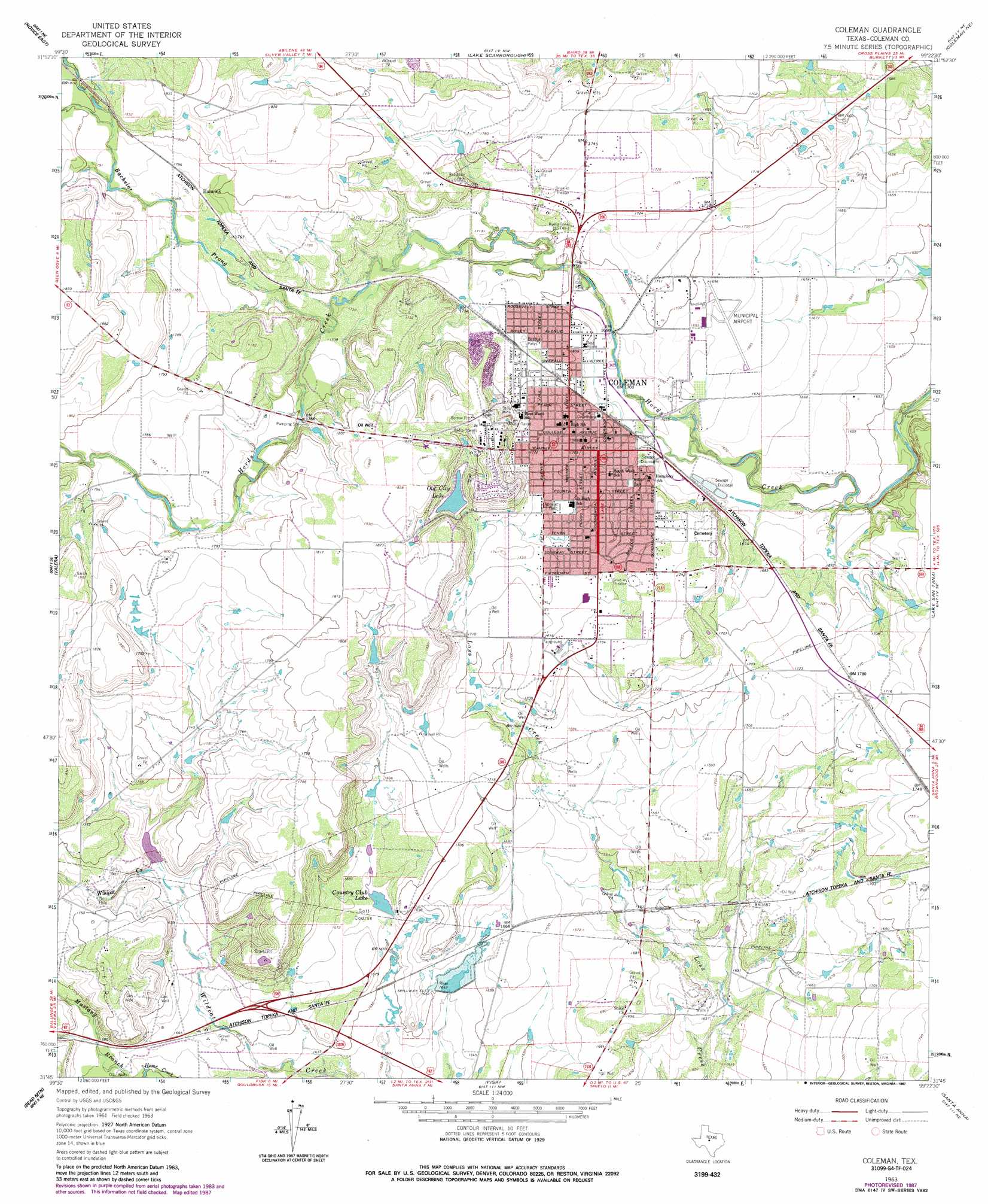
Coleman Topo Map Texas
To zoom in, hover over the map of Coleman
USGS Topo Quad 31099g4 - 1:24,000 scale
| Topo Map Name: | Coleman |
| USGS Topo Quad ID: | 31099g4 |
| Print Size: | ca. 21 1/4" wide x 27" high |
| Southeast Coordinates: | 31.75° N latitude / 99.375° W longitude |
| Map Center Coordinates: | 31.8125° N latitude / 99.4375° W longitude |
| U.S. State: | TX |
| Filename: | o31099g4.jpg |
| Download Map JPG Image: | Coleman topo map 1:24,000 scale |
| Map Type: | Topographic |
| Topo Series: | 7.5´ |
| Map Scale: | 1:24,000 |
| Source of Map Images: | United States Geological Survey (USGS) |
| Alternate Map Versions: |
Coleman TX 1963, updated 1964 Download PDF Buy paper map Coleman TX 1963, updated 1987 Download PDF Buy paper map Coleman TX 2010 Download PDF Buy paper map Coleman TX 2013 Download PDF Buy paper map Coleman TX 2016 Download PDF Buy paper map |
1:24,000 Topo Quads surrounding Coleman
Goldsboro |
Mcewen Draw |
Crooked Creek |
Webbville |
Cross Cut |
Novice West |
Novice East |
Lake Scarborough |
Coleman Ne |
Burkett |
Talpa |
Valera |
Coleman |
Lake San Tana |
Thrifty |
Little Grape Creek |
Bead Mountain |
Fisk |
Santa Anna |
Bangs West |
Leaday |
Voss |
Gouldbusk |
Speck Mountain |
Trickham |
> Back to 31099e1 at 1:100,000 scale
> Back to 31098a1 at 1:250,000 scale
> Back to U.S. Topo Maps home
Coleman topo map: Gazetteer
Coleman: Airports
Coleman Municipal Airport elevation 514m 1686′Coleman: Dams
Coleman Country Club Dam elevation 508m 1666′Hunter Lake Dam elevation 533m 1748′
Soil Conservation Service Site 38a Dam elevation 533m 1748′
Soil Conservation Service Site 5 Dam elevation 525m 1722′
Soil Conservation Service Site 6a Dam elevation 501m 1643′
Taylor Brothers Dam elevation 543m 1781′
Coleman: Parks
Coleman City Park elevation 516m 1692′Mills Park elevation 515m 1689′
Coleman: Populated Places
Coleman elevation 519m 1702′Hamrick elevation 542m 1778′
Coleman: Reservoirs
Country Club Lake elevation 508m 1666′Hunter Lake elevation 533m 1748′
Old City Lake elevation 533m 1748′
Soil Conservation Service Site 38a Reservoir elevation 533m 1748′
Soil Conservation Service Site 5 Reservoir elevation 525m 1722′
Soil Conservation Service Site 6a Reservoir elevation 501m 1643′
Taylor Brothers Lake elevation 543m 1781′
Coleman: Streams
Bachelor Prong elevation 529m 1735′Coleman digital topo map on disk
Buy this Coleman topo map showing relief, roads, GPS coordinates and other geographical features, as a high-resolution digital map file on DVD: