Lake Scarborough Topo Map Texas
To zoom in, hover over the map of Lake Scarborough
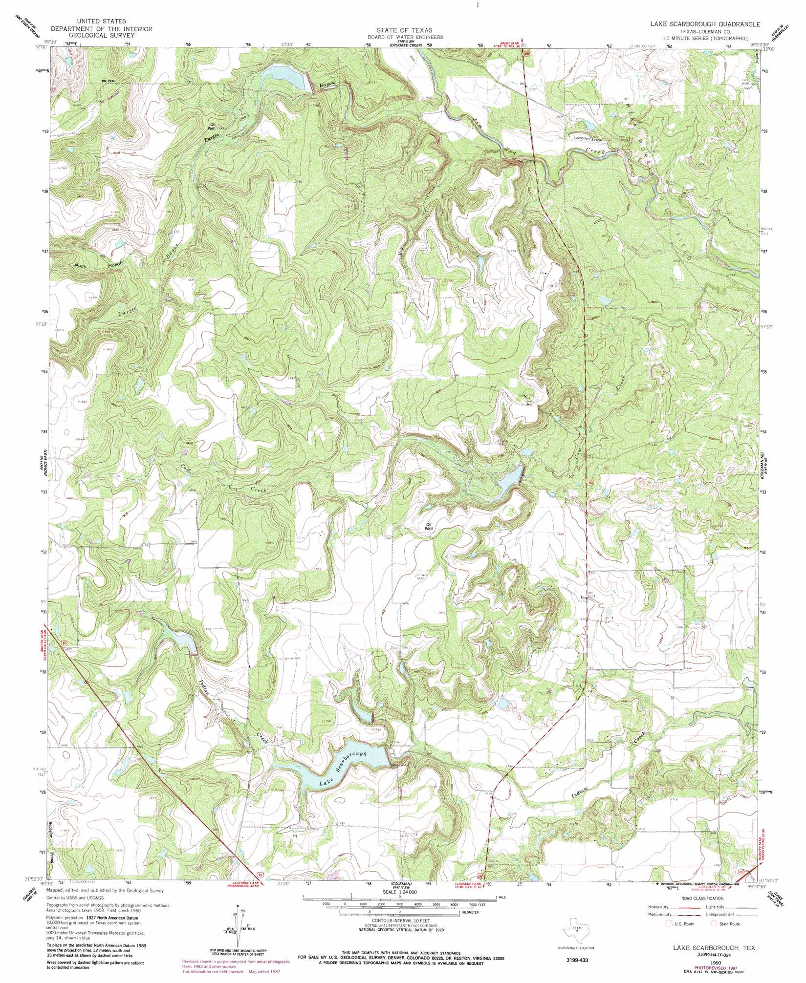
USGS Topo Quad 31099h4 - 1:24,000 scale
| Topo Map Name: | Lake Scarborough |
| USGS Topo Quad ID: | 31099h4 |
| Print Size: | ca. 21 1/4" wide x 27" high |
| Southeast Coordinates: | 31.875° N latitude / 99.375° W longitude |
| Map Center Coordinates: | 31.9375° N latitude / 99.4375° W longitude |
| U.S. State: | TX |
| Filename: | o31099h4.jpg |
| Download Map JPG Image: | Lake Scarborough topo map 1:24,000 scale |
| Map Type: | Topographic |
| Topo Series: | 7.5´ |
| Map Scale: | 1:24,000 |
| Source of Map Images: | United States Geological Survey (USGS) |
| Alternate Map Versions: |
Lake Scarborough TX 1960, updated 1962 Download PDF Buy paper map Lake Scarborough TX 1960, updated 1988 Download PDF Buy paper map Lake Scarborough TX 2010 Download PDF Buy paper map Lake Scarborough TX 2013 Download PDF Buy paper map Lake Scarborough TX 2016 Download PDF Buy paper map |
1:24,000 Topo Quads surrounding Lake Scarborough
Lawn |
Oplin |
Rowden Nw |
Rowden |
Cross Plains North |
Goldsboro |
Mcewen Draw |
Crooked Creek |
Webbville |
Cross Cut |
Novice West |
Novice East |
Lake Scarborough |
Coleman Ne |
Burkett |
Talpa |
Valera |
Coleman |
Lake San Tana |
Thrifty |
Little Grape Creek |
Bead Mountain |
Fisk |
Santa Anna |
Bangs West |
> Back to 31099e1 at 1:100,000 scale
> Back to 31098a1 at 1:250,000 scale
> Back to U.S. Topo Maps home
Lake Scarborough topo map: Gazetteer
Lake Scarborough: Dams
Lake Scarborough Dam elevation 524m 1719′Soil Conservation Service Site 23 Dam elevation 523m 1715′
Soil Conservation Service Site 24 Dam elevation 517m 1696′
Soil Conservation Service Site 25a Dam elevation 551m 1807′
Soil Conservation Service Site 25b Dam elevation 529m 1735′
Lake Scarborough: Oilfields
Amzak-Morris Oil Field elevation 511m 1676′Lake Scarborough: Reservoirs
Lake Scarborough elevation 517m 1696′Soil Conservation Service Site 23 Reservoir elevation 523m 1715′
Soil Conservation Service Site 24 Reservoir elevation 517m 1696′
Soil Conservation Service Site 25a Reservoir elevation 551m 1807′
Soil Conservation Service Site 25b Reservoir elevation 529m 1735′
Lake Scarborough: Streams
Hog Creek elevation 491m 1610′Turtle Bayou elevation 491m 1610′
Lake Scarborough: Valleys
Buck Hollow elevation 537m 1761′Lake Scarborough digital topo map on disk
Buy this Lake Scarborough topo map showing relief, roads, GPS coordinates and other geographical features, as a high-resolution digital map file on DVD: