Murph Draw Topo Map Texas
To zoom in, hover over the map of Murph Draw
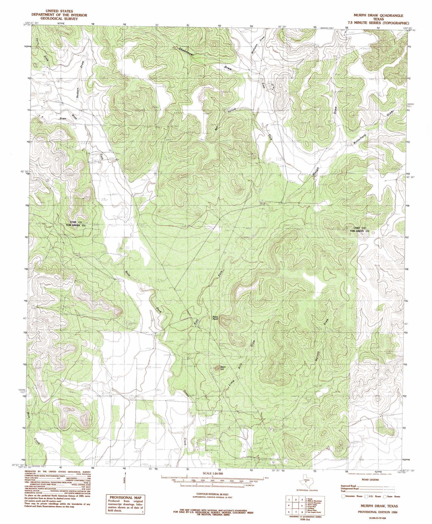
USGS Topo Quad 31100f5 - 1:24,000 scale
| Topo Map Name: | Murph Draw |
| USGS Topo Quad ID: | 31100f5 |
| Print Size: | ca. 21 1/4" wide x 27" high |
| Southeast Coordinates: | 31.625° N latitude / 100.5° W longitude |
| Map Center Coordinates: | 31.6875° N latitude / 100.5625° W longitude |
| U.S. State: | TX |
| Filename: | o31100f5.jpg |
| Download Map JPG Image: | Murph Draw topo map 1:24,000 scale |
| Map Type: | Topographic |
| Topo Series: | 7.5´ |
| Map Scale: | 1:24,000 |
| Source of Map Images: | United States Geological Survey (USGS) |
| Alternate Map Versions: |
Murph Draw TX 1984, updated 1984 Download PDF Buy paper map Murph Draw TX 2010 Download PDF Buy paper map Murph Draw TX 2012 Download PDF Buy paper map Murph Draw TX 2016 Download PDF Buy paper map |
1:24,000 Topo Quads surrounding Murph Draw
Crawford Slide |
Green Mountain |
Edith |
Robert Lee |
Bronte |
Broome |
Divide |
Millican Mountains |
Cement Mountain |
Shawville |
Dog Creek Ne |
Water Valley |
Murph Draw |
Pecan Mott |
Tennyson |
Dog Creek |
Carlsbad |
Mount Nebo |
San Angelo North |
Harriet |
Arden |
Knickerbocker Nw |
Twin Buttes |
San Angelo South |
Veribest |
> Back to 31100e1 at 1:100,000 scale
> Back to 31100a1 at 1:250,000 scale
> Back to U.S. Topo Maps home
Murph Draw topo map: Gazetteer
Murph Draw: Arroyos
Bee Hollow elevation 730m 2395′Butterfield Draw elevation 678m 2224′
Hudson Draw elevation 676m 2217′
Lime Kiln Draw elevation 724m 2375′
Murph Draw elevation 735m 2411′
Narvell Draw elevation 718m 2355′
Shoonover Draw elevation 676m 2217′
Murph Draw: Streams
East Fork Grape Creek elevation 628m 2060′West Fork Grape Creek elevation 628m 2060′
Murph Draw: Summits
Bean Hill elevation 698m 2290′Ruby Point elevation 724m 2375′
Murph Draw: Valleys
Williams Draw elevation 686m 2250′Murph Draw digital topo map on disk
Buy this Murph Draw topo map showing relief, roads, GPS coordinates and other geographical features, as a high-resolution digital map file on DVD: