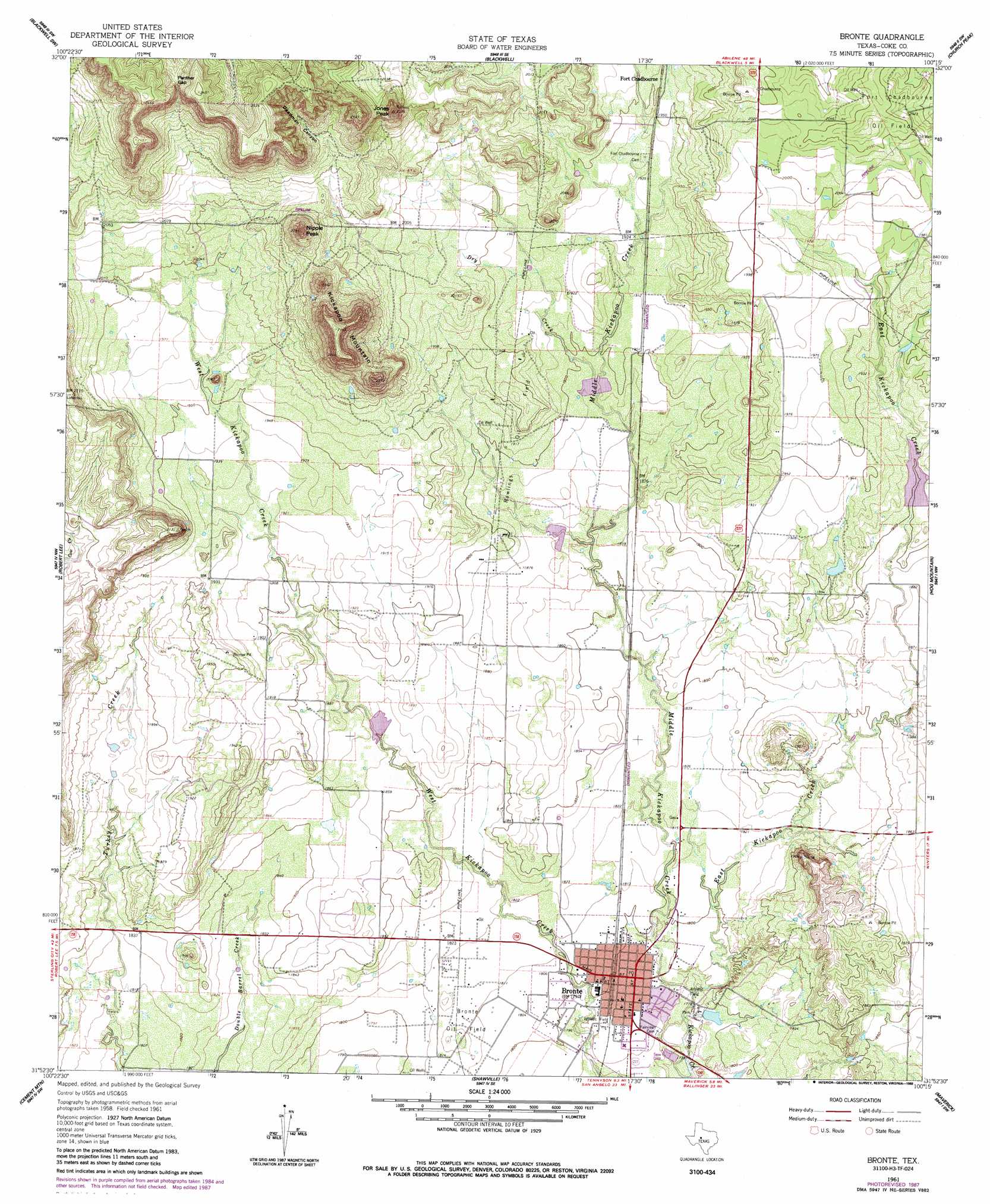
Bronte Topo Map Texas
To zoom in, hover over the map of Bronte
USGS Topo Quad 31100h3 - 1:24,000 scale
| Topo Map Name: | Bronte |
| USGS Topo Quad ID: | 31100h3 |
| Print Size: | ca. 21 1/4" wide x 27" high |
| Southeast Coordinates: | 31.875° N latitude / 100.25° W longitude |
| Map Center Coordinates: | 31.9375° N latitude / 100.3125° W longitude |
| U.S. State: | TX |
| Filename: | o31100h3.jpg |
| Download Map JPG Image: | Bronte topo map 1:24,000 scale |
| Map Type: | Topographic |
| Topo Series: | 7.5´ |
| Map Scale: | 1:24,000 |
| Source of Map Images: | United States Geological Survey (USGS) |
| Alternate Map Versions: |
Bronte TX 1961, updated 1962 Download PDF Buy paper map Bronte TX 1961, updated 1988 Download PDF Buy paper map Bronte TX 2010 Download PDF Buy paper map Bronte TX 2013 Download PDF Buy paper map Bronte TX 2016 Download PDF Buy paper map |
1:24,000 Topo Quads surrounding Bronte
Dew Drop Creek |
Maryneal |
Blackwell Ne |
Hylton |
Shep |
Sanco |
Blackwell Sw |
Blackwell |
Church Peak |
Wingate |
Edith |
Robert Lee |
Bronte |
Hog Mountain |
Wilmeth |
Millican Mountains |
Cement Mountain |
Shawville |
Maverick |
Herring Ranch |
Murph Draw |
Pecan Mott |
Tennyson |
Miles Nw |
Rowena |
> Back to 31100e1 at 1:100,000 scale
> Back to 31100a1 at 1:250,000 scale
> Back to U.S. Topo Maps home
Bronte topo map: Gazetteer
Bronte: Dams
Edward Rawling Lower Tank Dam elevation 571m 1873′Edward Rawling Upper Tank Dam elevation 572m 1876′
Old City Lake Dam elevation 546m 1791′
Soil Conservation Service Site 2 Dam elevation 572m 1876′
Soil Conservation Service Site 3 Dam elevation 567m 1860′
Soil Conservation Service Site 5 Dam elevation 573m 1879′
Soil Conservation Service Site 6 Dam elevation 577m 1893′
Bronte: Gaps
Panther Gap elevation 710m 2329′Bronte: Oilfields
Bronte Oil Field elevation 558m 1830′Rawlings Oil Field elevation 584m 1916′
Bronte: Populated Places
Bronte elevation 547m 1794′Bronte: Reservoirs
Edward Rawling Lower Tank elevation 571m 1873′Edward Rawling Upper Tank elevation 572m 1876′
Old City Lake elevation 546m 1791′
Soil Conservation Service Site 2 Reservoir elevation 572m 1876′
Soil Conservation Service Site 3 Reservoir elevation 567m 1860′
Soil Conservation Service Site 5 Reservoir elevation 573m 1879′
Soil Conservation Service Site 6 Reservoir elevation 577m 1893′
Bronte: Streams
Dry Creek elevation 576m 1889′East Kickapoo Creek elevation 540m 1771′
Middle Kickapoo Creek elevation 540m 1771′
Bronte: Summits
Jones Peak elevation 710m 2329′Kickapoo Mountain elevation 745m 2444′
Nipple Peak elevation 716m 2349′
Bronte: Valleys
Deadman Canyon elevation 643m 2109′Bronte digital topo map on disk
Buy this Bronte topo map showing relief, roads, GPS coordinates and other geographical features, as a high-resolution digital map file on DVD: