Monahans Topo Map Texas
To zoom in, hover over the map of Monahans
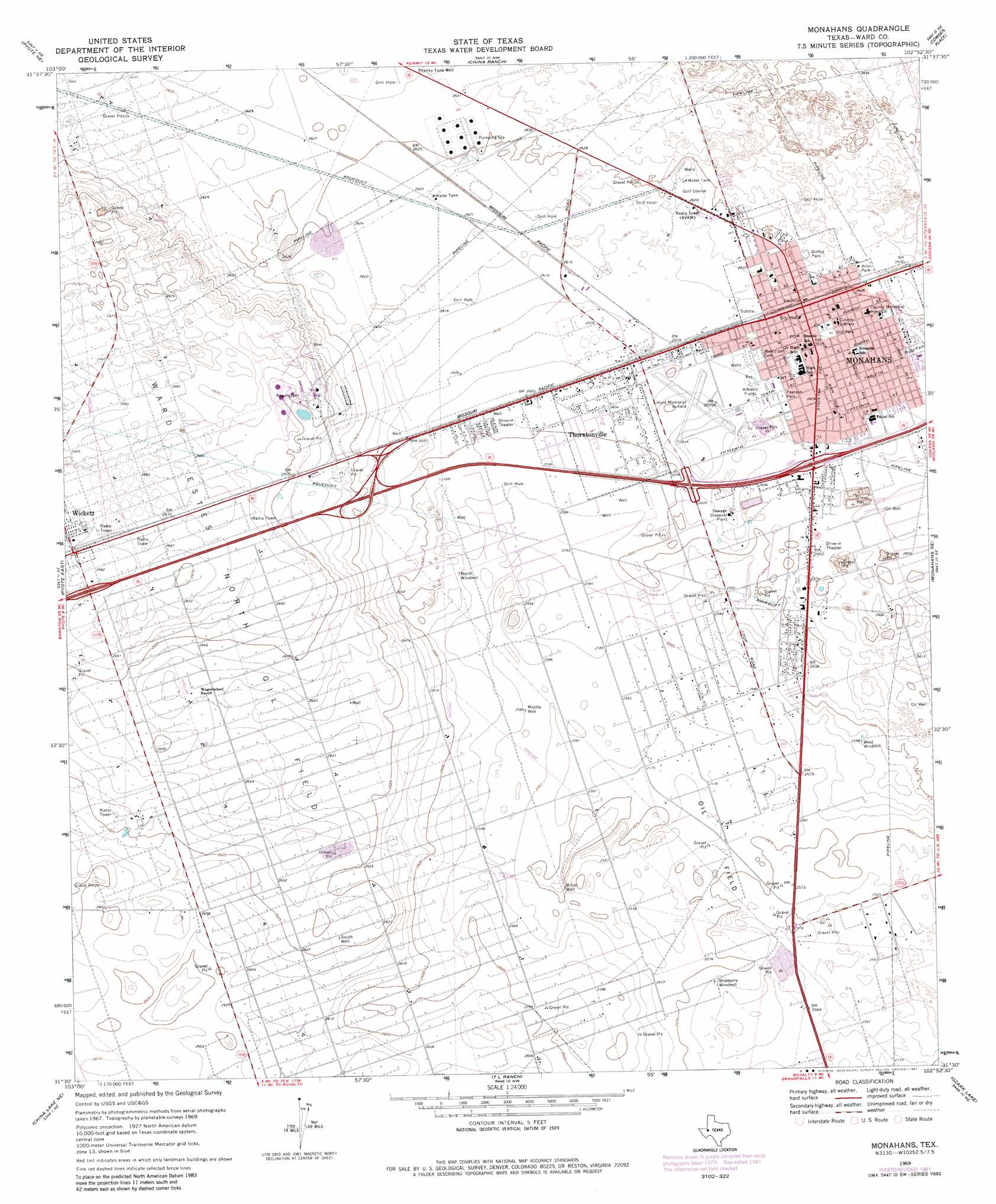
USGS Topo Quad 31102e8 - 1:24,000 scale
| Topo Map Name: | Monahans |
| USGS Topo Quad ID: | 31102e8 |
| Print Size: | ca. 21 1/4" wide x 27" high |
| Southeast Coordinates: | 31.5° N latitude / 102.875° W longitude |
| Map Center Coordinates: | 31.5625° N latitude / 102.9375° W longitude |
| U.S. State: | TX |
| Filename: | o31102e8.jpg |
| Download Map JPG Image: | Monahans topo map 1:24,000 scale |
| Map Type: | Topographic |
| Topo Series: | 7.5´ |
| Map Scale: | 1:24,000 |
| Source of Map Images: | United States Geological Survey (USGS) |
| Alternate Map Versions: |
Monahans TX 1969, updated 1971 Download PDF Buy paper map Monahans TX 1969, updated 1981 Download PDF Buy paper map Monahans TX 2010 Download PDF Buy paper map Monahans TX 2012 Download PDF Buy paper map Monahans TX 2016 Download PDF Buy paper map |
1:24,000 Topo Quads surrounding Monahans
Wink North |
Kermit |
Wheeler Ranch |
Amburgey Ranch |
Red Lakes |
Wink South |
Pyote Ne |
China Ranch |
Cowden Place |
Metz |
Pyote West |
Pyote East |
Monahans |
Monahans Se |
Penwell Sw |
China Lake |
China Lake Ne |
7 L Ranch |
Ozark Lake |
Imperial Nw |
Ligon Ranch |
Rio Pecos Ranch |
Grandfalls Sw |
Grandfalls |
Imperial |
> Back to 31102e1 at 1:100,000 scale
> Back to 31102a1 at 1:250,000 scale
> Back to U.S. Topo Maps home
Monahans topo map: Gazetteer
Monahans: Airports
Roy Hurd Memorial Airport elevation 794m 2604′Monahans: Oilfields
Ward Estes North Oil Field elevation 807m 2647′Monahans: Parks
Allen Park elevation 802m 2631′Duffey Park elevation 802m 2631′
Hill Park elevation 798m 2618′
Lobo Stadium elevation 796m 2611′
Pearson Park elevation 795m 2608′
Rudy Park elevation 799m 2621′
Monahans: Populated Places
Monahans elevation 799m 2621′Thorntonville elevation 794m 2604′
Monahans: Wells
Bitter Well elevation 786m 2578′Honky Tonk Well elevation 802m 2631′
Middle Well elevation 788m 2585′
South Well elevation 801m 2627′
Monahans digital topo map on disk
Buy this Monahans topo map showing relief, roads, GPS coordinates and other geographical features, as a high-resolution digital map file on DVD: