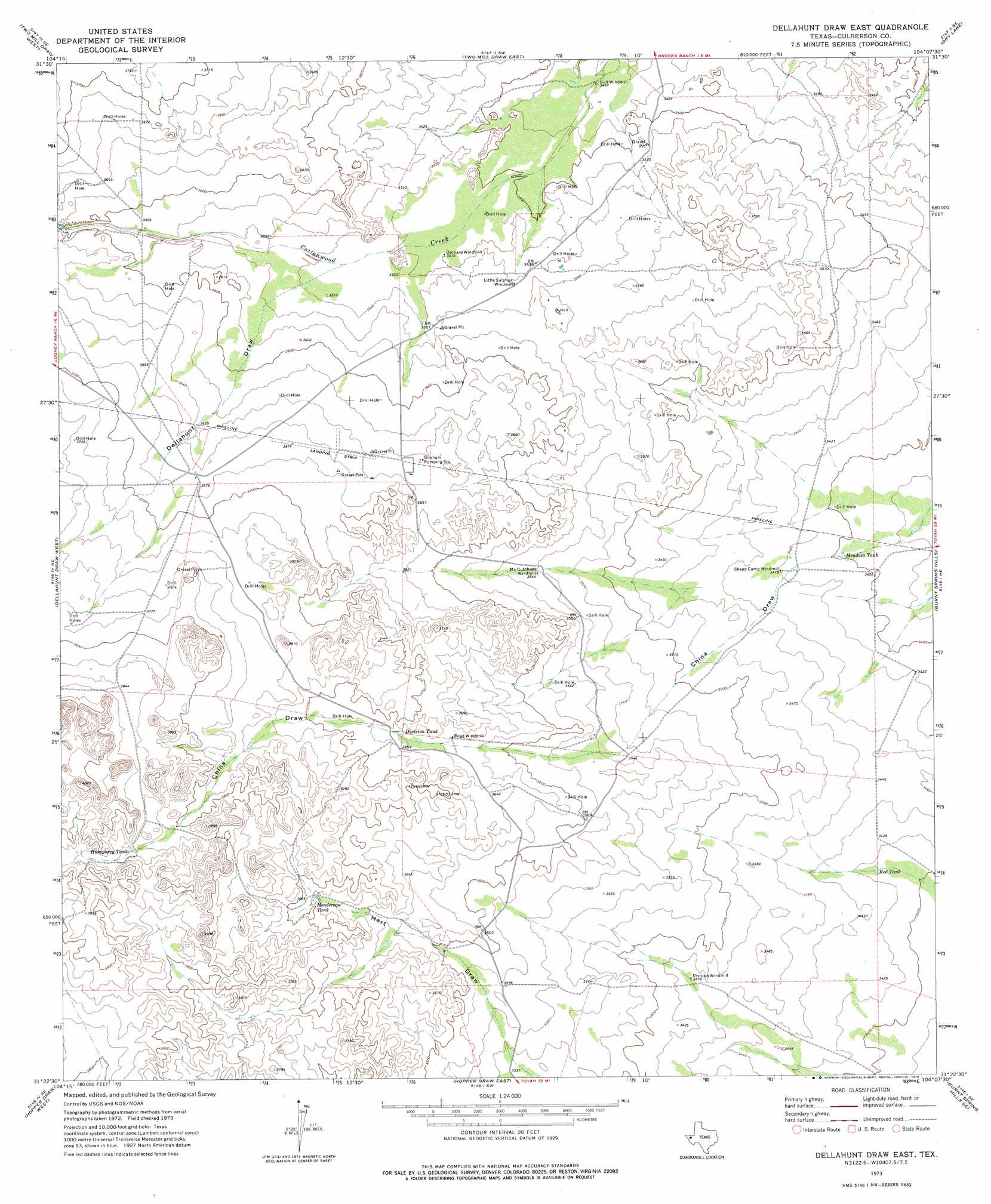
Dellahunt Draw East Topo Map Texas
To zoom in, hover over the map of Dellahunt Draw East
USGS Topo Quad 31104d2 - 1:24,000 scale
| Topo Map Name: | Dellahunt Draw East |
| USGS Topo Quad ID: | 31104d2 |
| Print Size: | ca. 21 1/4" wide x 27" high |
| Southeast Coordinates: | 31.375° N latitude / 104.125° W longitude |
| Map Center Coordinates: | 31.4375° N latitude / 104.1875° W longitude |
| U.S. State: | TX |
| Filename: | o31104d2.jpg |
| Download Map JPG Image: | Dellahunt Draw East topo map 1:24,000 scale |
| Map Type: | Topographic |
| Topo Series: | 7.5´ |
| Map Scale: | 1:24,000 |
| Source of Map Images: | United States Geological Survey (USGS) |
| Alternate Map Versions: |
Dellahunt Draw East TX 1973, updated 1976 Download PDF Buy paper map Dellahunt Draw East TX 2010 Download PDF Buy paper map Dellahunt Draw East TX 2012 Download PDF Buy paper map Dellahunt Draw East TX 2016 Download PDF Buy paper map |
1:24,000 Topo Quads surrounding Dellahunt Draw East
Seven L Peak |
Seven L Peak Ne |
Rustler Hills |
Derrick Draw |
Threemile Draw |
Kc Ranch |
Two Mill Draw West |
Two Mill Draw East |
Dry Lake |
W T Ranch |
Loneman Mountain |
Dellahunt Draw West |
Dellahunt Draw East |
Burnt Spring Hills |
Toyah Nw |
Dome Hill |
Hopper Draw West |
Hopper Draw East |
Burnt Spring Hills Se |
Toyah Sw |
East Hunter Canyon |
Panther Canyon |
Iron Mountain |
San Martine |
Gozar |
> Back to 31104a1 at 1:100,000 scale
> Back to 31104a1 at 1:250,000 scale
> Back to U.S. Topo Maps home
Dellahunt Draw East topo map: Gazetteer
Dellahunt Draw East: Populated Places
Grisham Pumping Station elevation 1111m 3645′Dellahunt Draw East: Reservoirs
Division Tank elevation 1116m 3661′Henderson Tank elevation 1122m 3681′
Humphrey Tank elevation 1171m 3841′
Mendoza Tank elevation 1036m 3398′
Red Tank elevation 1042m 3418′
Dellahunt Draw East: Valleys
Dellahunt Draw elevation 1079m 3540′Dellahunt Draw East digital topo map on disk
Buy this Dellahunt Draw East topo map showing relief, roads, GPS coordinates and other geographical features, as a high-resolution digital map file on DVD: