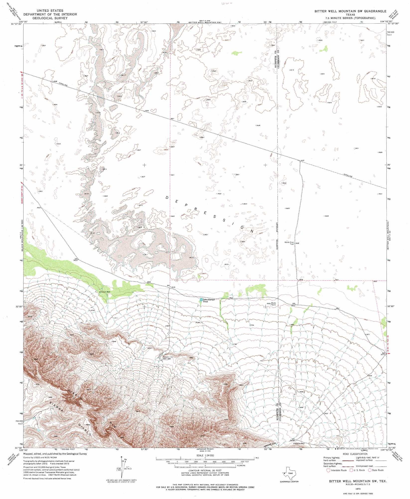
Bitter Well Mountain Sw Topo Map Texas
To zoom in, hover over the map of Bitter Well Mountain Sw
USGS Topo Quad 31104e8 - 1:24,000 scale
| Topo Map Name: | Bitter Well Mountain Sw |
| USGS Topo Quad ID: | 31104e8 |
| Print Size: | ca. 21 1/4" wide x 27" high |
| Southeast Coordinates: | 31.5° N latitude / 104.875° W longitude |
| Map Center Coordinates: | 31.5625° N latitude / 104.9375° W longitude |
| U.S. State: | TX |
| Filename: | o31104e8.jpg |
| Download Map JPG Image: | Bitter Well Mountain Sw topo map 1:24,000 scale |
| Map Type: | Topographic |
| Topo Series: | 7.5´ |
| Map Scale: | 1:24,000 |
| Source of Map Images: | United States Geological Survey (USGS) |
| Alternate Map Versions: |
Bitter Well Mountain SW TX 1973, updated 1976 Download PDF Buy paper map Bitter Well Mountain SW TX 2010 Download PDF Buy paper map Bitter Well Mountain SW TX 2013 Download PDF Buy paper map Bitter Well Mountain SW TX 2016 Download PDF Buy paper map |
1:24,000 Topo Quads surrounding Bitter Well Mountain Sw
Mickey Draw East |
Linda Lake South |
Patterson Hills |
Guadalupe Pass |
Long Point |
Black Mountains Nw |
Salt Flat |
Bitter Well Mountain Nw |
Six Bar Ranch |
Chico Draw West |
Black Mountains |
Babb Canyon |
Bitter Well Mountain Sw |
Bitter Well Mountain |
Burro Canyon |
Norton Mesa |
Sneed Mountain Ne |
Apache Peak |
Figure Two Ranch |
Seven Heart Gap Nw |
Movie Mountain |
Sneed Mountain |
Collier Mesa |
Victorio Peak |
Square Mesa |
> Back to 31104e1 at 1:100,000 scale
> Back to 31104a1 at 1:250,000 scale
> Back to U.S. Topo Maps home
Bitter Well Mountain Sw topo map: Gazetteer
Bitter Well Mountain Sw: Reservoirs
John Garner Tank elevation 1111m 3645′Bitter Well Mountain Sw: Valleys
Apache Canyon elevation 1248m 4094′Bitter Well Mountain Sw: Wells
Apache Well elevation 1244m 4081′Curton Well elevation 1112m 3648′
Fence Line Well elevation 1203m 3946′
North End Tub elevation 1107m 3631′
Sixmile Well elevation 1120m 3674′
Wade Tank elevation 1116m 3661′
Bitter Well Mountain Sw digital topo map on disk
Buy this Bitter Well Mountain Sw topo map showing relief, roads, GPS coordinates and other geographical features, as a high-resolution digital map file on DVD: