Chico Draw West Topo Map Texas
To zoom in, hover over the map of Chico Draw West
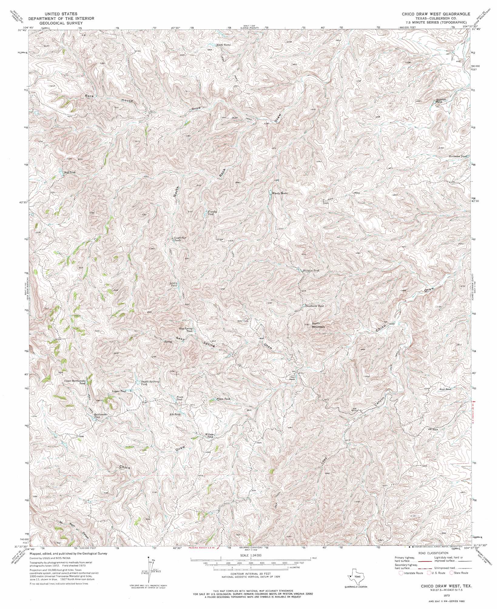
USGS Topo Quad 31104f6 - 1:24,000 scale
| Topo Map Name: | Chico Draw West |
| USGS Topo Quad ID: | 31104f6 |
| Print Size: | ca. 21 1/4" wide x 27" high |
| Southeast Coordinates: | 31.625° N latitude / 104.625° W longitude |
| Map Center Coordinates: | 31.6875° N latitude / 104.6875° W longitude |
| U.S. State: | TX |
| Filename: | o31104f6.jpg |
| Download Map JPG Image: | Chico Draw West topo map 1:24,000 scale |
| Map Type: | Topographic |
| Topo Series: | 7.5´ |
| Map Scale: | 1:24,000 |
| Source of Map Images: | United States Geological Survey (USGS) |
| Alternate Map Versions: |
Chico Draw West TX 1973, updated 1976 Download PDF Buy paper map Chico Draw West TX 2010 Download PDF Buy paper map Chico Draw West TX 2012 Download PDF Buy paper map Chico Draw West TX 2016 Download PDF Buy paper map |
1:24,000 Topo Quads surrounding Chico Draw West
P X Flat |
Guadalupe Peak |
Independence Spring |
South Rector Canyon |
Alligator Draw |
Patterson Hills |
Guadalupe Pass |
Long Point |
Cow Mountain |
Delaware Spring |
Bitter Well Mountain Nw |
Six Bar Ranch |
Chico Draw West |
Chico Draw East |
Seven L Peak |
Bitter Well Mountain Sw |
Bitter Well Mountain |
Burro Canyon |
Emory Corral |
Kc Ranch |
Apache Peak |
Figure Two Ranch |
Seven Heart Gap Nw |
Delaware Ranch |
Loneman Mountain |
> Back to 31104e1 at 1:100,000 scale
> Back to 31104a1 at 1:250,000 scale
> Back to U.S. Topo Maps home
Chico Draw West topo map: Gazetteer
Chico Draw West: Reservoirs
Antelope Tank elevation 1372m 4501′Deadhorse Tank elevation 1493m 4898′
Division Tank elevation 1487m 4878′
Double Spillway Tank elevation 1569m 5147′
East Tank elevation 1466m 4809′
Franky Tank elevation 1515m 4970′
Goodfellow Tanks elevation 1525m 5003′
Horseshoe Tank elevation 1391m 4563′
Logger Tank elevation 1574m 5164′
Lucky Tank elevation 1570m 5150′
North Tanks elevation 1470m 4822′
Paula Tank elevation 1526m 5006′
Piñon Tank elevation 1497m 4911′
Rattlesnake Tank elevation 1574m 5164′
Red Tank elevation 1558m 5111′
Rib Tank elevation 1512m 4960′
Seep Spring Tank elevation 1530m 5019′
Upper Rattlesnake Tank elevation 1613m 5291′
Wilson Tank elevation 1486m 4875′
Windy Tanks elevation 1487m 4878′
Chico Draw West: Summits
North Mountain elevation 1571m 5154′Chico Draw West: Valleys
Leed Canyon elevation 1422m 4665′Rock House Draw elevation 1431m 4694′
Seep Spring Draw elevation 1439m 4721′
Chico Draw West digital topo map on disk
Buy this Chico Draw West topo map showing relief, roads, GPS coordinates and other geographical features, as a high-resolution digital map file on DVD: