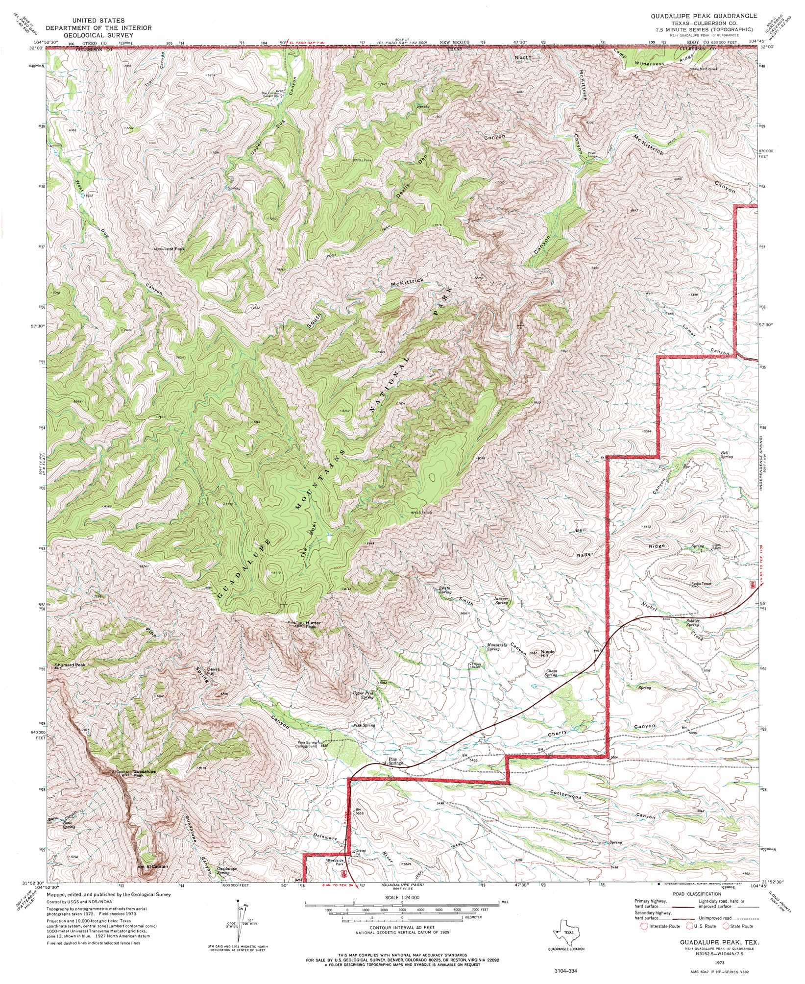
Guadalupe Peak Topo Map Texas
To zoom in, hover over the map of Guadalupe Peak
USGS Topo Quad 31104h7 - 1:24,000 scale
| Topo Map Name: | Guadalupe Peak |
| USGS Topo Quad ID: | 31104h7 |
| Print Size: | ca. 21 1/4" wide x 27" high |
| Southeast Coordinates: | 31.875° N latitude / 104.75° W longitude |
| Map Center Coordinates: | 31.9375° N latitude / 104.8125° W longitude |
| U.S. State: | TX |
| Filename: | o31104h7.jpg |
| Download Map JPG Image: | Guadalupe Peak topo map 1:24,000 scale |
| Map Type: | Topographic |
| Topo Series: | 7.5´ |
| Map Scale: | 1:24,000 |
| Source of Map Images: | United States Geological Survey (USGS) |
| Alternate Map Versions: |
Guadalupe Peak TX 1973, updated 1977 Download PDF Buy paper map Guadalupe Peak TX 2011 Download PDF Buy paper map Guadalupe Peak TX 2013 Download PDF Buy paper map Guadalupe Peak TX 2016 Download PDF Buy paper map |
| FStopo: | US Forest Service topo Guadalupe Peak is available: Download FStopo PDF Download FStopo TIF |
1:24,000 Topo Quads surrounding Guadalupe Peak
Sheep Draw |
La Paloma Canyon |
Pickett Hill |
Queen |
Serpentine Bends |
Cienega School |
Panther Canyon |
El Paso Gap |
Gunsight Canyon |
Grapevine Draw |
Linda Lake North |
P X Flat |
Guadalupe Peak |
Independence Spring |
South Rector Canyon |
Linda Lake South |
Patterson Hills |
Guadalupe Pass |
Long Point |
Cow Mountain |
Salt Flat |
Bitter Well Mountain Nw |
Six Bar Ranch |
Chico Draw West |
Chico Draw East |
> Back to 31104e1 at 1:100,000 scale
> Back to 31104a1 at 1:250,000 scale
> Back to U.S. Topo Maps home
Guadalupe Peak topo map: Gazetteer
Guadalupe Peak: Basins
Devils Hall elevation 1980m 6496′The Bowl elevation 2365m 7759′
Guadalupe Peak: Parks
Guadalupe Mountains National Park elevation 2307m 7568′Guadalupe Peak: Populated Places
Frijole (historical) elevation 1603m 5259′Pine Springs elevation 1717m 5633′
Pinery (historical) elevation 1723m 5652′
Guadalupe Peak: Ranges
Guadalupe Mountains elevation 2657m 8717′Guadalupe Peak: Ridges
Camp Wilderness Ridge elevation 2149m 7050′Rader Ridge elevation 1732m 5682′
Guadalupe Peak: Springs
Bell Spring elevation 1546m 5072′Bone Spring elevation 1677m 5501′
Choza Spring elevation 1613m 5291′
Guadalupe Spring elevation 1798m 5898′
Juniper Spring elevation 1716m 5629′
Manzanita Spring elevation 1688m 5538′
Pine Spring elevation 1759m 5770′
Pine Springs elevation 2262m 7421′
Smith Spring elevation 1817m 5961′
Soldier Spring elevation 1542m 5059′
Upper Pine Spring elevation 1818m 5964′
Guadalupe Peak: Summits
El Capitan elevation 2458m 8064′Guadalupe Peak elevation 2657m 8717′
Hunter Peak elevation 2517m 8257′
Lost Peak elevation 2383m 7818′
Nipple Hill elevation 1725m 5659′
Shumard Peak elevation 2621m 8599′
Guadalupe Peak: Trails
Bowl Trail elevation 2408m 7900′Marcus Trail elevation 2162m 7093′
Tejas Trail elevation 1930m 6332′
Wilderness Ridge - Shumard Trail elevation 2148m 7047′
Guadalupe Peak: Valleys
Devils Den Canyon elevation 1608m 5275′McKittrick Canyon elevation 1523m 4996′
North McKittrick Canyon elevation 1585m 5200′
Pine Spring Canyon elevation 1789m 5869′
Smith Canyon elevation 1643m 5390′
South McKittrick Canyon elevation 1585m 5200′
Guadalupe Peak digital topo map on disk
Buy this Guadalupe Peak topo map showing relief, roads, GPS coordinates and other geographical features, as a high-resolution digital map file on DVD: