Sneed Mountain Ne Topo Map Texas
To zoom in, hover over the map of Sneed Mountain Ne
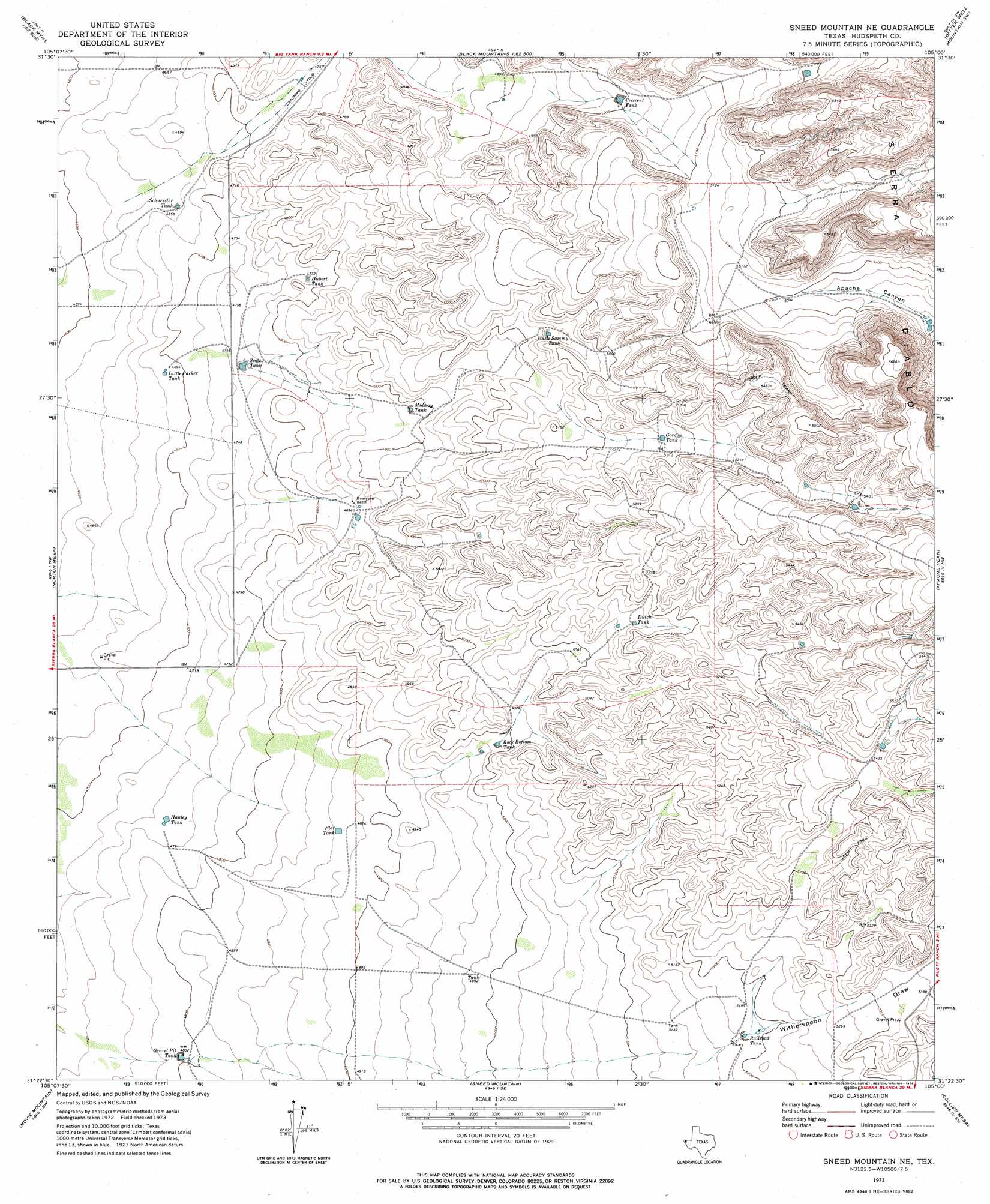
USGS Topo Quad 31105d1 - 1:24,000 scale
| Topo Map Name: | Sneed Mountain Ne |
| USGS Topo Quad ID: | 31105d1 |
| Print Size: | ca. 21 1/4" wide x 27" high |
| Southeast Coordinates: | 31.375° N latitude / 105° W longitude |
| Map Center Coordinates: | 31.4375° N latitude / 105.0625° W longitude |
| U.S. State: | TX |
| Filename: | o31105d1.jpg |
| Download Map JPG Image: | Sneed Mountain Ne topo map 1:24,000 scale |
| Map Type: | Topographic |
| Topo Series: | 7.5´ |
| Map Scale: | 1:24,000 |
| Source of Map Images: | United States Geological Survey (USGS) |
| Alternate Map Versions: |
Sneed Mountain NE TX 1973, updated 1976 Download PDF Buy paper map Sneed Mountain NE TX 2010 Download PDF Buy paper map Sneed Mountain NE TX 2013 Download PDF Buy paper map Sneed Mountain NE TX 2016 Download PDF Buy paper map |
1:24,000 Topo Quads surrounding Sneed Mountain Ne
Hueco Station |
Black Mountains Nw |
Salt Flat |
Bitter Well Mountain Nw |
Six Bar Ranch |
Scratch Ranch |
Black Mountains |
Babb Canyon |
Bitter Well Mountain Sw |
Bitter Well Mountain |
Black Hills |
Norton Mesa |
Sneed Mountain Ne |
Apache Peak |
Figure Two Ranch |
Pierce Ranch |
Movie Mountain |
Sneed Mountain |
Collier Mesa |
Victorio Peak |
Sierra Blanca |
Dome Peak |
Bean Hills |
Sheep Peak |
Nutt Ranch |
> Back to 31105a1 at 1:100,000 scale
> Back to 31104a1 at 1:250,000 scale
> Back to U.S. Topo Maps home
Sneed Mountain Ne topo map: Gazetteer
Sneed Mountain Ne: Reservoirs
Crescent Tank elevation 1524m 5000′Crescent Tank elevation 1525m 5003′
Dutch Tank elevation 1581m 5187′
Dutch Tank elevation 1571m 5154′
Flat Tank elevation 1484m 4868′
Flat Tank elevation 1484m 4868′
Gordon Tank elevation 1576m 5170′
Gordon Tank elevation 1576m 5170′
Gravel Pit Tank elevation 1464m 4803′
Gravel Pit Tank elevation 1464m 4803′
Hanley Tank elevation 1448m 4750′
Hubert Tank elevation 1458m 4783′
Hubert Tank elevation 1460m 4790′
Little Parker Tank elevation 1430m 4691′
Little Parker Tank elevation 1430m 4691′
Midway Tank elevation 1492m 4895′
Midway Tank elevation 1493m 4898′
Railroad Tank elevation 1585m 5200′
Railroad Tank elevation 1581m 5187′
Rock Bottom Tank elevation 1523m 4996′
Schuessler Tank elevation 1421m 4662′
Schuessler Tank elevation 1421m 4662′
Scott Tank elevation 1451m 4760′
Scott Tank elevation 1451m 4760′
Uncle Sammy Tank elevation 1546m 5072′
Sneed Mountain Ne: Valleys
Witherspoon Draw elevation 1574m 5164′Sneed Mountain Ne digital topo map on disk
Buy this Sneed Mountain Ne topo map showing relief, roads, GPS coordinates and other geographical features, as a high-resolution digital map file on DVD: