Adobe House Tank Topo Map Texas
To zoom in, hover over the map of Adobe House Tank
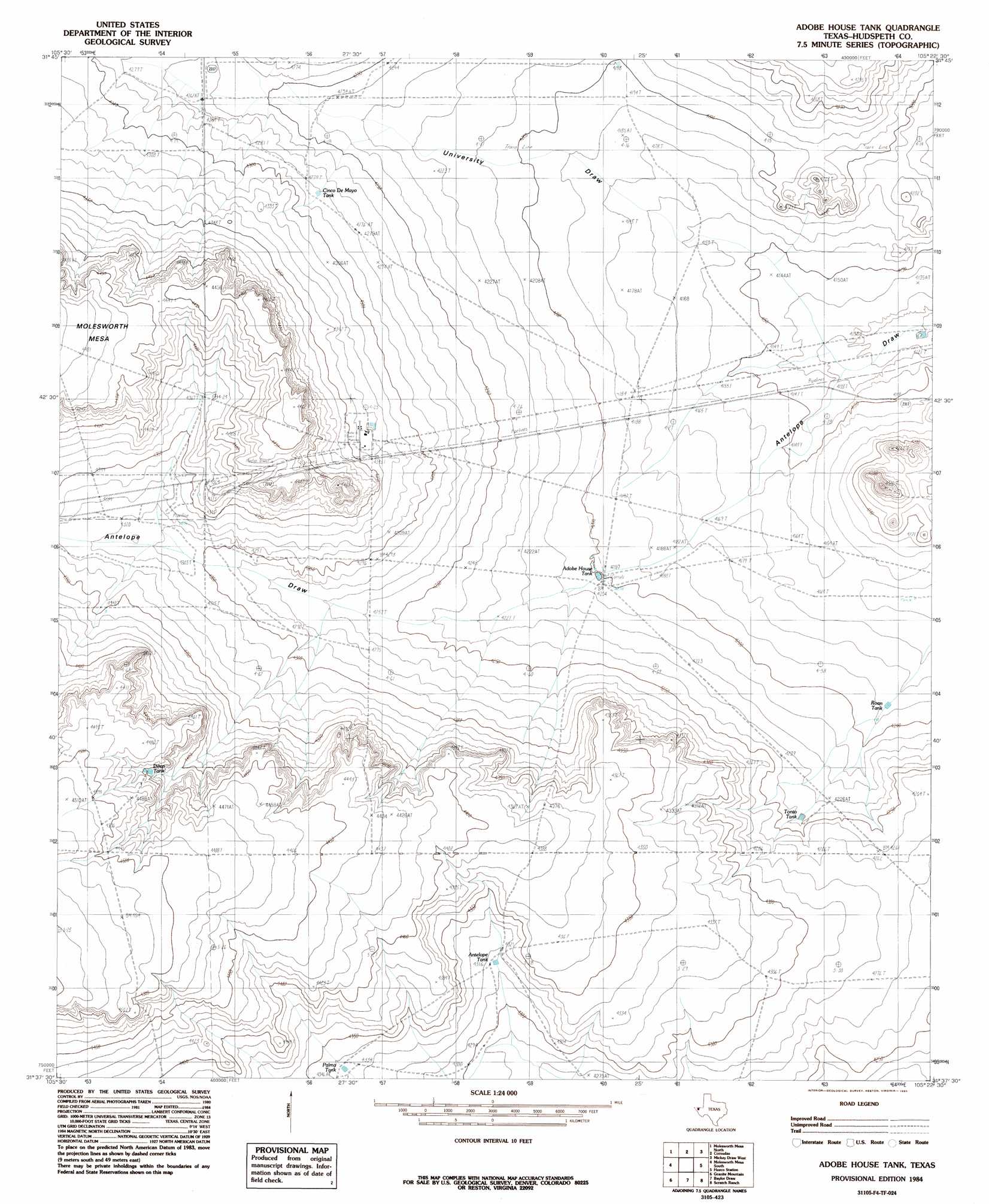
USGS Topo Quad 31105f4 - 1:24,000 scale
| Topo Map Name: | Adobe House Tank |
| USGS Topo Quad ID: | 31105f4 |
| Print Size: | ca. 21 1/4" wide x 27" high |
| Southeast Coordinates: | 31.625° N latitude / 105.375° W longitude |
| Map Center Coordinates: | 31.6875° N latitude / 105.4375° W longitude |
| U.S. State: | TX |
| Filename: | o31105f4.jpg |
| Download Map JPG Image: | Adobe House Tank topo map 1:24,000 scale |
| Map Type: | Topographic |
| Topo Series: | 7.5´ |
| Map Scale: | 1:24,000 |
| Source of Map Images: | United States Geological Survey (USGS) |
| Alternate Map Versions: |
Adobe House Tank TX 1984, updated 1985 Download PDF Buy paper map Adobe House Tank TX 2010 Download PDF Buy paper map Adobe House Tank TX 2012 Download PDF Buy paper map Adobe House Tank TX 2016 Download PDF Buy paper map |
1:24,000 Topo Quads surrounding Adobe House Tank
Big Heiser Tank |
Sixteen Mountains |
Cerro Diablo |
C And L Draw |
Dell City |
Buckhorn Draw East |
Molesworth Mesa North |
Cornudas |
Mickey Draw West |
Mickey Draw East |
Tepee Butte |
Molesworth Mesa South |
Adobe House Tank |
Hueco Station |
Black Mountains Nw |
Tepee Butte Sw |
Granite Mountain |
Baylor Draw |
Scratch Ranch |
Black Mountains |
Diablo Canyon West |
Diablo Canyon East |
Gunsight Hills North |
Black Hills |
Norton Mesa |
> Back to 31105e1 at 1:100,000 scale
> Back to 31104a1 at 1:250,000 scale
> Back to U.S. Topo Maps home
Adobe House Tank topo map: Gazetteer
Adobe House Tank: Reservoirs
Adobe House Tank elevation 1281m 4202′Antelope Tank elevation 1315m 4314′
Cinco De Mayo Tank elevation 1306m 4284′
Deep Tank elevation 1351m 4432′
Llano Tank elevation 1275m 4183′
Palma Tank elevation 1322m 4337′
Roan Tank elevation 1277m 4189′
Tonto Tank elevation 1293m 4242′
Adobe House Tank: Valleys
University Draw elevation 1257m 4124′Adobe House Tank: Wells
Well Number Five elevation 1314m 4311′Adobe House Tank digital topo map on disk
Buy this Adobe House Tank topo map showing relief, roads, GPS coordinates and other geographical features, as a high-resolution digital map file on DVD: