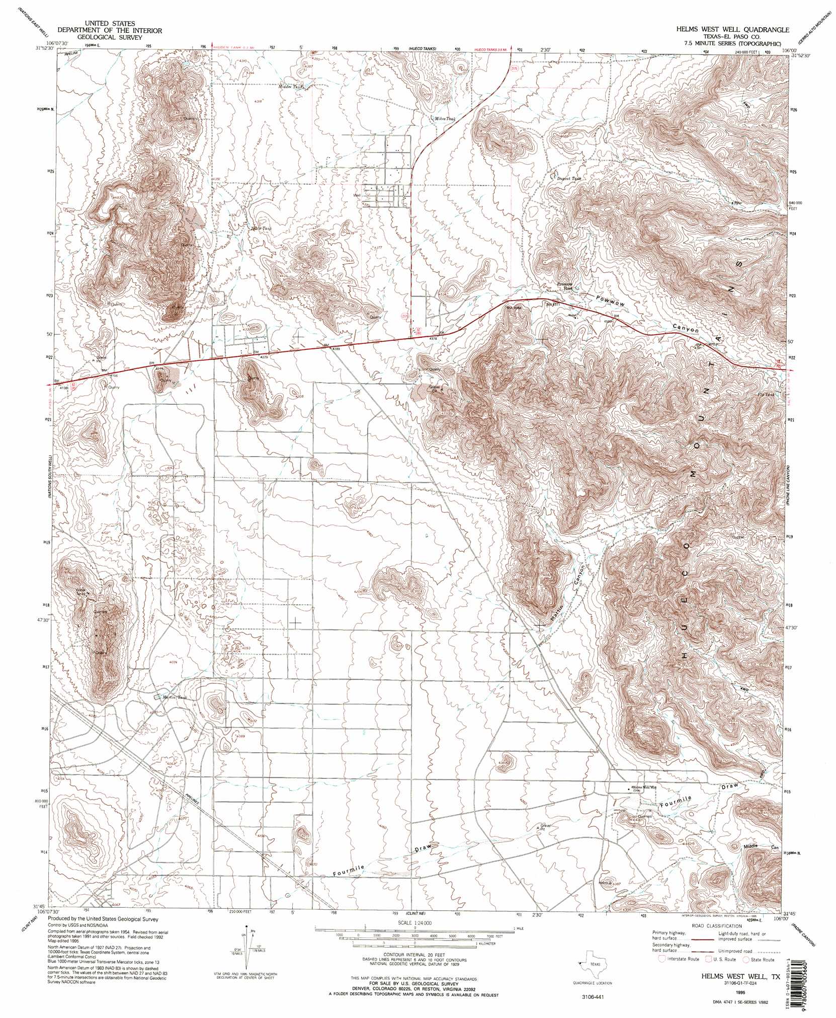
Helms West Well Topo Map Texas
To zoom in, hover over the map of Helms West Well
USGS Topo Quad 31106g1 - 1:24,000 scale
| Topo Map Name: | Helms West Well |
| USGS Topo Quad ID: | 31106g1 |
| Print Size: | ca. 21 1/4" wide x 27" high |
| Southeast Coordinates: | 31.75° N latitude / 106° W longitude |
| Map Center Coordinates: | 31.8125° N latitude / 106.0625° W longitude |
| U.S. State: | TX |
| Filename: | o31106g1.jpg |
| Download Map JPG Image: | Helms West Well topo map 1:24,000 scale |
| Map Type: | Topographic |
| Topo Series: | 7.5´ |
| Map Scale: | 1:24,000 |
| Source of Map Images: | United States Geological Survey (USGS) |
| Alternate Map Versions: |
Helms West Well TX 1948 Download PDF Buy paper map Helms West Well TX 1955, updated 1959 Download PDF Buy paper map Helms West Well TX 1995, updated 1995 Download PDF Buy paper map Helms West Well TX 2010 Download PDF Buy paper map Helms West Well TX 2012 Download PDF Buy paper map Helms West Well TX 2016 Download PDF Buy paper map |
1:24,000 Topo Quads surrounding Helms West Well
Newman |
Desert Sw |
Desert Se |
Mountain Tank |
Alamo Mountain |
Fort Bliss Ne |
Nations East Well |
Hueco Tanks |
Cerro Alto Mountain |
Hobo Tank |
Fort Bliss Se |
Nations South Well |
Helms West Well |
Phone Line Canyon |
Buckhorn Draw West |
Ysleta |
Clint Nw |
Clint Ne |
Padre Canyon |
Wildhorse Draw |
San Elizario |
Clint |
Clint Se |
T P Well |
Whiterock Hills |
> Back to 31106e1 at 1:100,000 scale
> Back to 31106a1 at 1:250,000 scale
> Back to U.S. Topo Maps home
Helms West Well topo map: Gazetteer
Helms West Well: Populated Places
Butterfield elevation 1286m 4219′Butterfield City Number 1 Colonia elevation 1283m 4209′
Butterfield City Number 2 Colonia elevation 1295m 4248′
Butterfield City Number 3 Colonia elevation 1290m 4232′
Butterfield City Number 4 Colonia elevation 1339m 4393′
Hueco Mountain Estates Number 9 Colonia elevation 1353m 4438′
Helms West Well: Reservoirs
Dugout Tank elevation 1393m 4570′Fly Tank elevation 1474m 4835′
Martin Tank elevation 1242m 4074′
Middle Tank elevation 1323m 4340′
Mikes Tank elevation 1352m 4435′
Neals Tank elevation 1311m 4301′
Pow Wow Tank elevation 1384m 4540′
Helms West Well: Valleys
Fourmile Draw elevation 1323m 4340′Martin Canyon elevation 1328m 4356′
Middle Canyon elevation 1347m 4419′
Phone Line Canyon elevation 1340m 4396′
Pow Wow Canyon elevation 1364m 4475′
Helms West Well: Wells
Helms West Well elevation 1323m 4340′Helms West Well digital topo map on disk
Buy this Helms West Well topo map showing relief, roads, GPS coordinates and other geographical features, as a high-resolution digital map file on DVD: