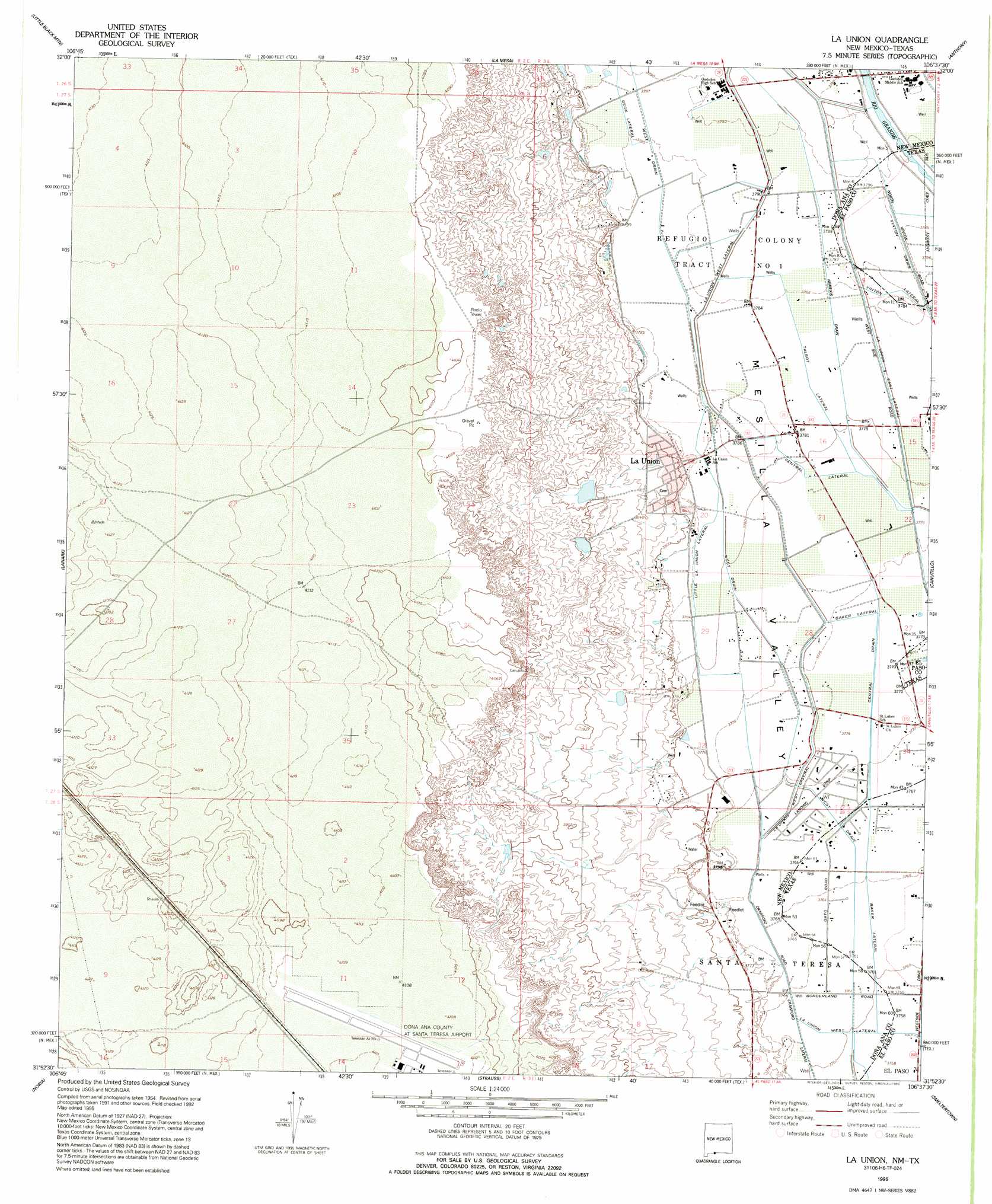
La Union Topo Map New Mexico
To zoom in, hover over the map of La Union
USGS Topo Quad 31106h6 - 1:24,000 scale
| Topo Map Name: | La Union |
| USGS Topo Quad ID: | 31106h6 |
| Print Size: | ca. 21 1/4" wide x 27" high |
| Southeast Coordinates: | 31.875° N latitude / 106.625° W longitude |
| Map Center Coordinates: | 31.9375° N latitude / 106.6875° W longitude |
| U.S. States: | NM, TX |
| Filename: | o31106h6.jpg |
| Download Map JPG Image: | La Union topo map 1:24,000 scale |
| Map Type: | Topographic |
| Topo Series: | 7.5´ |
| Map Scale: | 1:24,000 |
| Source of Map Images: | United States Geological Survey (USGS) |
| Alternate Map Versions: |
La Union NM 1955, updated 1962 Download PDF Buy paper map La Union NM 1955, updated 1962 Download PDF Buy paper map La Union NM 1995, updated 1995 Download PDF Buy paper map La Union NM 1996, updated 2002 Download PDF Buy paper map La Union NM 2010 Download PDF Buy paper map La Union NM 2013 Download PDF Buy paper map La Union NM 2017 Download PDF Buy paper map |
1:24,000 Topo Quads surrounding La Union
Afton Nw |
Black Mesa |
San Miguel |
Bishop Cap |
Newman Nw |
Afton |
Little Black Mountain |
La Mesa |
Anthony |
Newman Sw |
Kilbourne Hole |
Lanark |
La Union |
Canutillo |
North Franklin Mountain |
Potrillo |
Noria |
Strauss |
Smeltertown |
El Paso |
Ysleta Nw |
> Back to 31106e1 at 1:100,000 scale
> Back to 31106a1 at 1:250,000 scale
> Back to U.S. Topo Maps home
La Union topo map: Gazetteer
La Union: Airports
Santa Teresa Airport elevation 1253m 4110′La Union: Canals
Baker Lateral elevation 1148m 3766′Baker Lateral elevation 1149m 3769′
Central Drain elevation 1150m 3772′
Central Lateral elevation 1152m 3779′
La Union East Lateral elevation 1153m 3782′
La Union West Lateral elevation 1154m 3786′
La Union West Lateral elevation 1146m 3759′
Little La Union Lateral elevation 1154m 3786′
Talbot Lateral elevation 1154m 3786′
West Drain elevation 1153m 3782′
La Union: Populated Places
La Union elevation 1158m 3799′La Union Vieja elevation 1177m 3861′
La Union: Wells
10128 Water Well elevation 1156m 3792′10129 Water Well elevation 1155m 3789′
10130 Water Well elevation 1159m 3802′
10131 Water Well elevation 1158m 3799′
10135 Water Well elevation 1152m 3779′
10139 Water Well elevation 1150m 3772′
10162 Water Well elevation 1167m 3828′
La Union Test Water Well elevation 1250m 4101′
NM 4903611 Water Well elevation 1153m 3782′
NM 4903614 Water Well elevation 1151m 3776′
NM 4903-907 Water Well elevation 1149m 3769′
NM4903307 Water Well elevation 1156m 3792′
Q 111 Water Well elevation 1148m 3766′
Q 46 Water Well elevation 1154m 3786′
Q 9 Water Well elevation 1157m 3795′
Q-1 Water Well elevation 1156m 3792′
Q-100 Water Well elevation 1152m 3779′
Q-101 Water Well elevation 1158m 3799′
Q-103 Water Well elevation 1151m 3776′
Q-141 Water Well elevation 1147m 3763′
Q-164 Water Well elevation 1155m 3789′
Q-184 Water Well elevation 1152m 3779′
Q-41 Water Well elevation 1154m 3786′
Q-42 Water Well elevation 1155m 3789′
Q-48 Water Well elevation 1154m 3786′
Q-55 Water Well elevation 1152m 3779′
Q-59 Water Well elevation 1154m 3786′
Q-6 Water Well elevation 1156m 3792′
Q-96 Water Well elevation 1151m 3776′
Q-98 Water Well elevation 1152m 3779′
T-7 Water Well elevation 1152m 3779′
X-7 Water Well elevation 1148m 3766′
La Union digital topo map on disk
Buy this La Union topo map showing relief, roads, GPS coordinates and other geographical features, as a high-resolution digital map file on DVD: