Hatchet Ranch Topo Map New Mexico
To zoom in, hover over the map of Hatchet Ranch
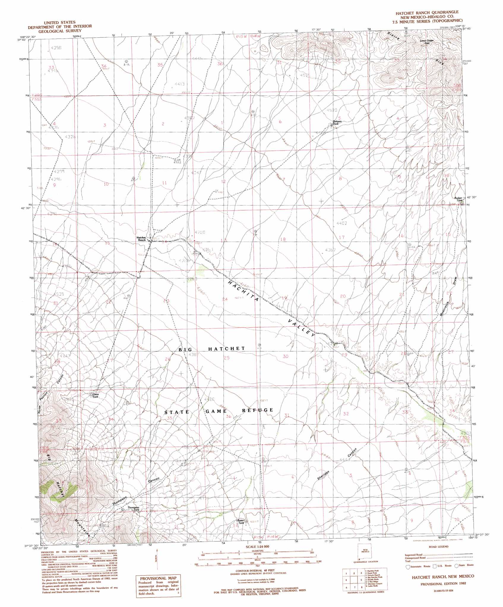
USGS Topo Quad 31108f3 - 1:24,000 scale
| Topo Map Name: | Hatchet Ranch |
| USGS Topo Quad ID: | 31108f3 |
| Print Size: | ca. 21 1/4" wide x 27" high |
| Southeast Coordinates: | 31.625° N latitude / 108.25° W longitude |
| Map Center Coordinates: | 31.6875° N latitude / 108.3125° W longitude |
| U.S. State: | NM |
| Filename: | o31108f3.jpg |
| Download Map JPG Image: | Hatchet Ranch topo map 1:24,000 scale |
| Map Type: | Topographic |
| Topo Series: | 7.5´ |
| Map Scale: | 1:24,000 |
| Source of Map Images: | United States Geological Survey (USGS) |
| Alternate Map Versions: |
Hatchet Ranch NM 1982, updated 1982 Download PDF Buy paper map Hatchet Ranch NM 2010 Download PDF Buy paper map Hatchet Ranch NM 2013 Download PDF Buy paper map Hatchet Ranch NM 2017 Download PDF Buy paper map |
1:24,000 Topo Quads surrounding Hatchet Ranch
Playas Lake North |
Playas Peak |
Hachita |
Hat Top Mountain |
Flying W Mountain |
Playas Lake South |
Hachita Peak |
Doyle Peak |
Victorio Ranch |
Victorio Ranch Se |
Walnut Wells Ne |
Big Hatchet Peak |
Hatchet Ranch |
Double Wells |
|
Horse Mountain |
U Bar Ridge |
Sheridan Canyon |
Cabin Wells |
|
Hilo Peak |
Sentinel Butte |
Pierce Peak |
Campbells Well |
> Back to 31108e1 at 1:100,000 scale
> Back to 31108a1 at 1:250,000 scale
> Back to U.S. Topo Maps home
Hatchet Ranch topo map: Gazetteer
Hatchet Ranch: Arroyos
Muscrath Draw elevation 1296m 4251′Hatchet Ranch: Gaps
Lone Ceder Gap elevation 1512m 4960′Hatchet Ranch: Reservoirs
Badger Tank elevation 1390m 4560′Batter Tank elevation 1403m 4603′
Dishpan Tank elevation 1378m 4520′
Elkins Tank elevation 1423m 4668′
Thompson Tank elevation 1516m 4973′
Hatchet Ranch: Valleys
Dark Canyon elevation 1554m 5098′Horse Pasture Canyon elevation 1412m 4632′
Ram Gorge elevation 1306m 4284′
Sheridan Canyon elevation 1292m 4238′
Thompson Canyon elevation 1348m 4422′
Hatchet Ranch digital topo map on disk
Buy this Hatchet Ranch topo map showing relief, roads, GPS coordinates and other geographical features, as a high-resolution digital map file on DVD: