Mount Baldy Topo Map New Mexico
To zoom in, hover over the map of Mount Baldy
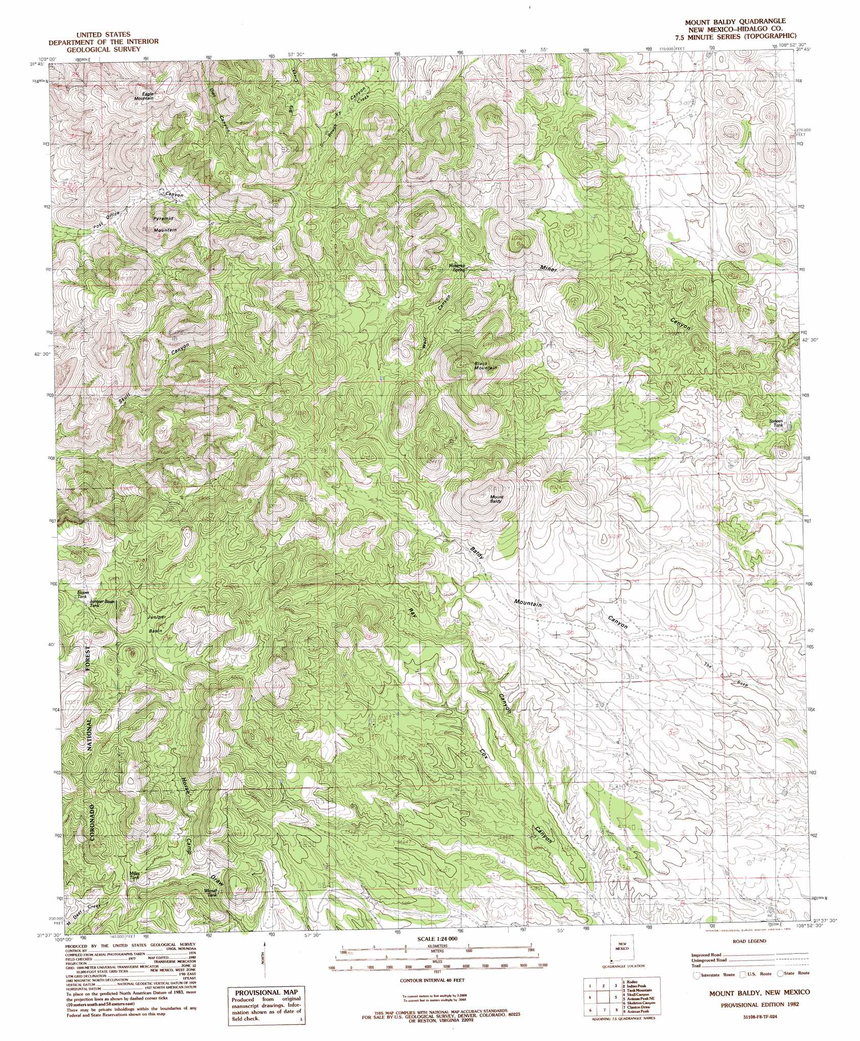
USGS Topo Quad 31108f8 - 1:24,000 scale
| Topo Map Name: | Mount Baldy |
| USGS Topo Quad ID: | 31108f8 |
| Print Size: | ca. 21 1/4" wide x 27" high |
| Southeast Coordinates: | 31.625° N latitude / 108.875° W longitude |
| Map Center Coordinates: | 31.6875° N latitude / 108.9375° W longitude |
| U.S. State: | NM |
| Filename: | o31108f8.jpg |
| Download Map JPG Image: | Mount Baldy topo map 1:24,000 scale |
| Map Type: | Topographic |
| Topo Series: | 7.5´ |
| Map Scale: | 1:24,000 |
| Source of Map Images: | United States Geological Survey (USGS) |
| Alternate Map Versions: |
Mount Baldy NM 1982, updated 1982 Download PDF Buy paper map Mount Baldy NM 1997, updated 2003 Download PDF Buy paper map Mount Baldy NM 2012 Download PDF Buy paper map Mount Baldy NM 2013 Download PDF Buy paper map |
| FStopo: | US Forest Service topo Mount Baldy is available: Download FStopo PDF Download FStopo TIF |
1:24,000 Topo Quads surrounding Mount Baldy
Portal |
Portal Ne |
Antelope Pass |
Animas |
Beacon Hill |
Portal Peak |
Rodeo |
Indian Peak |
Tank Mountain |
Whitmire Pass |
Apache |
Skull Canyon |
Mount Baldy |
Animas Peak Ne |
Gillespie Mountain |
Paramore Crater |
Skeleton Canyon |
Clanton Draw |
Animas Peak |
Center Peak |
Lazy J Ranch |
Guadalupe Spring |
Black Point |
Fitzpatricks |
San Luis Pass |
> Back to 31108e1 at 1:100,000 scale
> Back to 31108a1 at 1:250,000 scale
> Back to U.S. Topo Maps home
Mount Baldy topo map: Gazetteer
Mount Baldy: Basins
Juniper Basin elevation 1767m 5797′Mount Baldy: Populated Places
Eaton Place elevation 1711m 5613′Lovett elevation 1609m 5278′
Lower Lovett Place elevation 1673m 5488′
Mace elevation 1565m 5134′
Old Isaacs Place elevation 1592m 5223′
Upper Lovett Place elevation 1684m 5524′
Mount Baldy: Reservoirs
Juniper Basin Tank elevation 1774m 5820′Miller Tank elevation 1697m 5567′
Slover Tank elevation 1776m 5826′
Wamel Tank elevation 1659m 5442′
Mount Baldy: Springs
Maverick Spring elevation 1640m 5380′Mount Baldy: Summits
Black Mountain elevation 1961m 6433′Eagle Mountain elevation 1923m 6309′
Mount Baldy elevation 2001m 6564′
Pyramid Mountain elevation 1793m 5882′
Mount Baldy: Valleys
Ray Canyon elevation 1562m 5124′Wolf Canyon elevation 1645m 5396′
Mount Baldy digital topo map on disk
Buy this Mount Baldy topo map showing relief, roads, GPS coordinates and other geographical features, as a high-resolution digital map file on DVD: