Hat Top Mountain Topo Map New Mexico
To zoom in, hover over the map of Hat Top Mountain
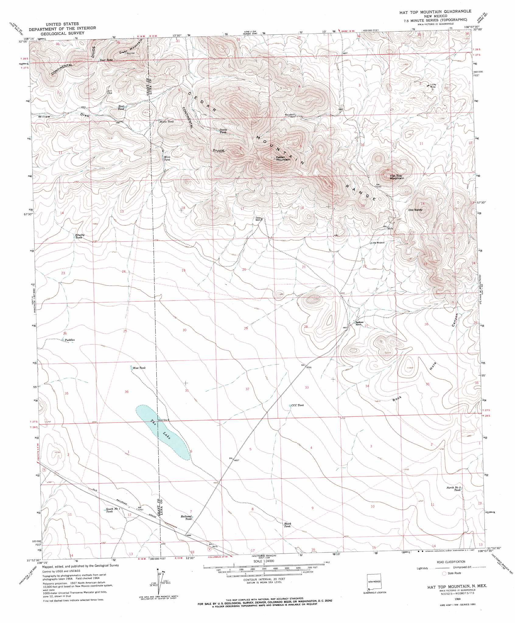
USGS Topo Quad 31108h2 - 1:24,000 scale
| Topo Map Name: | Hat Top Mountain |
| USGS Topo Quad ID: | 31108h2 |
| Print Size: | ca. 21 1/4" wide x 27" high |
| Southeast Coordinates: | 31.875° N latitude / 108.125° W longitude |
| Map Center Coordinates: | 31.9375° N latitude / 108.1875° W longitude |
| U.S. State: | NM |
| Filename: | o31108h2.jpg |
| Download Map JPG Image: | Hat Top Mountain topo map 1:24,000 scale |
| Map Type: | Topographic |
| Topo Series: | 7.5´ |
| Map Scale: | 1:24,000 |
| Source of Map Images: | United States Geological Survey (USGS) |
| Alternate Map Versions: |
Hat Top Mountain NM 1964, updated 1967 Download PDF Buy paper map Hat Top Mountain NM 2010 Download PDF Buy paper map Hat Top Mountain NM 2013 Download PDF Buy paper map Hat Top Mountain NM 2017 Download PDF Buy paper map |
1:24,000 Topo Quads surrounding Hat Top Mountain
Separ |
Separ Ne |
Gage Nw |
Gage |
Red Mountain |
Brockman |
The Saltys |
Gage Sw |
Gage Se |
Bisbee Hills |
Playas Peak |
Hachita |
Hat Top Mountain |
Flying W Mountain |
Hermanas Nw |
Hachita Peak |
Doyle Peak |
Victorio Ranch |
Victorio Ranch Se |
Hermanas |
Big Hatchet Peak |
Hatchet Ranch |
Double Wells |
> Back to 31108e1 at 1:100,000 scale
> Back to 31108a1 at 1:250,000 scale
> Back to U.S. Topo Maps home
Hat Top Mountain topo map: Gazetteer
Hat Top Mountain: Lakes
The Lake elevation 1413m 4635′Hat Top Mountain: Mines
Lucky Mine elevation 1496m 4908′Hat Top Mountain: Parks
Cedar Mountains Wilderness Study Area elevation 1703m 5587′Hat Top Mountain: Reservoirs
Black Tank elevation 1408m 4619′Brushy Tank elevation 1456m 4776′
CCC Tank elevation 1441m 4727′
Deer Tank elevation 1538m 5045′
East Tank elevation 1521m 4990′
Mine Tank elevation 1502m 4927′
Mittle Tank elevation 1548m 5078′
North Number 3 Tank elevation 1456m 4776′
Puddles Tank elevation 1419m 4655′
Railroad Tank elevation 1426m 4678′
Snake Tank elevation 1604m 5262′
South Number 1 Tank elevation 1442m 4730′
West Tank elevation 1414m 4639′
Hat Top Mountain: Summits
Cedar Mountain elevation 1888m 6194′Deer Mountain elevation 1674m 5492′
Hat Top Mountain elevation 1703m 5587′
Old Baldy elevation 1667m 5469′
Hat Top Mountain: Wells
01640 Water Well elevation 1617m 5305′Deep Wells elevation 1499m 4917′
Hat Top Mountain digital topo map on disk
Buy this Hat Top Mountain topo map showing relief, roads, GPS coordinates and other geographical features, as a high-resolution digital map file on DVD: