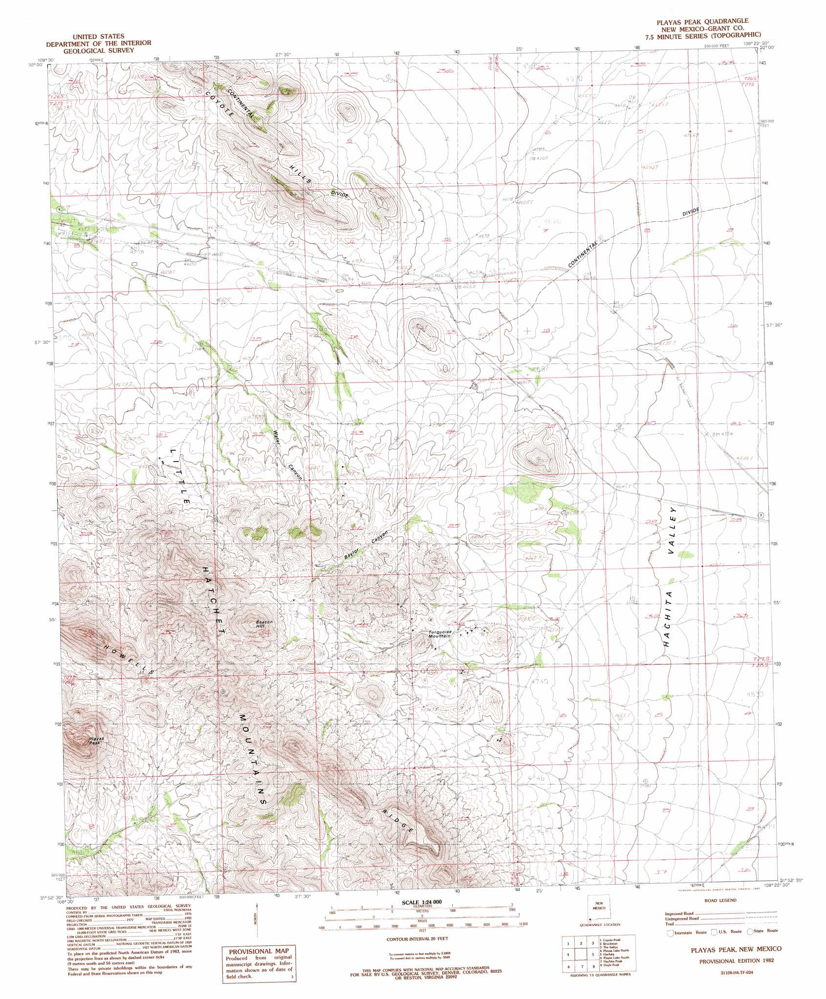
Playas Peak Topo Map New Mexico
To zoom in, hover over the map of Playas Peak
USGS Topo Quad 31108h4 - 1:24,000 scale
| Topo Map Name: | Playas Peak |
| USGS Topo Quad ID: | 31108h4 |
| Print Size: | ca. 21 1/4" wide x 27" high |
| Southeast Coordinates: | 31.875° N latitude / 108.375° W longitude |
| Map Center Coordinates: | 31.9375° N latitude / 108.4375° W longitude |
| U.S. State: | NM |
| Filename: | o31108h4.jpg |
| Download Map JPG Image: | Playas Peak topo map 1:24,000 scale |
| Map Type: | Topographic |
| Topo Series: | 7.5´ |
| Map Scale: | 1:24,000 |
| Source of Map Images: | United States Geological Survey (USGS) |
| Alternate Map Versions: |
Playas Peak NM 1982, updated 1982 Download PDF Buy paper map Playas Peak NM 2010 Download PDF Buy paper map Playas Peak NM 2013 Download PDF Buy paper map Playas Peak NM 2017 Download PDF Buy paper map |
1:24,000 Topo Quads surrounding Playas Peak
Pyramid Peak |
Muir Ranch |
Separ |
Separ Ne |
Gage Nw |
South Pyramid Peak |
Coyote Peak |
Brockman |
The Saltys |
Gage Sw |
Beacon Hill |
Playas Lake North |
Playas Peak |
Hachita |
Hat Top Mountain |
Whitmire Pass |
Playas Lake South |
Hachita Peak |
Doyle Peak |
Victorio Ranch |
Gillespie Mountain |
Walnut Wells Ne |
Big Hatchet Peak |
Hatchet Ranch |
Double Wells |
> Back to 31108e1 at 1:100,000 scale
> Back to 31108a1 at 1:250,000 scale
> Back to U.S. Topo Maps home
Playas Peak topo map: Gazetteer
Playas Peak: Mines
Hornet Mine elevation 1442m 4730′Hornet Mine elevation 1461m 4793′
Howard Shaft elevation 1485m 4872′
King 400 Mine elevation 1489m 4885′
Miss Pickle Tunnel elevation 1571m 5154′
Old Hachita Mine elevation 1457m 4780′
Silver Bell elevation 1469m 4819′
Playas Peak: Populated Places
Minero elevation 1378m 4520′Old Hachita elevation 1478m 4849′
Pothook elevation 1387m 4550′
Vista elevation 1428m 4685′
Playas Peak: Ridges
Howells Ridge elevation 1637m 5370′Playas Peak: Summits
Beacon Hill elevation 1718m 5636′Playas Peak elevation 1756m 5761′
Turquoise Mountain elevation 1513m 4963′
Playas Peak: Valleys
Baylor Canyon elevation 1464m 4803′Water Canyon elevation 1440m 4724′
Playas Peak digital topo map on disk
Buy this Playas Peak topo map showing relief, roads, GPS coordinates and other geographical features, as a high-resolution digital map file on DVD: