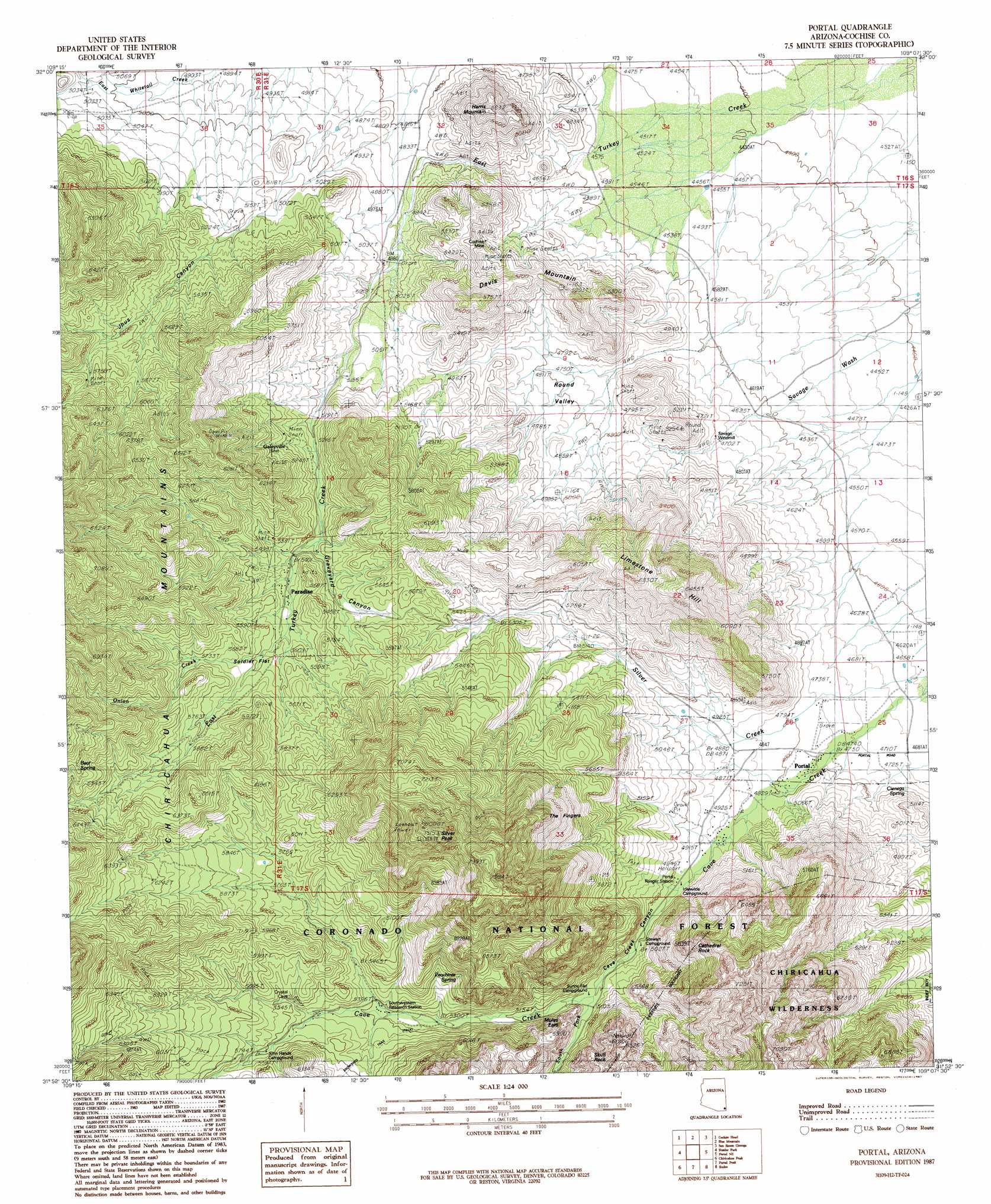
Portal Topo Map Arizona
To zoom in, hover over the map of Portal
USGS Topo Quad 31109h2 - 1:24,000 scale
| Topo Map Name: | Portal |
| USGS Topo Quad ID: | 31109h2 |
| Print Size: | ca. 21 1/4" wide x 27" high |
| Southeast Coordinates: | 31.875° N latitude / 109.125° W longitude |
| Map Center Coordinates: | 31.9375° N latitude / 109.1875° W longitude |
| U.S. State: | AZ |
| Filename: | o31109h2.jpg |
| Download Map JPG Image: | Portal topo map 1:24,000 scale |
| Map Type: | Topographic |
| Topo Series: | 7.5´ |
| Map Scale: | 1:24,000 |
| Source of Map Images: | United States Geological Survey (USGS) |
| Alternate Map Versions: |
Portal AZ 1987, updated 1987 Download PDF Buy paper map Portal AZ 1987, updated 1987 Download PDF Buy paper map Portal AZ 1998, updated 2003 Download PDF Buy paper map Portal AZ 2012 Download PDF Buy paper map Portal AZ 2014 Download PDF Buy paper map |
| FStopo: | US Forest Service topo Portal is available: Download FStopo PDF Download FStopo TIF |
1:24,000 Topo Quads surrounding Portal
Bowie Mountain North |
Little Wood Canyon |
Vanar Nw |
Vanar |
Steins |
Bowie Mountain South |
Cochise Head |
Blue Mountain |
San Simon Cienega |
Cotton City |
Fife Peak |
Rustler Park |
Portal |
Portal Ne |
Antelope Pass |
Stanford Canyon |
Chiricahua Peak |
Portal Peak |
Rodeo |
Indian Peak |
Bruno Peak |
Swede Peak |
Apache |
Skull Canyon |
Mount Baldy |
> Back to 31109e1 at 1:100,000 scale
> Back to 31108a1 at 1:250,000 scale
> Back to U.S. Topo Maps home
Portal topo map: Gazetteer
Portal: Mines
Cochise Mine elevation 1504m 4934′Portal: Parks
Cave Creek Regional Park elevation 1537m 5042′John Hands Picnic Ground elevation 1744m 5721′
Sunny Flat Picnic Ground elevation 1563m 5127′
Portal: Populated Places
Galeyville elevation 1747m 5731′Paradise elevation 1671m 5482′
Portal elevation 1451m 4760′
Portal: Reservoirs
Chiricahua Tank elevation 1775m 5823′Silver Tank elevation 1636m 5367′
Portal: Springs
Cienega Spring elevation 1450m 4757′Hummingbird Spring elevation 1675m 5495′
Peach Tree Spring elevation 1699m 5574′
Portal: Streams
East Turkey Creek elevation 1306m 4284′Onion Creek elevation 1695m 5561′
Silver Creek elevation 0m 0′
South Fork Cave Creek elevation 1553m 5095′
Portal: Summits
Cathedral Rock elevation 1977m 6486′Davis Mountain elevation 1744m 5721′
Harris Mountain elevation 1712m 5616′
Mount Sceloporus elevation 2413m 7916′
Silver Peak elevation 0m 0′
Portal: Valleys
Cave Creek Canyon elevation 1510m 4954′Jhus Canyon elevation 1568m 5144′
Round Valley elevation 0m 0′
Portal digital topo map on disk
Buy this Portal topo map showing relief, roads, GPS coordinates and other geographical features, as a high-resolution digital map file on DVD: