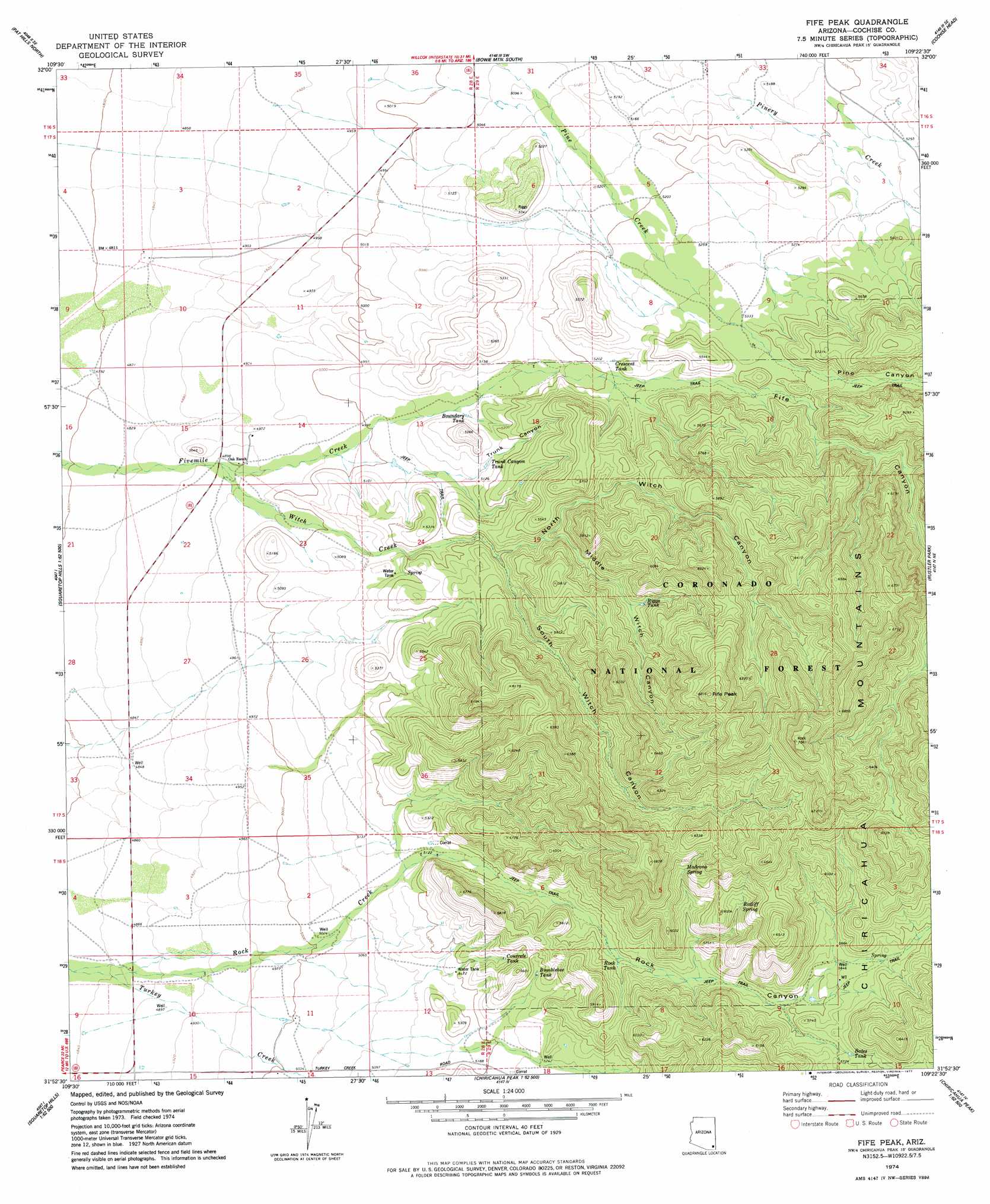
Fife Peak Topo Map Arizona
To zoom in, hover over the map of Fife Peak
USGS Topo Quad 31109h4 - 1:24,000 scale
| Topo Map Name: | Fife Peak |
| USGS Topo Quad ID: | 31109h4 |
| Print Size: | ca. 21 1/4" wide x 27" high |
| Southeast Coordinates: | 31.875° N latitude / 109.375° W longitude |
| Map Center Coordinates: | 31.9375° N latitude / 109.4375° W longitude |
| U.S. State: | AZ |
| Filename: | o31109h4.jpg |
| Download Map JPG Image: | Fife Peak topo map 1:24,000 scale |
| Map Type: | Topographic |
| Topo Series: | 7.5´ |
| Map Scale: | 1:24,000 |
| Source of Map Images: | United States Geological Survey (USGS) |
| Alternate Map Versions: |
Fife Peak AZ 1974, updated 1977 Download PDF Buy paper map Fife Peak AZ 1996, updated 2003 Download PDF Buy paper map Fife Peak AZ 2012 Download PDF Buy paper map Fife Peak AZ 2014 Download PDF Buy paper map |
| FStopo: | US Forest Service topo Fife Peak is available: Download FStopo PDF Download FStopo TIF |
1:24,000 Topo Quads surrounding Fife Peak
Simmons Peak |
Dos Cabezas |
Bowie Mountain North |
Little Wood Canyon |
Vanar Nw |
Dos Cabezas Sw |
Pat Hills North |
Bowie Mountain South |
Cochise Head |
Blue Mountain |
Sulphur Hills |
Pat Hills South |
Fife Peak |
Rustler Park |
Portal |
Squaretop Hills West |
Squaretop Hills East |
Stanford Canyon |
Chiricahua Peak |
Portal Peak |
Elfrida |
Swisshelm Mountain |
Bruno Peak |
Swede Peak |
Apache |
> Back to 31109e1 at 1:100,000 scale
> Back to 31108a1 at 1:250,000 scale
> Back to U.S. Topo Maps home
Fife Peak topo map: Gazetteer
Fife Peak: Ranges
Chiricahua Mountains elevation 1984m 6509′Fife Peak: Reservoirs
Baldridge Tank elevation 1720m 5643′Bates Tank elevation 1743m 5718′
Boundary Tank elevation 1548m 5078′
Bumblebee Tank elevation 1625m 5331′
Concrete Tank elevation 1611m 5285′
Crescent Tank elevation 1594m 5229′
Riggs Tank elevation 1672m 5485′
Rock Tank elevation 1639m 5377′
Trunk Canyon Tank elevation 1561m 5121′
Fife Peak: Springs
Madrono Spring elevation 1795m 5889′Ratliff Spring elevation 1782m 5846′
Fife Peak: Streams
Rock Creek elevation 1470m 4822′Witch Creek elevation 1492m 4895′
Fife Peak: Summits
Fife Peak elevation 2072m 6797′Fife Peak: Trails
Fife Canyon Trail Two Hundred Fiftyeight elevation 1760m 5774′Witch Canyon Trail Two Hundred Sixty elevation 1753m 5751′
Fife Peak: Valleys
Fife Canyon elevation 1570m 5150′Middle Witch Canyon elevation 1612m 5288′
North Witch Canyon elevation 1582m 5190′
Pine Canyon elevation 1630m 5347′
Rock Canyon elevation 1557m 5108′
South Witch Canyon elevation 1582m 5190′
Trunk Canyon elevation 1544m 5065′
Fife Peak digital topo map on disk
Buy this Fife Peak topo map showing relief, roads, GPS coordinates and other geographical features, as a high-resolution digital map file on DVD: