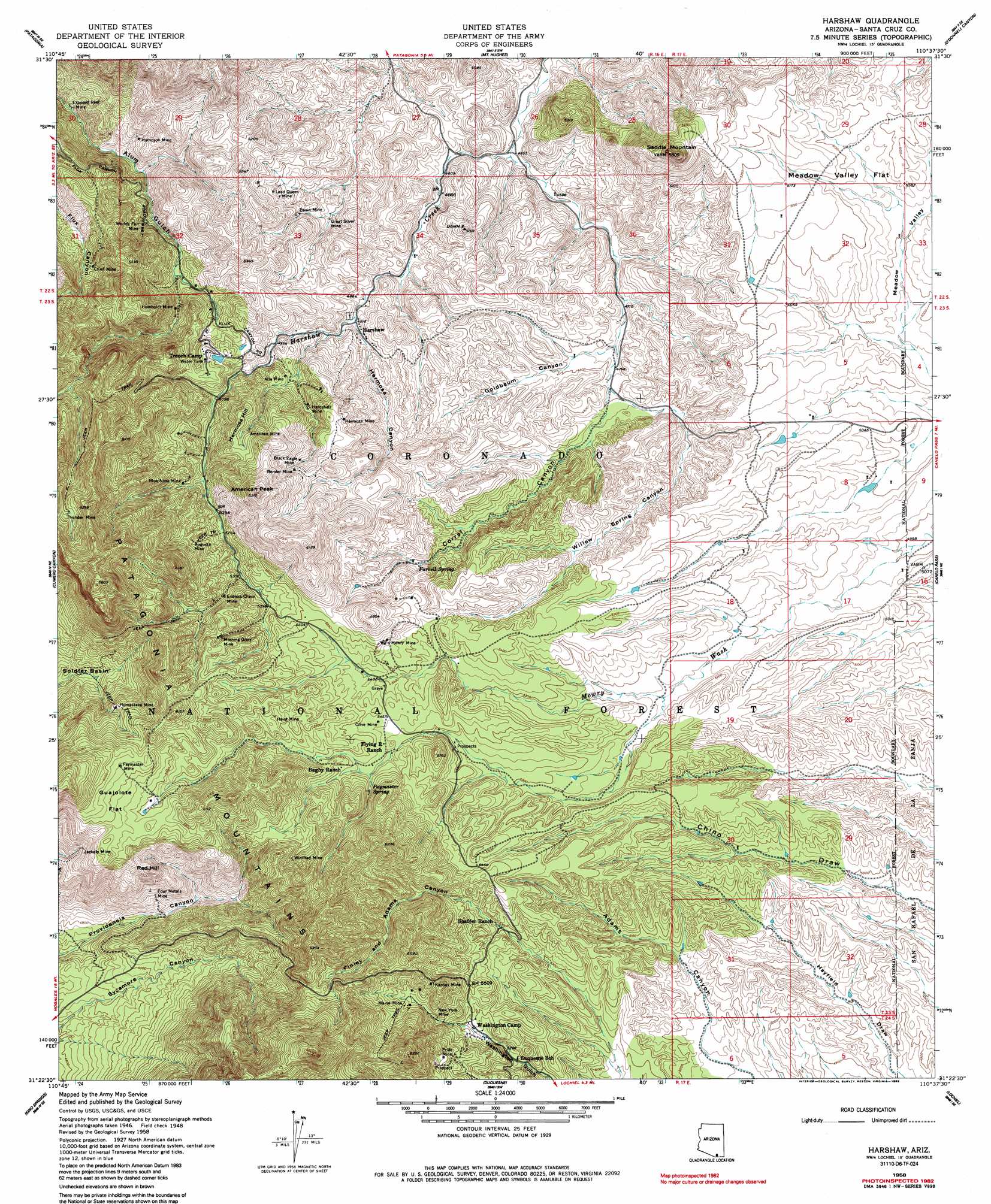
Harshaw Topo Map Arizona
To zoom in, hover over the map of Harshaw
USGS Topo Quad 31110d6 - 1:24,000 scale
| Topo Map Name: | Harshaw |
| USGS Topo Quad ID: | 31110d6 |
| Print Size: | ca. 21 1/4" wide x 27" high |
| Southeast Coordinates: | 31.375° N latitude / 110.625° W longitude |
| Map Center Coordinates: | 31.4375° N latitude / 110.6875° W longitude |
| U.S. State: | AZ |
| Filename: | o31110d6.jpg |
| Download Map JPG Image: | Harshaw topo map 1:24,000 scale |
| Map Type: | Topographic |
| Topo Series: | 7.5´ |
| Map Scale: | 1:24,000 |
| Source of Map Images: | United States Geological Survey (USGS) |
| Alternate Map Versions: |
Harshaw AZ 1948, updated 1953 Download PDF Buy paper map Harshaw AZ 1958, updated 1959 Download PDF Buy paper map Harshaw AZ 1958, updated 1963 Download PDF Buy paper map Harshaw AZ 1958, updated 1985 Download PDF Buy paper map Harshaw AZ 1996, updated 2003 Download PDF Buy paper map Harshaw AZ 2012 Download PDF Buy paper map Harshaw AZ 2014 Download PDF Buy paper map |
| FStopo: | US Forest Service topo Harshaw is available: Download FStopo PDF Download FStopo TIF |
1:24,000 Topo Quads surrounding Harshaw
Mount Hopkins |
Mount Wrightson |
Sonoita |
Elgin |
Mustang Mountains |
San Cayetano Mountains |
Patagonia |
Mount Hughes |
O'Donnel Canyon |
Pyeatt Ranch |
Rio Rico |
Cumero Canyon |
Harshaw |
Canelo Pass |
Huachuca Peak |
Nogales |
Kino Springs |
Duquesne |
Lochiel |
Campini Mesa |
> Back to 31110a1 at 1:100,000 scale
> Back to 31110a1 at 1:250,000 scale
> Back to U.S. Topo Maps home
Harshaw topo map: Gazetteer
Harshaw: Flats
Guajolote Flat elevation 1792m 5879′Meadow Valley Flat elevation 1564m 5131′
Harshaw: Mines
Alta Mine elevation 1555m 5101′Alto Mine elevation 1578m 5177′
American Mine elevation 1660m 5446′
Augusta Mine elevation 1674m 5492′
Basin Mine elevation 1472m 4829′
Bender Mine elevation 1675m 5495′
Black Eagle Mine elevation 1662m 5452′
Blue Nose Mine elevation 1615m 5298′
Boundary Mine (historical) elevation 1723m 5652′
Chief Mine elevation 1557m 5108′
Endless Chain Mine elevation 1646m 5400′
Exposed Reef Mine elevation 1348m 4422′
Four Metals Mine elevation 1549m 5082′
Great Silver Mine elevation 1436m 4711′
Haist Mine elevation 1713m 5620′
Hampson Mine elevation 1397m 4583′
Hardshell Mine elevation 1593m 5226′
Hermosa Mine elevation 1656m 5433′
Homestake Mine elevation 1718m 5636′
Humboldt Mine elevation 1483m 4865′
Jackalo Mine elevation 1703m 5587′
Kansas Mine elevation 1754m 5754′
Lead Queen Mine elevation 1485m 4872′
Maine Mine elevation 1693m 5554′
Morning Glory Mine elevation 1712m 5616′
Mowry Mine elevation 1666m 5465′
New York Mine elevation 1669m 5475′
Olive Mine elevation 1666m 5465′
Paymaster Mine elevation 1814m 5951′
Pride Mine elevation 1697m 5567′
Thunder Mine elevation 1802m 5912′
Winifred Mine elevation 1764m 5787′
Worlds Fair Mine elevation 1474m 4835′
Harshaw: Populated Places
Harshaw elevation 1485m 4872′Trench Camp elevation 1592m 5223′
Washington Camp elevation 1643m 5390′
Harshaw: Ranges
Patagonia Mountains elevation 1775m 5823′Harshaw: Reservoirs
AJ Tank elevation 1580m 5183′Apache Tank elevation 1595m 5232′
Bennett Tank elevation 1516m 4973′
Chino Seven Tank elevation 1541m 5055′
Chino Tank elevation 1565m 5134′
Double F Tank elevation 1524m 5000′
Earthen Pond elevation 1615m 5298′
East Three Tank elevation 1513m 4963′
East Two Tank elevation 1494m 4901′
Grennan Tank elevation 1612m 5288′
Heifer Tank elevation 1584m 5196′
Lower Four Tank elevation 1529m 5016′
Middle Two Tank elevation 1507m 4944′
North Eight Tank elevation 1529m 5016′
North Six Tank elevation 1543m 5062′
Number Three Tanks elevation 1561m 5121′
Number Two Tank elevation 1629m 5344′
Pigeon Tank elevation 1514m 4967′
Ridge Tank elevation 1651m 5416′
Seven Tank elevation 1542m 5059′
Tungo Tank elevation 1497m 4911′
Upper Four Tank elevation 1559m 5114′
West Nine Tank elevation 1509m 4950′
West Six Tank elevation 1555m 5101′
West Two Tank elevation 1516m 4973′
Harshaw: Springs
Farrell Spring elevation 1586m 5203′Miller Spring elevation 1694m 5557′
Paymaster Spring elevation 1694m 5557′
Harshaw: Summits
American Peak elevation 1878m 6161′Hermosa Hill elevation 1695m 5561′
Red Hill elevation 1749m 5738′
Saddle Mountain elevation 1771m 5810′
Harshaw: Trails
Thunder Mine Road elevation 1808m 5931′Harshaw: Valleys
Corral Canyon elevation 1464m 4803′Finley and Adams Canyon elevation 1543m 5062′
Goldbaum Canyon elevation 1449m 4753′
Hermosa Canyon elevation 1469m 4819′
Meadow Valley elevation 1513m 4963′
Willow Spring Canyon elevation 1464m 4803′
Harshaw digital topo map on disk
Buy this Harshaw topo map showing relief, roads, GPS coordinates and other geographical features, as a high-resolution digital map file on DVD: