Pyeatt Ranch Topo Map Arizona
To zoom in, hover over the map of Pyeatt Ranch
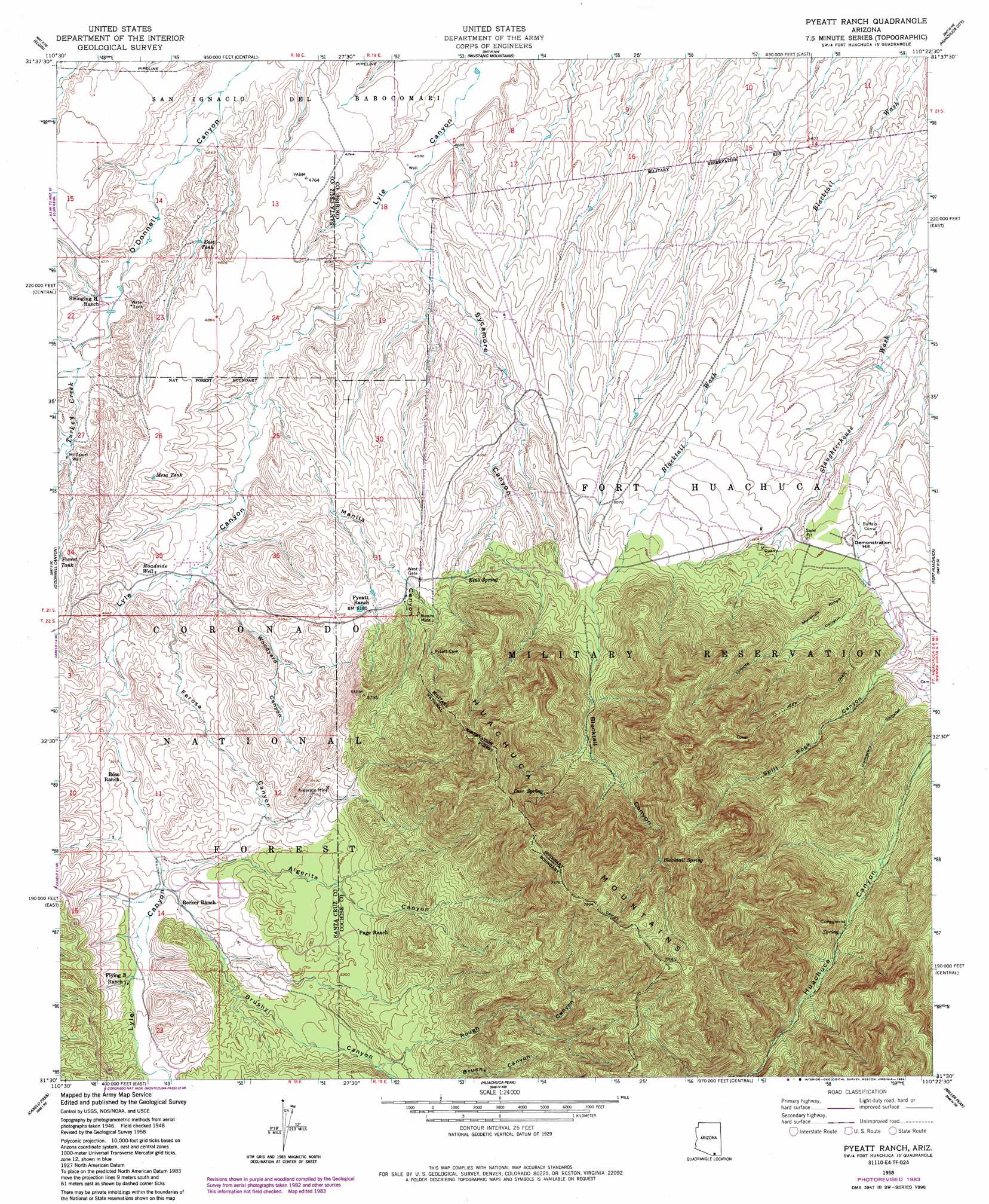
USGS Topo Quad 31110e4 - 1:24,000 scale
| Topo Map Name: | Pyeatt Ranch |
| USGS Topo Quad ID: | 31110e4 |
| Print Size: | ca. 21 1/4" wide x 27" high |
| Southeast Coordinates: | 31.5° N latitude / 110.375° W longitude |
| Map Center Coordinates: | 31.5625° N latitude / 110.4375° W longitude |
| U.S. State: | AZ |
| Filename: | o31110e4.jpg |
| Download Map JPG Image: | Pyeatt Ranch topo map 1:24,000 scale |
| Map Type: | Topographic |
| Topo Series: | 7.5´ |
| Map Scale: | 1:24,000 |
| Source of Map Images: | United States Geological Survey (USGS) |
| Alternate Map Versions: |
Fort Huachuca SW AZ 1948, updated 1953 Download PDF Buy paper map Pyeatt Ranch AZ 1958, updated 1959 Download PDF Buy paper map Pyeatt Ranch AZ 1958, updated 1963 Download PDF Buy paper map Pyeatt Ranch AZ 1958, updated 1984 Download PDF Buy paper map Pyeatt Ranch AZ 1996, updated 2002 Download PDF Buy paper map Pyeatt Ranch AZ 2012 Download PDF Buy paper map Pyeatt Ranch AZ 2014 Download PDF Buy paper map |
| FStopo: | US Forest Service topo Pyeatt Ranch is available: Download FStopo PDF Download FStopo TIF |
1:24,000 Topo Quads surrounding Pyeatt Ranch
Empire Ranch |
Spring Water Canyon |
Apache Peak |
Mcgrew Spring |
Land |
Sonoita |
Elgin |
Mustang Mountains |
Huachuca City |
Fairbank |
Mount Hughes |
O'Donnel Canyon |
Pyeatt Ranch |
Fort Huachuca |
Lewis Springs |
Harshaw |
Canelo Pass |
Huachuca Peak |
Miller Peak |
Nicksville |
Duquesne |
Lochiel |
Campini Mesa |
Montezuma Pass |
Bob Thompson Peak |
> Back to 31110e1 at 1:100,000 scale
> Back to 31110a1 at 1:250,000 scale
> Back to U.S. Topo Maps home
Pyeatt Ranch topo map: Gazetteer
Pyeatt Ranch: Mines
Anderson Mine elevation 1627m 5337′Manila Mine elevation 1604m 5262′
Pyeatt Ranch: Reservoirs
East Tank elevation 1443m 4734′Finley Tank elevation 1435m 4708′
Mesa Tank elevation 1493m 4898′
Pyeatt Tank elevation 1576m 5170′
Pyeatt Ranch: Ridges
Laundry Ridge elevation 1516m 4973′Marshall Ridge elevation 1600m 5249′
Pyeatt Ranch: Springs
Blacktail Spring elevation 2057m 6748′Deer Spring elevation 1894m 6213′
Kino Spring elevation 1571m 5154′
Pyeatt Ranch: Streams
Turkey Creek elevation 1436m 4711′Pyeatt Ranch: Summits
Demonstration Hill elevation 1509m 4950′Pyeatt Ranch: Valleys
Algerita Canyon elevation 1534m 5032′Blacktail Canyon elevation 1546m 5072′
Brushy Canyon elevation 1641m 5383′
Cemetery Canyon elevation 1584m 5196′
Coyote Canyon elevation 1516m 4973′
Ferosa Canyon elevation 1478m 4849′
Manila Canyon elevation 1448m 4750′
Rough Canyon elevation 1643m 5390′
Split Rock Canyon elevation 1596m 5236′
Sycamore Canyon elevation 1408m 4619′
Sycamore Gulch elevation 1407m 4616′
Woodyard Canyon elevation 1475m 4839′
Pyeatt Ranch: Wells
McDaniel Well elevation 1454m 4770′Roadside Well elevation 1482m 4862′
Pyeatt Ranch digital topo map on disk
Buy this Pyeatt Ranch topo map showing relief, roads, GPS coordinates and other geographical features, as a high-resolution digital map file on DVD: