Knob Hill Topo Map Arizona
To zoom in, hover over the map of Knob Hill
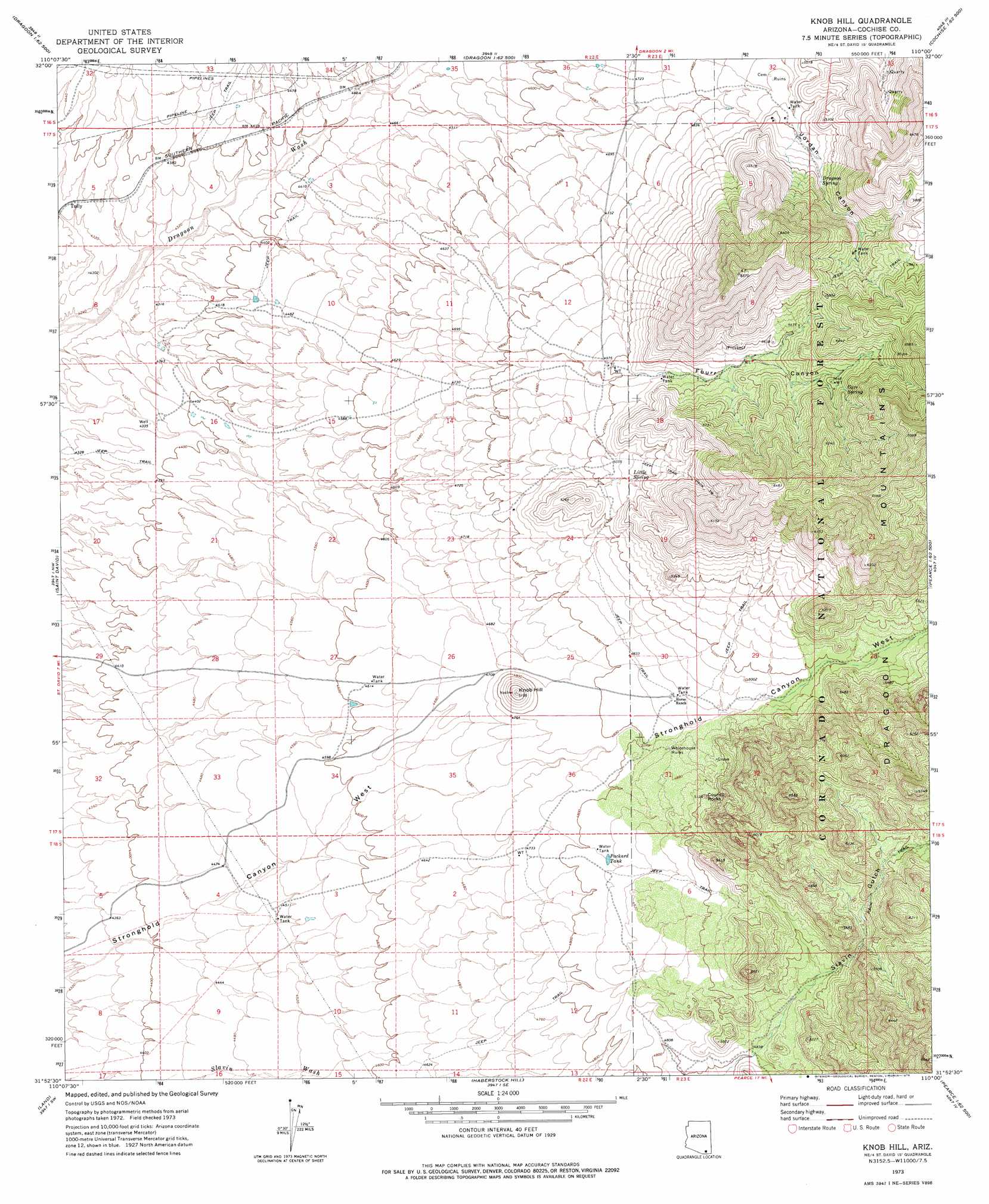
USGS Topo Quad 31110h1 - 1:24,000 scale
| Topo Map Name: | Knob Hill |
| USGS Topo Quad ID: | 31110h1 |
| Print Size: | ca. 21 1/4" wide x 27" high |
| Southeast Coordinates: | 31.875° N latitude / 110° W longitude |
| Map Center Coordinates: | 31.9375° N latitude / 110.0625° W longitude |
| U.S. State: | AZ |
| Filename: | o31110h1.jpg |
| Download Map JPG Image: | Knob Hill topo map 1:24,000 scale |
| Map Type: | Topographic |
| Topo Series: | 7.5´ |
| Map Scale: | 1:24,000 |
| Source of Map Images: | United States Geological Survey (USGS) |
| Alternate Map Versions: |
Knob Hill AZ 1973, updated 1976 Download PDF Buy paper map Knob Hill AZ 1973, updated 1976 Download PDF Buy paper map Knob Hill AZ 1997, updated 2002 Download PDF Buy paper map Knob Hill AZ 2012 Download PDF Buy paper map Knob Hill AZ 2014 Download PDF Buy paper map |
| FStopo: | US Forest Service topo Knob Hill is available: Download FStopo PDF Download FStopo TIF |
1:24,000 Topo Quads surrounding Knob Hill
Wildhorse Mountain |
Deepwell Ranch |
Steele Hills |
Red Bird Hills |
Willcox South |
Galleta Flat East |
San Pedro Ranch |
Dragoon |
Cochise |
Sulphur Spring |
Benson |
Saint David |
Knob Hill |
Cochise Stronghold |
Pearce |
Mcgrew Spring |
Land |
Haberstock Hill |
Black Diamond Peak |
Turquoise Mountain |
Huachuca City |
Fairbank |
Tombstone |
Hay Mountain |
Outlaw Mountain |
> Back to 31110e1 at 1:100,000 scale
> Back to 31110a1 at 1:250,000 scale
> Back to U.S. Topo Maps home
Knob Hill topo map: Gazetteer
Knob Hill: Pillars
Council Rocks elevation 1551m 5088′Knob Hill: Populated Places
Tully elevation 1321m 4333′Knob Hill: Reservoirs
Packard Tank elevation 1473m 4832′Knob Hill: Springs
Cave Spring elevation 1741m 5711′Dragoon Spring elevation 1571m 5154′
Little Spring elevation 1559m 5114′
Knob Hill: Summits
Knob Hill elevation 1550m 5085′Knob Hill: Valleys
Fourr Canyon elevation 1530m 5019′Slavin Gulch elevation 1467m 4812′
Knob Hill digital topo map on disk
Buy this Knob Hill topo map showing relief, roads, GPS coordinates and other geographical features, as a high-resolution digital map file on DVD: