Murphy Peak Topo Map Arizona
To zoom in, hover over the map of Murphy Peak
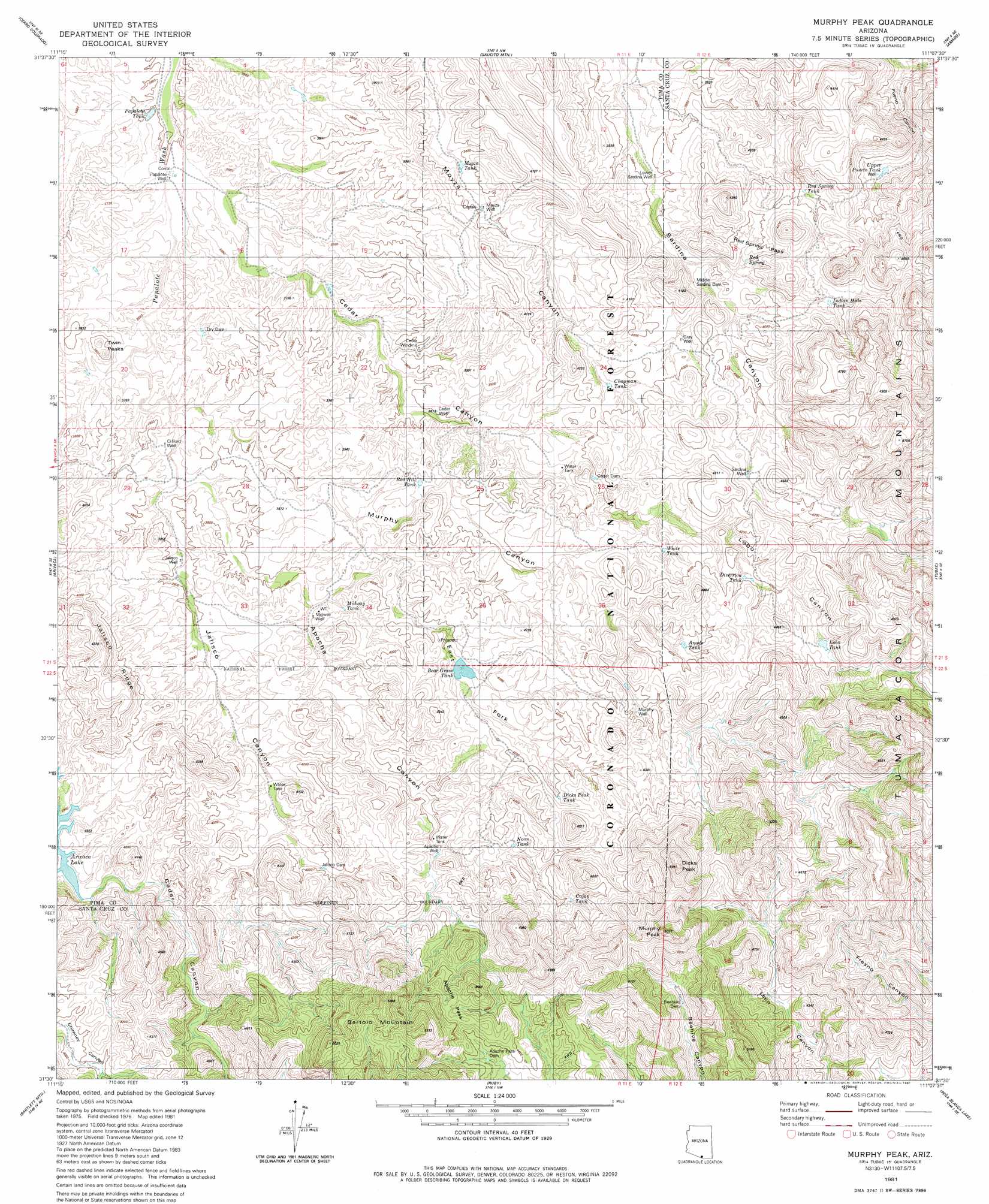
USGS Topo Quad 31111e2 - 1:24,000 scale
| Topo Map Name: | Murphy Peak |
| USGS Topo Quad ID: | 31111e2 |
| Print Size: | ca. 21 1/4" wide x 27" high |
| Southeast Coordinates: | 31.5° N latitude / 111.125° W longitude |
| Map Center Coordinates: | 31.5625° N latitude / 111.1875° W longitude |
| U.S. State: | AZ |
| Filename: | o31111e2.jpg |
| Download Map JPG Image: | Murphy Peak topo map 1:24,000 scale |
| Map Type: | Topographic |
| Topo Series: | 7.5´ |
| Map Scale: | 1:24,000 |
| Source of Map Images: | United States Geological Survey (USGS) |
| Alternate Map Versions: |
Murphy Peak AZ 1981, updated 1981 Download PDF Buy paper map Murphy Peak AZ 1981, updated 1981 Download PDF Buy paper map Murphy Peak AZ 1996, updated 2002 Download PDF Buy paper map Murphy Peak AZ 2012 Download PDF Buy paper map Murphy Peak AZ 2014 Download PDF Buy paper map |
| FStopo: | US Forest Service topo Murphy Peak is available: Download FStopo PDF Download FStopo TIF |
1:24,000 Topo Quads surrounding Murphy Peak
Fresno Wash |
Penitas Hills |
Batamote Hills |
Esperanza Mill |
Green Valley |
Las Guijas |
Cerro Colorado |
Saucito Mountain |
Amado |
Mount Hopkins |
Wilbur Canyon |
Arivaca |
Murphy Peak |
Tubac |
San Cayetano Mountains |
Cumero Mountain |
Bartlett Mountain |
Ruby |
Pena Blanca Lake |
Rio Rico |
Alamo Spring |
Pajarito Peak |
Nogales |
> Back to 31111e1 at 1:100,000 scale
> Back to 31110a1 at 1:250,000 scale
> Back to U.S. Topo Maps home
Murphy Peak topo map: Gazetteer
Murphy Peak: Dams
Apache Pass Dam elevation 1325m 4347′Beehive Dam elevation 1329m 4360′
Cedar Dam elevation 1217m 3992′
Dry Dam elevation 1134m 3720′
Jalisco Dam elevation 1212m 3976′
Middle Sardina Dam elevation 1178m 3864′
Sardina Dam elevation 1244m 4081′
Murphy Peak: Gaps
Apache Pass elevation 1399m 4589′Red Spring Pass elevation 1210m 3969′
Murphy Peak: Reservoirs
Amole Tank elevation 1271m 4169′Bear Grass Tank elevation 1232m 4041′
Cajon Tank elevation 1291m 4235′
Chapman Tank elevation 1204m 3950′
Dicks Peak Tank elevation 1283m 4209′
Diversion Tank elevation 1277m 4189′
Indian Hills Tank elevation 1241m 4071′
Lobo Tank elevation 1321m 4333′
Midway Tank elevation 1177m 3861′
Moyza Tank elevation 1150m 3772′
Noon Tank elevation 1257m 4124′
Papalote Tank elevation 1098m 3602′
Red Hill Tank elevation 1191m 3907′
Red Spring Tank elevation 1213m 3979′
Upper Puerto Tank elevation 1190m 3904′
White Tank elevation 1243m 4078′
Murphy Peak: Ridges
Jalisco Ridge elevation 1328m 4356′Murphy Peak: Springs
Red Spring elevation 1192m 3910′Turtle Spring elevation 1256m 4120′
Murphy Peak: Summits
Bartolo Mountain elevation 1626m 5334′Dicks Peak elevation 1585m 5200′
Murphy Peak elevation 1624m 5328′
Twin Peaks elevation 1168m 3832′
Murphy Peak: Valleys
Apache Canyon elevation 1145m 3756′Bartolo Canyon elevation 1164m 3818′
East Fork Apache Canyon elevation 1171m 3841′
Jalisco Canyon elevation 1145m 3756′
Lobo Canyon elevation 1272m 4173′
Murphy Canyon elevation 1135m 3723′
Murphy Peak: Wells
Apache Well elevation 1228m 4028′Cedar Well elevation 1160m 3805′
Cedar Windmill elevation 1161m 3809′
Clifford Well elevation 1138m 3733′
Jalisco Well elevation 1152m 3779′
Lower Sardina Well elevation 1148m 3766′
Midway Well elevation 1171m 3841′
Moyza Well elevation 1156m 3792′
Murphy Well elevation 1275m 4183′
Papalote Well elevation 1105m 3625′
Sardina Well elevation 1245m 4084′
Murphy Peak digital topo map on disk
Buy this Murphy Peak topo map showing relief, roads, GPS coordinates and other geographical features, as a high-resolution digital map file on DVD: