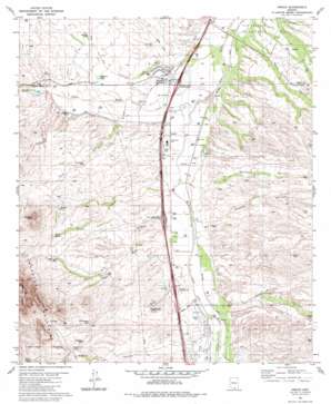
Amado Topo Map Arizona
To zoom in, hover over the map of Amado
USGS Topo Quad 31111f1 - 1:24,000 scale
| Topo Map Name: | Amado |
| USGS Topo Quad ID: | 31111f1 |
| Print Size: | ca. 21 1/4" wide x 27" high |
| Southeast Coordinates: | 31.625° N latitude / 111° W longitude |
| Map Center Coordinates: | 31.6875° N latitude / 111.0625° W longitude |
| U.S. State: | AZ |
| Filename: | o31111f1.jpg |
| Download Map JPG Image: | Amado topo map 1:24,000 scale |
| Map Type: | Topographic |
| Topo Series: | 7.5´ |
| Map Scale: | 1:24,000 |
| Source of Map Images: | United States Geological Survey (USGS) |
| Alternate Map Versions: |
Amado AZ 1981, updated 1981 Download PDF Buy paper map Amado AZ 1981, updated 1981 Download PDF Buy paper map Amado AZ 2004, updated 2006 Download PDF Buy paper map Amado AZ 2012 Download PDF Buy paper map Amado AZ 2014 Download PDF Buy paper map |
| FStopo: | US Forest Service topo Amado is available: Download FStopo PDF Download FStopo TIF |
1:24,000 Topo Quads surrounding Amado
> Back to 31111e1 at 1:100,000 scale
> Back to 31110a1 at 1:250,000 scale
> Back to U.S. Topo Maps home
Amado topo map: Gazetteer
Amado: Crossings
Agua Linda-Amado Interchange elevation 957m 3139′Arivaca-Amado Interchange elevation 938m 3077′
Chaves Interchange elevation 964m 3162′
Amado: Populated Places
Agua Linda elevation 949m 3113′Amado elevation 944m 3097′
Arivaca Junction elevation 937m 3074′
Sotos Crossing (historical) elevation 971m 3185′
Amado: Reservoirs
Diablito Tank elevation 1027m 3369′Doodlebug Tank elevation 1063m 3487′
Patterson Tank elevation 971m 3185′
Tres Puertas Tank elevation 1053m 3454′
Amado: Springs
Diablito Spring elevation 1157m 3795′Puerto Spring elevation 1104m 3622′
Toros Spring elevation 1045m 3428′
Amado: Streams
Diablo Wash elevation 939m 3080′Las Chivas Wash elevation 959m 3146′
Old Junction Wash elevation 927m 3041′
Sopori Wash elevation 923m 3028′
Toros Wash elevation 953m 3126′
Amado: Summits
Diablito Mountain elevation 1215m 3986′Diablo Mountain elevation 1508m 4947′
Amado: Valleys
Cottonwood Canyon elevation 974m 3195′Montosa Canyon elevation 959m 3146′
Puerto Canyon elevation 986m 3234′
Sheehy Canyon elevation 947m 3106′
Amado: Wells
Diablo Well elevation 1065m 3494′Lupe Well elevation 970m 3182′
New Well elevation 1002m 3287′
Rex Well elevation 960m 3149′
Tres Puertas Well elevation 1001m 3284′
Amado digital topo map on disk
Buy this Amado topo map showing relief, roads, GPS coordinates and other geographical features, as a high-resolution digital map file on DVD:


