Batamote Hills Topo Map Arizona
To zoom in, hover over the map of Batamote Hills
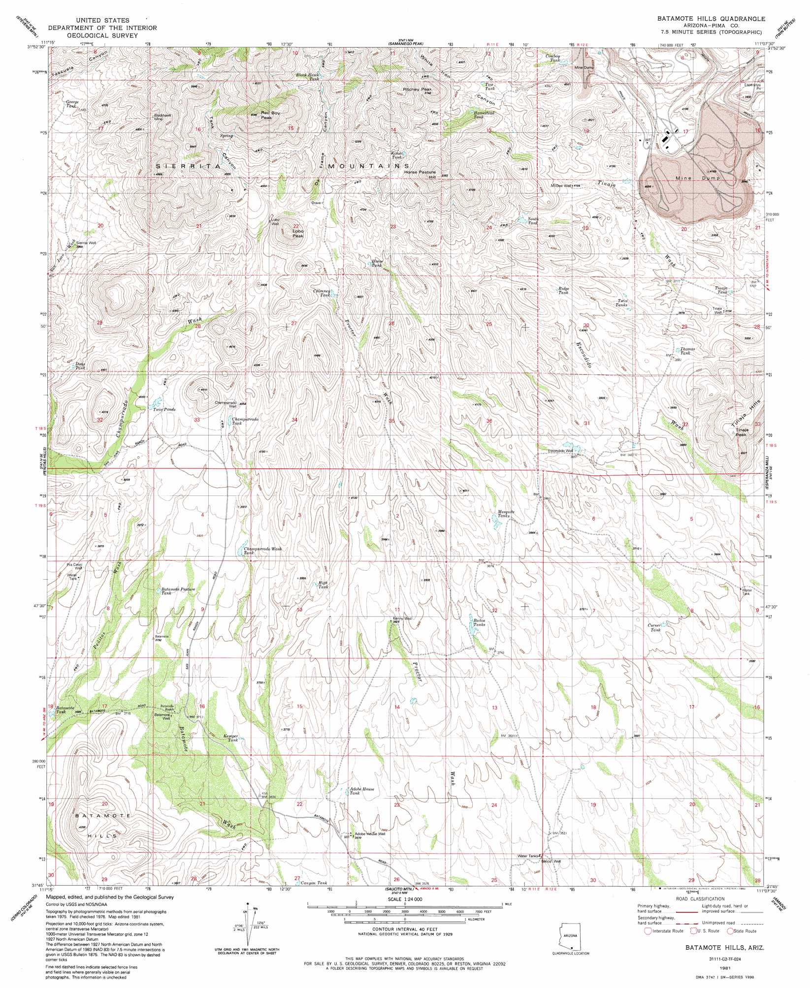
USGS Topo Quad 31111g2 - 1:24,000 scale
| Topo Map Name: | Batamote Hills |
| USGS Topo Quad ID: | 31111g2 |
| Print Size: | ca. 21 1/4" wide x 27" high |
| Southeast Coordinates: | 31.75° N latitude / 111.125° W longitude |
| Map Center Coordinates: | 31.8125° N latitude / 111.1875° W longitude |
| U.S. State: | AZ |
| Filename: | o31111g2.jpg |
| Download Map JPG Image: | Batamote Hills topo map 1:24,000 scale |
| Map Type: | Topographic |
| Topo Series: | 7.5´ |
| Map Scale: | 1:24,000 |
| Source of Map Images: | United States Geological Survey (USGS) |
| Alternate Map Versions: |
Batamote Hills AZ 1981, updated 1981 Download PDF Buy paper map Batamote Hills AZ 1981, updated 1992 Download PDF Buy paper map Batamote Hills AZ 2011 Download PDF Buy paper map Batamote Hills AZ 2014 Download PDF Buy paper map |
1:24,000 Topo Quads surrounding Batamote Hills
San Pedro |
Three Points |
San Xavier Mission Sw |
San Xavier Mission |
Tucson Sw |
Palo Alto Ranch |
Stevens Mountain |
Samaniego Peak |
Twin Buttes |
Sahuarita |
Fresno Wash |
Penitas Hills |
Batamote Hills |
Esperanza Mill |
Green Valley |
Las Guijas |
Cerro Colorado |
Saucito Mountain |
Amado |
Mount Hopkins |
Wilbur Canyon |
Arivaca |
Murphy Peak |
Tubac |
San Cayetano Mountains |
> Back to 31111e1 at 1:100,000 scale
> Back to 31110a1 at 1:250,000 scale
> Back to U.S. Topo Maps home
Batamote Hills topo map: Gazetteer
Batamote Hills: Mines
Blackhawk Mine elevation 1485m 4872′Duval Mine elevation 1170m 3838′
Esperanza Pit elevation 1108m 3635′
Sierrita Mine East Pit elevation 1119m 3671′
Batamote Hills: Reservoirs
Adobe House Tank elevation 1104m 3622′Batamote Pasture Tank elevation 1169m 3835′
Batamote Tank elevation 1109m 3638′
Black Hawk Tank elevation 1474m 4835′
Canyon Tank elevation 1077m 3533′
Champurrado Tank elevation 1227m 4025′
Champurrado Wash Tank elevation 1178m 3864′
Chimney Tank elevation 1320m 4330′
Corner Tank elevation 1104m 3622′
Cowboy Tank elevation 1291m 4235′
Dons Tank elevation 1205m 3953′
George Tank elevation 1339m 4393′
High Tank elevation 1170m 3838′
Homestead Tank elevation 1367m 4484′
Horse Tank elevation 1331m 4366′
Kemper Tank elevation 1125m 3690′
Kidoo Tank elevation 1449m 4753′
Mesquite Tanks elevation 1175m 3854′
Ridge Tank elevation 1242m 4074′
South Tank elevation 1269m 4163′
Thomas Tank elevation 1179m 3868′
Tinaja Tank elevation 1130m 3707′
Tios Tank elevation 1374m 4507′
Twin Ponds elevation 1224m 4015′
Twin Tanks elevation 1184m 3884′
Batamote Hills: Summits
Batamote Hills elevation 1294m 4245′Horse Pasture Hill elevation 1595m 5232′
Lobo Peak elevation 1499m 4917′
Red Boy Peak elevation 1808m 5931′
Ritchey Peak elevation 1559m 5114′
Tinaja Hills elevation 1359m 4458′
Tinaja Peak elevation 1356m 4448′
Batamote Hills: Valleys
Ox Frame Canyon elevation 1373m 4504′Tank Canyon elevation 1375m 4511′
Batamote Hills: Wells
Adobe House Well elevation 1089m 3572′Baños Well elevation 1063m 3487′
Batamote Well elevation 1129m 3704′
Champurrado Well elevation 1235m 4051′
Escondido Well elevation 1172m 3845′
Kenny Well elevation 1166m 3825′
Lobo Well elevation 1342m 4402′
McGee Well elevation 1252m 4107′
Pila Cerro Well elevation 1160m 3805′
Sierrita Well elevation 1219m 3999′
Tinaja Well elevation 1129m 3704′
Batamote Hills digital topo map on disk
Buy this Batamote Hills topo map showing relief, roads, GPS coordinates and other geographical features, as a high-resolution digital map file on DVD: